


25 km | 31 km-effort

User


FREE GPS app for hiking
 SityTrail
IGN / Geographical institutes
SityTrail World
The world is yours!
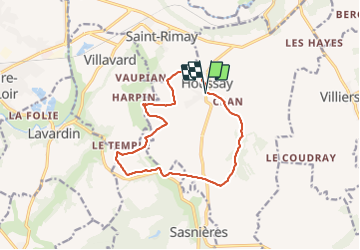
Trail Walking of 12.4 km to be discovered at Centre-Loire Valley, Loir-et-Cher, Houssay. This trail is proposed by guydu41.
Randonnée avec l'association "Les Randonneurs Montoiriens".
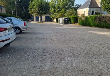
Départ depuis le parking en face de la Salle Polyvalente de Houssay 41800, Loir-et-Cher.
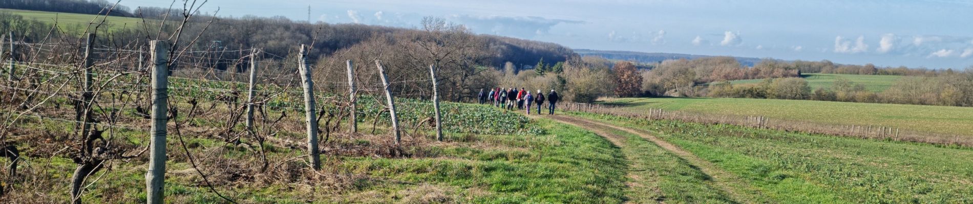
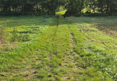
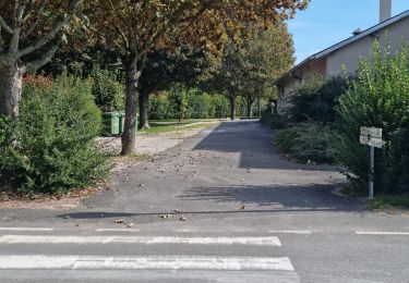
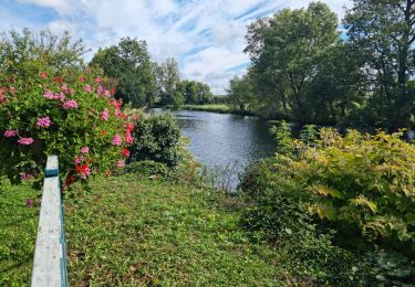
Ce circuit champêtre sillonne aux milieux de nombreux champs, passe à côté d'une très grande ferme avec un important cheptel, longe et traverse quelques bois, franchit par deux fois le cours d'eau "La Fontaine de Sasnières", chemine le long d'un ruisseau et revient au Point de départ par un passage très court mais très pentu (attention par temps de pluie).
Adresse : 7 Rue Principale, 41800 Houssay (à côté de l'école primaire)
") "
data-pinterest-text="Pin it"
data-tweet-text="share on twitter"
data-facebook-share-url="https://www.sitytrail.com/en/trails/3043355-houssay--circuit-promenades-et-randonnees-xprx-xles-manieresx/?photo=1#lg=1&slide=1"
data-twitter-share-url="https://www.sitytrail.com/en/trails/3043355-houssay--circuit-promenades-et-randonnees-xprx-xles-manieresx/?photo=1#lg=1&slide=1"
data-googleplus-share-url="https://www.sitytrail.com/en/trails/3043355-houssay--circuit-promenades-et-randonnees-xprx-xles-manieresx/?photo=1#lg=1&slide=1"
data-pinterest-share-url="https://www.sitytrail.com/en/trails/3043355-houssay--circuit-promenades-et-randonnees-xprx-xles-manieresx/?photo=1#lg=1&slide=1">
"
data-pinterest-text="Pin it"
data-tweet-text="share on twitter"
data-facebook-share-url="https://www.sitytrail.com/en/trails/3043355-houssay--circuit-promenades-et-randonnees-xprx-xles-manieresx/?photo=1#lg=1&slide=1"
data-twitter-share-url="https://www.sitytrail.com/en/trails/3043355-houssay--circuit-promenades-et-randonnees-xprx-xles-manieresx/?photo=1#lg=1&slide=1"
data-googleplus-share-url="https://www.sitytrail.com/en/trails/3043355-houssay--circuit-promenades-et-randonnees-xprx-xles-manieresx/?photo=1#lg=1&slide=1"
data-pinterest-share-url="https://www.sitytrail.com/en/trails/3043355-houssay--circuit-promenades-et-randonnees-xprx-xles-manieresx/?photo=1#lg=1&slide=1">
") "
data-pinterest-text="Pin it"
data-tweet-text="share on twitter"
data-facebook-share-url="https://www.sitytrail.com/en/trails/3043355-houssay--circuit-promenades-et-randonnees-xprx-xles-manieresx/?photo=2#lg=1&slide=2"
data-twitter-share-url="https://www.sitytrail.com/en/trails/3043355-houssay--circuit-promenades-et-randonnees-xprx-xles-manieresx/?photo=2#lg=1&slide=2"
data-googleplus-share-url="https://www.sitytrail.com/en/trails/3043355-houssay--circuit-promenades-et-randonnees-xprx-xles-manieresx/?photo=2#lg=1&slide=2"
data-pinterest-share-url="https://www.sitytrail.com/en/trails/3043355-houssay--circuit-promenades-et-randonnees-xprx-xles-manieresx/?photo=2#lg=1&slide=2">
"
data-pinterest-text="Pin it"
data-tweet-text="share on twitter"
data-facebook-share-url="https://www.sitytrail.com/en/trails/3043355-houssay--circuit-promenades-et-randonnees-xprx-xles-manieresx/?photo=2#lg=1&slide=2"
data-twitter-share-url="https://www.sitytrail.com/en/trails/3043355-houssay--circuit-promenades-et-randonnees-xprx-xles-manieresx/?photo=2#lg=1&slide=2"
data-googleplus-share-url="https://www.sitytrail.com/en/trails/3043355-houssay--circuit-promenades-et-randonnees-xprx-xles-manieresx/?photo=2#lg=1&slide=2"
data-pinterest-share-url="https://www.sitytrail.com/en/trails/3043355-houssay--circuit-promenades-et-randonnees-xprx-xles-manieresx/?photo=2#lg=1&slide=2">
") "
data-pinterest-text="Pin it"
data-tweet-text="share on twitter"
data-facebook-share-url="https://www.sitytrail.com/en/trails/3043355-houssay--circuit-promenades-et-randonnees-xprx-xles-manieresx/?photo=3#lg=1&slide=3"
data-twitter-share-url="https://www.sitytrail.com/en/trails/3043355-houssay--circuit-promenades-et-randonnees-xprx-xles-manieresx/?photo=3#lg=1&slide=3"
data-googleplus-share-url="https://www.sitytrail.com/en/trails/3043355-houssay--circuit-promenades-et-randonnees-xprx-xles-manieresx/?photo=3#lg=1&slide=3"
data-pinterest-share-url="https://www.sitytrail.com/en/trails/3043355-houssay--circuit-promenades-et-randonnees-xprx-xles-manieresx/?photo=3#lg=1&slide=3">
"
data-pinterest-text="Pin it"
data-tweet-text="share on twitter"
data-facebook-share-url="https://www.sitytrail.com/en/trails/3043355-houssay--circuit-promenades-et-randonnees-xprx-xles-manieresx/?photo=3#lg=1&slide=3"
data-twitter-share-url="https://www.sitytrail.com/en/trails/3043355-houssay--circuit-promenades-et-randonnees-xprx-xles-manieresx/?photo=3#lg=1&slide=3"
data-googleplus-share-url="https://www.sitytrail.com/en/trails/3043355-houssay--circuit-promenades-et-randonnees-xprx-xles-manieresx/?photo=3#lg=1&slide=3"
data-pinterest-share-url="https://www.sitytrail.com/en/trails/3043355-houssay--circuit-promenades-et-randonnees-xprx-xles-manieresx/?photo=3#lg=1&slide=3">
") "
data-pinterest-text="Pin it"
data-tweet-text="share on twitter"
data-facebook-share-url="https://www.sitytrail.com/en/trails/3043355-houssay--circuit-promenades-et-randonnees-xprx-xles-manieresx/?photo=4#lg=1&slide=4"
data-twitter-share-url="https://www.sitytrail.com/en/trails/3043355-houssay--circuit-promenades-et-randonnees-xprx-xles-manieresx/?photo=4#lg=1&slide=4"
data-googleplus-share-url="https://www.sitytrail.com/en/trails/3043355-houssay--circuit-promenades-et-randonnees-xprx-xles-manieresx/?photo=4#lg=1&slide=4"
data-pinterest-share-url="https://www.sitytrail.com/en/trails/3043355-houssay--circuit-promenades-et-randonnees-xprx-xles-manieresx/?photo=4#lg=1&slide=4">
"
data-pinterest-text="Pin it"
data-tweet-text="share on twitter"
data-facebook-share-url="https://www.sitytrail.com/en/trails/3043355-houssay--circuit-promenades-et-randonnees-xprx-xles-manieresx/?photo=4#lg=1&slide=4"
data-twitter-share-url="https://www.sitytrail.com/en/trails/3043355-houssay--circuit-promenades-et-randonnees-xprx-xles-manieresx/?photo=4#lg=1&slide=4"
data-googleplus-share-url="https://www.sitytrail.com/en/trails/3043355-houssay--circuit-promenades-et-randonnees-xprx-xles-manieresx/?photo=4#lg=1&slide=4"
data-pinterest-share-url="https://www.sitytrail.com/en/trails/3043355-houssay--circuit-promenades-et-randonnees-xprx-xles-manieresx/?photo=4#lg=1&slide=4">
") "
data-pinterest-text="Pin it"
data-tweet-text="share on twitter"
data-facebook-share-url="https://www.sitytrail.com/en/trails/3043355-houssay--circuit-promenades-et-randonnees-xprx-xles-manieresx/?photo=5#lg=1&slide=5"
data-twitter-share-url="https://www.sitytrail.com/en/trails/3043355-houssay--circuit-promenades-et-randonnees-xprx-xles-manieresx/?photo=5#lg=1&slide=5"
data-googleplus-share-url="https://www.sitytrail.com/en/trails/3043355-houssay--circuit-promenades-et-randonnees-xprx-xles-manieresx/?photo=5#lg=1&slide=5"
data-pinterest-share-url="https://www.sitytrail.com/en/trails/3043355-houssay--circuit-promenades-et-randonnees-xprx-xles-manieresx/?photo=5#lg=1&slide=5">
"
data-pinterest-text="Pin it"
data-tweet-text="share on twitter"
data-facebook-share-url="https://www.sitytrail.com/en/trails/3043355-houssay--circuit-promenades-et-randonnees-xprx-xles-manieresx/?photo=5#lg=1&slide=5"
data-twitter-share-url="https://www.sitytrail.com/en/trails/3043355-houssay--circuit-promenades-et-randonnees-xprx-xles-manieresx/?photo=5#lg=1&slide=5"
data-googleplus-share-url="https://www.sitytrail.com/en/trails/3043355-houssay--circuit-promenades-et-randonnees-xprx-xles-manieresx/?photo=5#lg=1&slide=5"
data-pinterest-share-url="https://www.sitytrail.com/en/trails/3043355-houssay--circuit-promenades-et-randonnees-xprx-xles-manieresx/?photo=5#lg=1&slide=5">
") "
data-pinterest-text="Pin it"
data-tweet-text="share on twitter"
data-facebook-share-url="https://www.sitytrail.com/en/trails/3043355-houssay--circuit-promenades-et-randonnees-xprx-xles-manieresx/?photo=6#lg=1&slide=6"
data-twitter-share-url="https://www.sitytrail.com/en/trails/3043355-houssay--circuit-promenades-et-randonnees-xprx-xles-manieresx/?photo=6#lg=1&slide=6"
data-googleplus-share-url="https://www.sitytrail.com/en/trails/3043355-houssay--circuit-promenades-et-randonnees-xprx-xles-manieresx/?photo=6#lg=1&slide=6"
data-pinterest-share-url="https://www.sitytrail.com/en/trails/3043355-houssay--circuit-promenades-et-randonnees-xprx-xles-manieresx/?photo=6#lg=1&slide=6">
"
data-pinterest-text="Pin it"
data-tweet-text="share on twitter"
data-facebook-share-url="https://www.sitytrail.com/en/trails/3043355-houssay--circuit-promenades-et-randonnees-xprx-xles-manieresx/?photo=6#lg=1&slide=6"
data-twitter-share-url="https://www.sitytrail.com/en/trails/3043355-houssay--circuit-promenades-et-randonnees-xprx-xles-manieresx/?photo=6#lg=1&slide=6"
data-googleplus-share-url="https://www.sitytrail.com/en/trails/3043355-houssay--circuit-promenades-et-randonnees-xprx-xles-manieresx/?photo=6#lg=1&slide=6"
data-pinterest-share-url="https://www.sitytrail.com/en/trails/3043355-houssay--circuit-promenades-et-randonnees-xprx-xles-manieresx/?photo=6#lg=1&slide=6">
") "
data-pinterest-text="Pin it"
data-tweet-text="share on twitter"
data-facebook-share-url="https://www.sitytrail.com/en/trails/3043355-houssay--circuit-promenades-et-randonnees-xprx-xles-manieresx/?photo=7#lg=1&slide=7"
data-twitter-share-url="https://www.sitytrail.com/en/trails/3043355-houssay--circuit-promenades-et-randonnees-xprx-xles-manieresx/?photo=7#lg=1&slide=7"
data-googleplus-share-url="https://www.sitytrail.com/en/trails/3043355-houssay--circuit-promenades-et-randonnees-xprx-xles-manieresx/?photo=7#lg=1&slide=7"
data-pinterest-share-url="https://www.sitytrail.com/en/trails/3043355-houssay--circuit-promenades-et-randonnees-xprx-xles-manieresx/?photo=7#lg=1&slide=7">
"
data-pinterest-text="Pin it"
data-tweet-text="share on twitter"
data-facebook-share-url="https://www.sitytrail.com/en/trails/3043355-houssay--circuit-promenades-et-randonnees-xprx-xles-manieresx/?photo=7#lg=1&slide=7"
data-twitter-share-url="https://www.sitytrail.com/en/trails/3043355-houssay--circuit-promenades-et-randonnees-xprx-xles-manieresx/?photo=7#lg=1&slide=7"
data-googleplus-share-url="https://www.sitytrail.com/en/trails/3043355-houssay--circuit-promenades-et-randonnees-xprx-xles-manieresx/?photo=7#lg=1&slide=7"
data-pinterest-share-url="https://www.sitytrail.com/en/trails/3043355-houssay--circuit-promenades-et-randonnees-xprx-xles-manieresx/?photo=7#lg=1&slide=7">
") "
data-pinterest-text="Pin it"
data-tweet-text="share on twitter"
data-facebook-share-url="https://www.sitytrail.com/en/trails/3043355-houssay--circuit-promenades-et-randonnees-xprx-xles-manieresx/?photo=8#lg=1&slide=8"
data-twitter-share-url="https://www.sitytrail.com/en/trails/3043355-houssay--circuit-promenades-et-randonnees-xprx-xles-manieresx/?photo=8#lg=1&slide=8"
data-googleplus-share-url="https://www.sitytrail.com/en/trails/3043355-houssay--circuit-promenades-et-randonnees-xprx-xles-manieresx/?photo=8#lg=1&slide=8"
data-pinterest-share-url="https://www.sitytrail.com/en/trails/3043355-houssay--circuit-promenades-et-randonnees-xprx-xles-manieresx/?photo=8#lg=1&slide=8">
"
data-pinterest-text="Pin it"
data-tweet-text="share on twitter"
data-facebook-share-url="https://www.sitytrail.com/en/trails/3043355-houssay--circuit-promenades-et-randonnees-xprx-xles-manieresx/?photo=8#lg=1&slide=8"
data-twitter-share-url="https://www.sitytrail.com/en/trails/3043355-houssay--circuit-promenades-et-randonnees-xprx-xles-manieresx/?photo=8#lg=1&slide=8"
data-googleplus-share-url="https://www.sitytrail.com/en/trails/3043355-houssay--circuit-promenades-et-randonnees-xprx-xles-manieresx/?photo=8#lg=1&slide=8"
data-pinterest-share-url="https://www.sitytrail.com/en/trails/3043355-houssay--circuit-promenades-et-randonnees-xprx-xles-manieresx/?photo=8#lg=1&slide=8">
") "
data-pinterest-text="Pin it"
data-tweet-text="share on twitter"
data-facebook-share-url="https://www.sitytrail.com/en/trails/3043355-houssay--circuit-promenades-et-randonnees-xprx-xles-manieresx/?photo=9#lg=1&slide=9"
data-twitter-share-url="https://www.sitytrail.com/en/trails/3043355-houssay--circuit-promenades-et-randonnees-xprx-xles-manieresx/?photo=9#lg=1&slide=9"
data-googleplus-share-url="https://www.sitytrail.com/en/trails/3043355-houssay--circuit-promenades-et-randonnees-xprx-xles-manieresx/?photo=9#lg=1&slide=9"
data-pinterest-share-url="https://www.sitytrail.com/en/trails/3043355-houssay--circuit-promenades-et-randonnees-xprx-xles-manieresx/?photo=9#lg=1&slide=9">
"
data-pinterest-text="Pin it"
data-tweet-text="share on twitter"
data-facebook-share-url="https://www.sitytrail.com/en/trails/3043355-houssay--circuit-promenades-et-randonnees-xprx-xles-manieresx/?photo=9#lg=1&slide=9"
data-twitter-share-url="https://www.sitytrail.com/en/trails/3043355-houssay--circuit-promenades-et-randonnees-xprx-xles-manieresx/?photo=9#lg=1&slide=9"
data-googleplus-share-url="https://www.sitytrail.com/en/trails/3043355-houssay--circuit-promenades-et-randonnees-xprx-xles-manieresx/?photo=9#lg=1&slide=9"
data-pinterest-share-url="https://www.sitytrail.com/en/trails/3043355-houssay--circuit-promenades-et-randonnees-xprx-xles-manieresx/?photo=9#lg=1&slide=9">
") "
data-pinterest-text="Pin it"
data-tweet-text="share on twitter"
data-facebook-share-url="https://www.sitytrail.com/en/trails/3043355-houssay--circuit-promenades-et-randonnees-xprx-xles-manieresx/?photo=10#lg=1&slide=10"
data-twitter-share-url="https://www.sitytrail.com/en/trails/3043355-houssay--circuit-promenades-et-randonnees-xprx-xles-manieresx/?photo=10#lg=1&slide=10"
data-googleplus-share-url="https://www.sitytrail.com/en/trails/3043355-houssay--circuit-promenades-et-randonnees-xprx-xles-manieresx/?photo=10#lg=1&slide=10"
data-pinterest-share-url="https://www.sitytrail.com/en/trails/3043355-houssay--circuit-promenades-et-randonnees-xprx-xles-manieresx/?photo=10#lg=1&slide=10">
"
data-pinterest-text="Pin it"
data-tweet-text="share on twitter"
data-facebook-share-url="https://www.sitytrail.com/en/trails/3043355-houssay--circuit-promenades-et-randonnees-xprx-xles-manieresx/?photo=10#lg=1&slide=10"
data-twitter-share-url="https://www.sitytrail.com/en/trails/3043355-houssay--circuit-promenades-et-randonnees-xprx-xles-manieresx/?photo=10#lg=1&slide=10"
data-googleplus-share-url="https://www.sitytrail.com/en/trails/3043355-houssay--circuit-promenades-et-randonnees-xprx-xles-manieresx/?photo=10#lg=1&slide=10"
data-pinterest-share-url="https://www.sitytrail.com/en/trails/3043355-houssay--circuit-promenades-et-randonnees-xprx-xles-manieresx/?photo=10#lg=1&slide=10">
") "
data-pinterest-text="Pin it"
data-tweet-text="share on twitter"
data-facebook-share-url="https://www.sitytrail.com/en/trails/3043355-houssay--circuit-promenades-et-randonnees-xprx-xles-manieresx/?photo=11#lg=1&slide=11"
data-twitter-share-url="https://www.sitytrail.com/en/trails/3043355-houssay--circuit-promenades-et-randonnees-xprx-xles-manieresx/?photo=11#lg=1&slide=11"
data-googleplus-share-url="https://www.sitytrail.com/en/trails/3043355-houssay--circuit-promenades-et-randonnees-xprx-xles-manieresx/?photo=11#lg=1&slide=11"
data-pinterest-share-url="https://www.sitytrail.com/en/trails/3043355-houssay--circuit-promenades-et-randonnees-xprx-xles-manieresx/?photo=11#lg=1&slide=11">
"
data-pinterest-text="Pin it"
data-tweet-text="share on twitter"
data-facebook-share-url="https://www.sitytrail.com/en/trails/3043355-houssay--circuit-promenades-et-randonnees-xprx-xles-manieresx/?photo=11#lg=1&slide=11"
data-twitter-share-url="https://www.sitytrail.com/en/trails/3043355-houssay--circuit-promenades-et-randonnees-xprx-xles-manieresx/?photo=11#lg=1&slide=11"
data-googleplus-share-url="https://www.sitytrail.com/en/trails/3043355-houssay--circuit-promenades-et-randonnees-xprx-xles-manieresx/?photo=11#lg=1&slide=11"
data-pinterest-share-url="https://www.sitytrail.com/en/trails/3043355-houssay--circuit-promenades-et-randonnees-xprx-xles-manieresx/?photo=11#lg=1&slide=11">
") "
data-pinterest-text="Pin it"
data-tweet-text="share on twitter"
data-facebook-share-url="https://www.sitytrail.com/en/trails/3043355-houssay--circuit-promenades-et-randonnees-xprx-xles-manieresx/?photo=12#lg=1&slide=12"
data-twitter-share-url="https://www.sitytrail.com/en/trails/3043355-houssay--circuit-promenades-et-randonnees-xprx-xles-manieresx/?photo=12#lg=1&slide=12"
data-googleplus-share-url="https://www.sitytrail.com/en/trails/3043355-houssay--circuit-promenades-et-randonnees-xprx-xles-manieresx/?photo=12#lg=1&slide=12"
data-pinterest-share-url="https://www.sitytrail.com/en/trails/3043355-houssay--circuit-promenades-et-randonnees-xprx-xles-manieresx/?photo=12#lg=1&slide=12">
"
data-pinterest-text="Pin it"
data-tweet-text="share on twitter"
data-facebook-share-url="https://www.sitytrail.com/en/trails/3043355-houssay--circuit-promenades-et-randonnees-xprx-xles-manieresx/?photo=12#lg=1&slide=12"
data-twitter-share-url="https://www.sitytrail.com/en/trails/3043355-houssay--circuit-promenades-et-randonnees-xprx-xles-manieresx/?photo=12#lg=1&slide=12"
data-googleplus-share-url="https://www.sitytrail.com/en/trails/3043355-houssay--circuit-promenades-et-randonnees-xprx-xles-manieresx/?photo=12#lg=1&slide=12"
data-pinterest-share-url="https://www.sitytrail.com/en/trails/3043355-houssay--circuit-promenades-et-randonnees-xprx-xles-manieresx/?photo=12#lg=1&slide=12">
") "
data-pinterest-text="Pin it"
data-tweet-text="share on twitter"
data-facebook-share-url="https://www.sitytrail.com/en/trails/3043355-houssay--circuit-promenades-et-randonnees-xprx-xles-manieresx/?photo=13#lg=1&slide=13"
data-twitter-share-url="https://www.sitytrail.com/en/trails/3043355-houssay--circuit-promenades-et-randonnees-xprx-xles-manieresx/?photo=13#lg=1&slide=13"
data-googleplus-share-url="https://www.sitytrail.com/en/trails/3043355-houssay--circuit-promenades-et-randonnees-xprx-xles-manieresx/?photo=13#lg=1&slide=13"
data-pinterest-share-url="https://www.sitytrail.com/en/trails/3043355-houssay--circuit-promenades-et-randonnees-xprx-xles-manieresx/?photo=13#lg=1&slide=13">
"
data-pinterest-text="Pin it"
data-tweet-text="share on twitter"
data-facebook-share-url="https://www.sitytrail.com/en/trails/3043355-houssay--circuit-promenades-et-randonnees-xprx-xles-manieresx/?photo=13#lg=1&slide=13"
data-twitter-share-url="https://www.sitytrail.com/en/trails/3043355-houssay--circuit-promenades-et-randonnees-xprx-xles-manieresx/?photo=13#lg=1&slide=13"
data-googleplus-share-url="https://www.sitytrail.com/en/trails/3043355-houssay--circuit-promenades-et-randonnees-xprx-xles-manieresx/?photo=13#lg=1&slide=13"
data-pinterest-share-url="https://www.sitytrail.com/en/trails/3043355-houssay--circuit-promenades-et-randonnees-xprx-xles-manieresx/?photo=13#lg=1&slide=13">
") "
data-pinterest-text="Pin it"
data-tweet-text="share on twitter"
data-facebook-share-url="https://www.sitytrail.com/en/trails/3043355-houssay--circuit-promenades-et-randonnees-xprx-xles-manieresx/?photo=14#lg=1&slide=14"
data-twitter-share-url="https://www.sitytrail.com/en/trails/3043355-houssay--circuit-promenades-et-randonnees-xprx-xles-manieresx/?photo=14#lg=1&slide=14"
data-googleplus-share-url="https://www.sitytrail.com/en/trails/3043355-houssay--circuit-promenades-et-randonnees-xprx-xles-manieresx/?photo=14#lg=1&slide=14"
data-pinterest-share-url="https://www.sitytrail.com/en/trails/3043355-houssay--circuit-promenades-et-randonnees-xprx-xles-manieresx/?photo=14#lg=1&slide=14">
"
data-pinterest-text="Pin it"
data-tweet-text="share on twitter"
data-facebook-share-url="https://www.sitytrail.com/en/trails/3043355-houssay--circuit-promenades-et-randonnees-xprx-xles-manieresx/?photo=14#lg=1&slide=14"
data-twitter-share-url="https://www.sitytrail.com/en/trails/3043355-houssay--circuit-promenades-et-randonnees-xprx-xles-manieresx/?photo=14#lg=1&slide=14"
data-googleplus-share-url="https://www.sitytrail.com/en/trails/3043355-houssay--circuit-promenades-et-randonnees-xprx-xles-manieresx/?photo=14#lg=1&slide=14"
data-pinterest-share-url="https://www.sitytrail.com/en/trails/3043355-houssay--circuit-promenades-et-randonnees-xprx-xles-manieresx/?photo=14#lg=1&slide=14">
") "
data-pinterest-text="Pin it"
data-tweet-text="share on twitter"
data-facebook-share-url="https://www.sitytrail.com/en/trails/3043355-houssay--circuit-promenades-et-randonnees-xprx-xles-manieresx/?photo=15#lg=1&slide=15"
data-twitter-share-url="https://www.sitytrail.com/en/trails/3043355-houssay--circuit-promenades-et-randonnees-xprx-xles-manieresx/?photo=15#lg=1&slide=15"
data-googleplus-share-url="https://www.sitytrail.com/en/trails/3043355-houssay--circuit-promenades-et-randonnees-xprx-xles-manieresx/?photo=15#lg=1&slide=15"
data-pinterest-share-url="https://www.sitytrail.com/en/trails/3043355-houssay--circuit-promenades-et-randonnees-xprx-xles-manieresx/?photo=15#lg=1&slide=15">
"
data-pinterest-text="Pin it"
data-tweet-text="share on twitter"
data-facebook-share-url="https://www.sitytrail.com/en/trails/3043355-houssay--circuit-promenades-et-randonnees-xprx-xles-manieresx/?photo=15#lg=1&slide=15"
data-twitter-share-url="https://www.sitytrail.com/en/trails/3043355-houssay--circuit-promenades-et-randonnees-xprx-xles-manieresx/?photo=15#lg=1&slide=15"
data-googleplus-share-url="https://www.sitytrail.com/en/trails/3043355-houssay--circuit-promenades-et-randonnees-xprx-xles-manieresx/?photo=15#lg=1&slide=15"
data-pinterest-share-url="https://www.sitytrail.com/en/trails/3043355-houssay--circuit-promenades-et-randonnees-xprx-xles-manieresx/?photo=15#lg=1&slide=15">
") "
data-pinterest-text="Pin it"
data-tweet-text="share on twitter"
data-facebook-share-url="https://www.sitytrail.com/en/trails/3043355-houssay--circuit-promenades-et-randonnees-xprx-xles-manieresx/?photo=16#lg=1&slide=16"
data-twitter-share-url="https://www.sitytrail.com/en/trails/3043355-houssay--circuit-promenades-et-randonnees-xprx-xles-manieresx/?photo=16#lg=1&slide=16"
data-googleplus-share-url="https://www.sitytrail.com/en/trails/3043355-houssay--circuit-promenades-et-randonnees-xprx-xles-manieresx/?photo=16#lg=1&slide=16"
data-pinterest-share-url="https://www.sitytrail.com/en/trails/3043355-houssay--circuit-promenades-et-randonnees-xprx-xles-manieresx/?photo=16#lg=1&slide=16">
"
data-pinterest-text="Pin it"
data-tweet-text="share on twitter"
data-facebook-share-url="https://www.sitytrail.com/en/trails/3043355-houssay--circuit-promenades-et-randonnees-xprx-xles-manieresx/?photo=16#lg=1&slide=16"
data-twitter-share-url="https://www.sitytrail.com/en/trails/3043355-houssay--circuit-promenades-et-randonnees-xprx-xles-manieresx/?photo=16#lg=1&slide=16"
data-googleplus-share-url="https://www.sitytrail.com/en/trails/3043355-houssay--circuit-promenades-et-randonnees-xprx-xles-manieresx/?photo=16#lg=1&slide=16"
data-pinterest-share-url="https://www.sitytrail.com/en/trails/3043355-houssay--circuit-promenades-et-randonnees-xprx-xles-manieresx/?photo=16#lg=1&slide=16">
") "
data-pinterest-text="Pin it"
data-tweet-text="share on twitter"
data-facebook-share-url="https://www.sitytrail.com/en/trails/3043355-houssay--circuit-promenades-et-randonnees-xprx-xles-manieresx/?photo=17#lg=1&slide=17"
data-twitter-share-url="https://www.sitytrail.com/en/trails/3043355-houssay--circuit-promenades-et-randonnees-xprx-xles-manieresx/?photo=17#lg=1&slide=17"
data-googleplus-share-url="https://www.sitytrail.com/en/trails/3043355-houssay--circuit-promenades-et-randonnees-xprx-xles-manieresx/?photo=17#lg=1&slide=17"
data-pinterest-share-url="https://www.sitytrail.com/en/trails/3043355-houssay--circuit-promenades-et-randonnees-xprx-xles-manieresx/?photo=17#lg=1&slide=17">
"
data-pinterest-text="Pin it"
data-tweet-text="share on twitter"
data-facebook-share-url="https://www.sitytrail.com/en/trails/3043355-houssay--circuit-promenades-et-randonnees-xprx-xles-manieresx/?photo=17#lg=1&slide=17"
data-twitter-share-url="https://www.sitytrail.com/en/trails/3043355-houssay--circuit-promenades-et-randonnees-xprx-xles-manieresx/?photo=17#lg=1&slide=17"
data-googleplus-share-url="https://www.sitytrail.com/en/trails/3043355-houssay--circuit-promenades-et-randonnees-xprx-xles-manieresx/?photo=17#lg=1&slide=17"
data-pinterest-share-url="https://www.sitytrail.com/en/trails/3043355-houssay--circuit-promenades-et-randonnees-xprx-xles-manieresx/?photo=17#lg=1&slide=17">
") "
data-pinterest-text="Pin it"
data-tweet-text="share on twitter"
data-facebook-share-url="https://www.sitytrail.com/en/trails/3043355-houssay--circuit-promenades-et-randonnees-xprx-xles-manieresx/?photo=18#lg=1&slide=18"
data-twitter-share-url="https://www.sitytrail.com/en/trails/3043355-houssay--circuit-promenades-et-randonnees-xprx-xles-manieresx/?photo=18#lg=1&slide=18"
data-googleplus-share-url="https://www.sitytrail.com/en/trails/3043355-houssay--circuit-promenades-et-randonnees-xprx-xles-manieresx/?photo=18#lg=1&slide=18"
data-pinterest-share-url="https://www.sitytrail.com/en/trails/3043355-houssay--circuit-promenades-et-randonnees-xprx-xles-manieresx/?photo=18#lg=1&slide=18">
"
data-pinterest-text="Pin it"
data-tweet-text="share on twitter"
data-facebook-share-url="https://www.sitytrail.com/en/trails/3043355-houssay--circuit-promenades-et-randonnees-xprx-xles-manieresx/?photo=18#lg=1&slide=18"
data-twitter-share-url="https://www.sitytrail.com/en/trails/3043355-houssay--circuit-promenades-et-randonnees-xprx-xles-manieresx/?photo=18#lg=1&slide=18"
data-googleplus-share-url="https://www.sitytrail.com/en/trails/3043355-houssay--circuit-promenades-et-randonnees-xprx-xles-manieresx/?photo=18#lg=1&slide=18"
data-pinterest-share-url="https://www.sitytrail.com/en/trails/3043355-houssay--circuit-promenades-et-randonnees-xprx-xles-manieresx/?photo=18#lg=1&slide=18">
") "
data-pinterest-text="Pin it"
data-tweet-text="share on twitter"
data-facebook-share-url="https://www.sitytrail.com/en/trails/3043355-houssay--circuit-promenades-et-randonnees-xprx-xles-manieresx/?photo=19#lg=1&slide=19"
data-twitter-share-url="https://www.sitytrail.com/en/trails/3043355-houssay--circuit-promenades-et-randonnees-xprx-xles-manieresx/?photo=19#lg=1&slide=19"
data-googleplus-share-url="https://www.sitytrail.com/en/trails/3043355-houssay--circuit-promenades-et-randonnees-xprx-xles-manieresx/?photo=19#lg=1&slide=19"
data-pinterest-share-url="https://www.sitytrail.com/en/trails/3043355-houssay--circuit-promenades-et-randonnees-xprx-xles-manieresx/?photo=19#lg=1&slide=19">
"
data-pinterest-text="Pin it"
data-tweet-text="share on twitter"
data-facebook-share-url="https://www.sitytrail.com/en/trails/3043355-houssay--circuit-promenades-et-randonnees-xprx-xles-manieresx/?photo=19#lg=1&slide=19"
data-twitter-share-url="https://www.sitytrail.com/en/trails/3043355-houssay--circuit-promenades-et-randonnees-xprx-xles-manieresx/?photo=19#lg=1&slide=19"
data-googleplus-share-url="https://www.sitytrail.com/en/trails/3043355-houssay--circuit-promenades-et-randonnees-xprx-xles-manieresx/?photo=19#lg=1&slide=19"
data-pinterest-share-url="https://www.sitytrail.com/en/trails/3043355-houssay--circuit-promenades-et-randonnees-xprx-xles-manieresx/?photo=19#lg=1&slide=19">
")
Walking
Walking
Walking
Walking
Walking
Walking
Walking
Walking
Walking