![](/images/other/stat-length.png)
![Trail Walking Laborel - Montagne de Chamouse - Photo](https://media.geolcdn.com/t/1900/400/6ca43a5e-7183-48f1-b61e-fd0f610bad24.jpg&format=pjpeg&maxdim=2)
Montagne de Chamouse
PapouBertrand
User
![Length](/images/other/stat-length.png)
Length
11.4 km
![Max alt](https://static1.geolcdn.com/siteimages/upload/files/1508320355ic_sort_altitude_max_24dp.png)
Max alt
1524 m
![Uphill gradient](https://static1.geolcdn.com/siteimages/upload/files/1508320355ic_sort_den_pos_24dp.png)
Uphill gradient
536 m
![Km-Effort](/images/other/stat-length.png)
Km-Effort
18.6 km
![Min alt](https://static1.geolcdn.com/siteimages/upload/files/1508320355ic_sort_altitude_min_24dp.png)
Min alt
1043 m
![Downhill gradient](https://static1.geolcdn.com/siteimages/upload/files/1508320355ic_sort_den_neg_24dp.png)
Downhill gradient
535 m
![Boucle](https://static1.geolcdn.com/siteimages/upload/files/16400158638029165_repeat_loop_refresh_sync_direction_icon.png)
Boucle
Yes
Creation date :
2022-01-06 08:27:36.973
Updated on :
2022-01-06 16:41:50.147
![Walking](https://static1.geolcdn.com/sitytour/trail-icons/101.png)
3h23
Difficulty : Difficult
![Scan this QR Code to open this trail in the SityTrail application](https://capi.geolives.com/qq0zvz2zws4bq2lad0pu/sitytour/trails/3042987/qr.png?size=200)
FREE GPS app for hiking
About
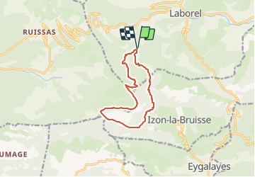
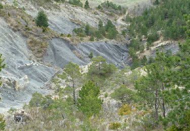
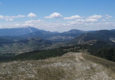
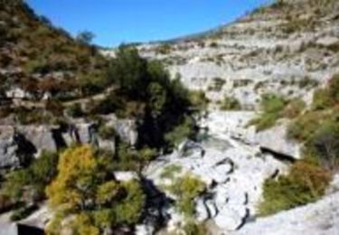
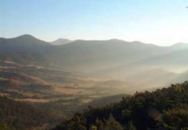
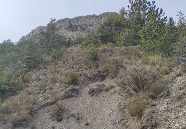
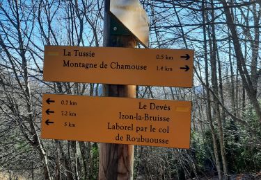
Trail Walking of 11.4 km to be discovered at Auvergne-Rhône-Alpes, Drôme, Laborel. This trail is proposed by PapouBertrand.
Description
Aucune difficulté, la piste d'accès en voiture via Jouve peut être un peu difficile jusqu'à la cote 1043. Il est possible de commencer la rando à la cote 1117 en passant par la piste au dessus de la ferme la Montagne.
Positioning
Country:
France
Region :
Auvergne-Rhône-Alpes
Department/Province :
Drôme
Municipality :
Laborel
Location:
Unknown
Start:(Dec)
Start:(UTM)
705291 ; 4906212 (31T) N.
Comments
Trails nearby
![Trail Walking Montauban-sur-l'Ouvèze - Montagne de Chamouse - Photo](https://media.geolcdn.com/t/375/260/9a974ec8-193f-4272-bf70-c8080a54eb0e.jpg&format=jpg&maxdim=2)
![Walking Walking](https://static1.geolcdn.com/sitytour/trail-icons/101.png)
Montagne de Chamouse
Walking
Difficult
Montauban-sur-l'Ouvèze,
Auvergne-Rhône-Alpes,
Drôme,
France
![](/images/other/stat-length.png)
22 km | 38 km-effort
6h 28min
![](https://static1.geolcdn.com/siteimages/upload/files/16400158638029165_repeat_loop_refresh_sync_direction_icon.png)
Yes
![Trail Walking Montauban-sur-l'Ouvèze - LABOREL 26 , COL DE PERTY. MONTAGNE DE CHAMOUSE O m s - Photo](https://media.geolcdn.com/t/375/260/71ed4cbe-2cb1-4563-8183-7a9f39949568.jpg&format=jpg&maxdim=2)
![Walking Walking](https://static1.geolcdn.com/sitytour/trail-icons/101.png)
LABOREL 26 , COL DE PERTY. MONTAGNE DE CHAMOUSE O m s
Walking
Medium
Montauban-sur-l'Ouvèze,
Auvergne-Rhône-Alpes,
Drôme,
France
![](/images/other/stat-length.png)
9.8 km | 15.6 km-effort
3h 19min
![](https://static1.geolcdn.com/siteimages/upload/files/16400158638029165_repeat_loop_refresh_sync_direction_icon.png)
Yes
![Trail Walking Laborel - Crête de Chamouse - Laborel - Photo](https://media.geolcdn.com/t/375/260/ext.jpg?maxdim=2&url=https%3A%2F%2Fservices.sitytrail.com%2FGeolivesWS%2FDownloadMedia.ashx%3FTrailID%3D173182%26Media%3D14764_6.jpg)
![Walking Walking](https://static1.geolcdn.com/sitytour/trail-icons/101.png)
Crête de Chamouse - Laborel
Walking
Medium
Laborel,
Auvergne-Rhône-Alpes,
Drôme,
France
![](/images/other/stat-length.png)
11.4 km | 19.2 km-effort
3h 30min
![](https://static1.geolcdn.com/siteimages/upload/files/16400158638029165_repeat_loop_refresh_sync_direction_icon.png)
Yes
![Trail Walking Montauban-sur-l'Ouvèze - chamouse par sonecure - Photo](https://media.geolcdn.com/t/375/260/b6865c0d-efc0-418a-8912-23683b8cd0fc.jpg&format=jpg&maxdim=2)
![Walking Walking](https://static1.geolcdn.com/sitytour/trail-icons/101.png)
chamouse par sonecure
Walking
Medium
Montauban-sur-l'Ouvèze,
Auvergne-Rhône-Alpes,
Drôme,
France
![](/images/other/stat-length.png)
14.6 km | 25 km-effort
4h 59min
![](https://static1.geolcdn.com/siteimages/upload/files/16400158638029165_repeat_loop_refresh_sync_direction_icon.png)
Yes
![Trail Walking Laborel - Tour des Baronnies du Buëch - Laborel - Orpierre - Photo](https://media.geolcdn.com/t/375/260/ext.jpg?maxdim=2&url=https%3A%2F%2Fservices.sitytrail.com%2FGeolivesWS%2FDownloadMedia.ashx%3FTrailID%3D108460%26Media%3D1172_1.jpg)
![Walking Walking](https://static1.geolcdn.com/sitytour/trail-icons/101.png)
Tour des Baronnies du Buëch - Laborel - Orpierre
Walking
Very difficult
Laborel,
Auvergne-Rhône-Alpes,
Drôme,
France
![](/images/other/stat-length.png)
20 km | 31 km-effort
7h 0min
![](https://static1.geolcdn.com/siteimages/upload/files/16400158638029165_repeat_loop_refresh_sync_direction_icon.png)
No
![Trail Walking Chauvac-Laux-Montaux - Tour des Baronnies du Buëch - Chauvac - Laborel - Photo](https://media.geolcdn.com/t/375/260/ext.jpg?maxdim=2&url=https%3A%2F%2Fservices.sitytrail.com%2FGeolivesWS%2FDownloadMedia.ashx%3FTrailID%3D108459%26Media%3D1171_1.jpg)
![Walking Walking](https://static1.geolcdn.com/sitytour/trail-icons/101.png)
Tour des Baronnies du Buëch - Chauvac - Laborel
Walking
Difficult
Chauvac-Laux-Montaux,
Auvergne-Rhône-Alpes,
Drôme,
France
![](/images/other/stat-length.png)
9.4 km | 15.7 km-effort
4h 0min
![](https://static1.geolcdn.com/siteimages/upload/files/16400158638029165_repeat_loop_refresh_sync_direction_icon.png)
No
![Trail Walking Laborel - Laborel montagne de Chamouse - Photo](https://media.geolcdn.com/t/375/260/49aa88db-f4ad-449b-a998-960c028be1b1.jpg&format=jpg&maxdim=2)
![Walking Walking](https://static1.geolcdn.com/sitytour/trail-icons/101.png)
Laborel montagne de Chamouse
Walking
Medium
Laborel,
Auvergne-Rhône-Alpes,
Drôme,
France
![](/images/other/stat-length.png)
16.6 km | 25 km-effort
4h 55min
![](https://static1.geolcdn.com/siteimages/upload/files/16400158638029165_repeat_loop_refresh_sync_direction_icon.png)
Yes
![Trail Walking Laborel - cretes de chamousse - Photo](https://media.geolcdn.com/t/375/260/17e90456-f4c5-4405-b38f-941907f5e8ed.jpg&format=jpg&maxdim=2)
![Walking Walking](https://static1.geolcdn.com/sitytour/trail-icons/101.png)
cretes de chamousse
Walking
Easy
Laborel,
Auvergne-Rhône-Alpes,
Drôme,
France
![](/images/other/stat-length.png)
11.2 km | 18.2 km-effort
3h 26min
![](https://static1.geolcdn.com/siteimages/upload/files/16400158638029165_repeat_loop_refresh_sync_direction_icon.png)
Yes
![Trail Walking Montauban-sur-l'Ouvèze - SityTrail - CHAMOUSE L'HIVER - Photo](https://media.geolcdn.com/t/375/260/ext.jpg?maxdim=2&url=https%3A%2F%2Fstatic1.geolcdn.com%2Fsiteimages%2Fupload%2Ffiles%2F1553511878bg_sport_marche.png)
![Walking Walking](https://static1.geolcdn.com/sitytour/trail-icons/101.png)
SityTrail - CHAMOUSE L'HIVER
Walking
Very difficult
(1)
Montauban-sur-l'Ouvèze,
Auvergne-Rhône-Alpes,
Drôme,
France
![](/images/other/stat-length.png)
17.8 km | 29 km-effort
6h 30min
![](https://static1.geolcdn.com/siteimages/upload/files/16400158638029165_repeat_loop_refresh_sync_direction_icon.png)
Yes