![](/images/other/stat-length.png)
![Trail Walking Herbeumont - Haut Chenois - Semois et Village d'Herbeumont - Photo](https://media.geolcdn.com/t/1900/400/b273acc0-fd69-4fc8-9a60-bf2e966a20e0.jpg&format=pjpeg&maxdim=2)
Haut Chenois - Semois et Village d'Herbeumont
ed1769
User
![Length](/images/other/stat-length.png)
Length
9.5 km
![Max alt](https://static1.geolcdn.com/siteimages/upload/files/1508320355ic_sort_altitude_max_24dp.png)
Max alt
413 m
![Uphill gradient](https://static1.geolcdn.com/siteimages/upload/files/1508320355ic_sort_den_pos_24dp.png)
Uphill gradient
262 m
![Km-Effort](/images/other/stat-length.png)
Km-Effort
13 km
![Min alt](https://static1.geolcdn.com/siteimages/upload/files/1508320355ic_sort_altitude_min_24dp.png)
Min alt
265 m
![Downhill gradient](https://static1.geolcdn.com/siteimages/upload/files/1508320355ic_sort_den_neg_24dp.png)
Downhill gradient
264 m
![Boucle](https://static1.geolcdn.com/siteimages/upload/files/16400158638029165_repeat_loop_refresh_sync_direction_icon.png)
Boucle
Yes
Creation date :
2022-01-03 16:39:30.921
Updated on :
2022-01-03 16:45:19.132
![Walking](https://static1.geolcdn.com/sitytour/trail-icons/101.png)
2h56
Difficulty : Difficult
![Scan this QR Code to open this trail in the SityTrail application](https://capi.geolives.com/qq0zvz2zws4bq2lad0pu/sitytour/trails/3040786/qr.png?size=200)
FREE GPS app for hiking
About
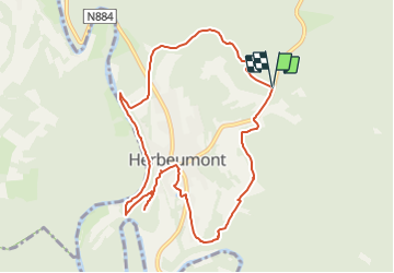
Trail Walking of 9.5 km to be discovered at Wallonia, Luxembourg, Herbeumont. This trail is proposed by ed1769.
Description
Very pretty walk to the village of Herbeumont - then long path along the Semois
Visit of the castle d'Herbeumont ( free )
Return by a mountain path to the cottage
Positioning
Country:
Belgium
Region :
Wallonia
Department/Province :
Luxembourg
Municipality :
Herbeumont
Location:
Unknown
Start:(Dec)
Start:(UTM)
662153 ; 5517587 (31U) N.
Comments
Trails nearby
![Trail Other activity Bertrix - BX08 - Photo](https://media.geolcdn.com/t/375/260/ext.jpg?maxdim=2&url=https%3A%2F%2Fstatic1.geolcdn.com%2Fsiteimages%2Fupload%2Ffiles%2F1545311037marcheuse_200dpi.jpg)
![Other activity Other activity](https://static1.geolcdn.com/sitytour/trail-icons/900.png)
BX08
Other activity
Very easy
(9)
Bertrix,
Wallonia,
Luxembourg,
Belgium
![](/images/other/stat-length.png)
7.3 km | 10 km-effort
2h 30min
![](https://static1.geolcdn.com/siteimages/upload/files/16400158638029165_repeat_loop_refresh_sync_direction_icon.png)
Yes
![Walking Walking](https://static1.geolcdn.com/sitytour/trail-icons/101.png)
RB-Lu-23_Herbeumont_via-racc-1-et-var
Walking
Very difficult
(4)
Herbeumont,
Wallonia,
Luxembourg,
Belgium
![](/images/other/stat-length.png)
18.6 km | 25 km-effort
5h 44min
![](https://static1.geolcdn.com/siteimages/upload/files/16400158638029165_repeat_loop_refresh_sync_direction_icon.png)
Yes
![Walking Walking](https://static1.geolcdn.com/sitytour/trail-icons/101.png)
RB-Lu-23_Herbeumont
Walking
Difficult
(2)
Herbeumont,
Wallonia,
Luxembourg,
Belgium
![](/images/other/stat-length.png)
26 km | 35 km-effort
7h 26min
![](https://static1.geolcdn.com/siteimages/upload/files/16400158638029165_repeat_loop_refresh_sync_direction_icon.png)
Yes
![Trail Walking Bertrix - Bertrix arboretum - Photo](https://media.geolcdn.com/t/375/260/aec43457-0ac5-47ef-8414-fdada4cc2fd7.jpg&format=jpg&maxdim=2)
![Walking Walking](https://static1.geolcdn.com/sitytour/trail-icons/101.png)
Bertrix arboretum
Walking
Very difficult
(1)
Bertrix,
Wallonia,
Luxembourg,
Belgium
![](/images/other/stat-length.png)
16.3 km | 22 km-effort
3h 10min
![](https://static1.geolcdn.com/siteimages/upload/files/16400158638029165_repeat_loop_refresh_sync_direction_icon.png)
Yes
![Walking Walking](https://static1.geolcdn.com/sitytour/trail-icons/101.png)
Marche Adeps 10 km
Walking
Difficult
(6)
Herbeumont,
Wallonia,
Luxembourg,
Belgium
![](/images/other/stat-length.png)
9.1 km | 12.6 km-effort
2h 51min
![](https://static1.geolcdn.com/siteimages/upload/files/16400158638029165_repeat_loop_refresh_sync_direction_icon.png)
Yes
![Trail Walking Florenville - rando les epioux 15/09/2020 - Photo](https://media.geolcdn.com/t/375/260/f418135f-9d94-414f-b063-7d7f558c9ced.jpg&format=jpg&maxdim=2)
![Walking Walking](https://static1.geolcdn.com/sitytour/trail-icons/101.png)
rando les epioux 15/09/2020
Walking
Very easy
(1)
Florenville,
Wallonia,
Luxembourg,
Belgium
![](/images/other/stat-length.png)
18.1 km | 23 km-effort
4h 7min
![](https://static1.geolcdn.com/siteimages/upload/files/16400158638029165_repeat_loop_refresh_sync_direction_icon.png)
Yes
![Trail Walking Florenville - 14km St Cécile vers Herbeumont - Photo](https://media.geolcdn.com/t/375/260/ext.jpg?maxdim=2&url=https%3A%2F%2Fservices.sitytrail.com%2FGeolivesWS%2FDownloadMedia.ashx%3FTrailID%3D1023598%26Media%3Dfix__20180817123348.jpg)
![Walking Walking](https://static1.geolcdn.com/sitytour/trail-icons/101.png)
14km St Cécile vers Herbeumont
Walking
Medium
(1)
Florenville,
Wallonia,
Luxembourg,
Belgium
![](/images/other/stat-length.png)
14 km | 18.1 km-effort
2h 56min
![](https://static1.geolcdn.com/siteimages/upload/files/16400158638029165_repeat_loop_refresh_sync_direction_icon.png)
Yes
![Trail Walking Herbeumont - RSIH - Herbeumont - Les Épioux - Photo](https://media.geolcdn.com/t/375/260/ca0e741e-0f45-4c3d-9414-5f2e5834b9ce.jpg&format=jpg&maxdim=2)
![Walking Walking](https://static1.geolcdn.com/sitytour/trail-icons/101.png)
RSIH - Herbeumont - Les Épioux
Walking
Difficult
(1)
Herbeumont,
Wallonia,
Luxembourg,
Belgium
![](/images/other/stat-length.png)
14.8 km | 19.2 km-effort
4h 21min
![](https://static1.geolcdn.com/siteimages/upload/files/16400158638029165_repeat_loop_refresh_sync_direction_icon.png)
Yes
![Trail Walking Herbeumont - Les Burzais - départ du gite Le bout des bois - Photo](https://media.geolcdn.com/t/375/260/ext.jpg?maxdim=2&url=https%3A%2F%2Fservices.sitytrail.com%2FGeolivesWS%2FDownloadMedia.ashx%3FTrailID%3D419104%26Media%3Dfix__20140609121902.jpg)
![Walking Walking](https://static1.geolcdn.com/sitytour/trail-icons/101.png)
Les Burzais - départ du gite Le bout des bois
Walking
Medium
(3)
Herbeumont,
Wallonia,
Luxembourg,
Belgium
![](/images/other/stat-length.png)
4.2 km | 5.9 km-effort
1h 30min
![](https://static1.geolcdn.com/siteimages/upload/files/16400158638029165_repeat_loop_refresh_sync_direction_icon.png)
Yes
heel mooie gevarieerde wandeling met af en toe een stevig klimmetje. geen enkele auto tegen gekomen onderweg.