![](/images/other/stat-length.png)
![Trail Walking Méry-sur-Seine - de MÉRY SUR SEINE aux ÉTANGS de BRUN - Photo](https://media.geolcdn.com/t/1900/400/ext.pjpeg?maxdim=2&url=https%3A%2F%2Fmedia.geolcdn.com%2Ff%2F015e7e47-d60f-4ae8-b046-69106a976829.jpg)
de MÉRY SUR SEINE aux ÉTANGS de BRUN
jeannine grandjean
User
![Length](/images/other/stat-length.png)
Length
9.4 km
![Max alt](https://static1.geolcdn.com/siteimages/upload/files/1508320355ic_sort_altitude_max_24dp.png)
Max alt
86 m
![Uphill gradient](https://static1.geolcdn.com/siteimages/upload/files/1508320355ic_sort_den_pos_24dp.png)
Uphill gradient
38 m
![Km-Effort](/images/other/stat-length.png)
Km-Effort
9.9 km
![Min alt](https://static1.geolcdn.com/siteimages/upload/files/1508320355ic_sort_altitude_min_24dp.png)
Min alt
77 m
![Downhill gradient](https://static1.geolcdn.com/siteimages/upload/files/1508320355ic_sort_den_neg_24dp.png)
Downhill gradient
37 m
![Boucle](https://static1.geolcdn.com/siteimages/upload/files/16400158638029165_repeat_loop_refresh_sync_direction_icon.png)
Boucle
Yes
Creation date :
2022-01-01 09:28:59.976
Updated on :
2022-01-18 09:17:47.399
![Walking](https://static1.geolcdn.com/sitytour/trail-icons/101.png)
2h25
Difficulty : Very easy
![Scan this QR Code to open this trail in the SityTrail application](https://capi.geolives.com/qq0zvz2zws4bq2lad0pu/sitytour/trails/3038391/qr.png?size=200)
FREE GPS app for hiking
About
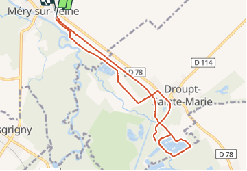
Trail Walking of 9.4 km to be discovered at Grand Est, Aube, Méry-sur-Seine. This trail is proposed by jeannine grandjean.
Description
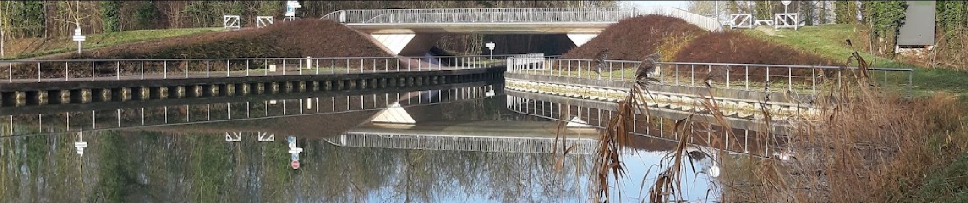
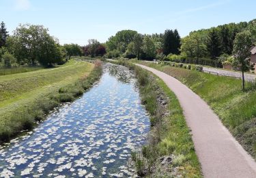
jolie randonnée au départ de Méry ; on suit le canal de la Haute-Seine sur la voie verte avant de rejoindre les étangs à travers bois. Retour par Droupt Sainte Marie puis vers Méry de l'autre côté du canal
Positioning
Country:
France
Region :
Grand Est
Department/Province :
Aube
Municipality :
Méry-sur-Seine
Location:
Unknown
Start:(Dec)
Start:(UTM)
566078 ; 5373019 (31U) N.
Comments
Trails nearby
![Trail Walking Méry-sur-Seine - entre Méry sur Seine et Saint-Oulph - Photo](https://media.geolcdn.com/t/375/260/ext.jpg?maxdim=2&url=https%3A%2F%2Fmedia.geolcdn.com%2Ff%2F0186bc20-54e5-4288-95d7-898530ed8516.jpg)
![Walking Walking](https://static1.geolcdn.com/sitytour/trail-icons/101.png)
entre Méry sur Seine et Saint-Oulph
Walking
Very easy
Méry-sur-Seine,
Grand Est,
Aube,
France
![](/images/other/stat-length.png)
6.4 km | 6.9 km-effort
1h 37min
![](https://static1.geolcdn.com/siteimages/upload/files/16400158638029165_repeat_loop_refresh_sync_direction_icon.png)
Yes
![Trail Walking Méry-sur-Seine - Boucle Mery sur Seine - Droupt-Saint-Basle - Photo](https://media.geolcdn.com/t/375/260/ext.jpg?maxdim=2&url=https%3A%2F%2Fmedia.geolcdn.com%2Ff%2F7c801274-e500-461e-b9ec-2940bacb5d77.jpg)
![Walking Walking](https://static1.geolcdn.com/sitytour/trail-icons/101.png)
Boucle Mery sur Seine - Droupt-Saint-Basle
Walking
Easy
Méry-sur-Seine,
Grand Est,
Aube,
France
![](/images/other/stat-length.png)
11.6 km | 12.2 km-effort
2h 17min
![](https://static1.geolcdn.com/siteimages/upload/files/16400158638029165_repeat_loop_refresh_sync_direction_icon.png)
Yes
![Trail Walking Droupt-Saint-Basle - Droupt, Rilly, écluse 8 - Photo](https://media.geolcdn.com/t/375/260/ext.jpg?maxdim=2&url=https%3A%2F%2Fmedia.geolcdn.com%2Ff%2F12d3cf9d-3bc5-4946-b230-821be03a4d7e.jpg)
![Walking Walking](https://static1.geolcdn.com/sitytour/trail-icons/101.png)
Droupt, Rilly, écluse 8
Walking
Easy
Droupt-Saint-Basle,
Grand Est,
Aube,
France
![](/images/other/stat-length.png)
17.8 km | 19.8 km-effort
4h 9min
![](https://static1.geolcdn.com/siteimages/upload/files/16400158638029165_repeat_loop_refresh_sync_direction_icon.png)
Yes
![Trail Walking Vallant-Saint-Georges - Boucle entre canal et champs - Photo](https://media.geolcdn.com/t/375/260/ext.jpg?maxdim=2&url=https%3A%2F%2Fmedia.geolcdn.com%2Ff%2Fb1c3463c-0b79-44f7-a51a-6fed128e16ac.jpg)
![Walking Walking](https://static1.geolcdn.com/sitytour/trail-icons/101.png)
Boucle entre canal et champs
Walking
Easy
Vallant-Saint-Georges,
Grand Est,
Aube,
France
![](/images/other/stat-length.png)
18.1 km | 0 m-effort
4h 7min
![](https://static1.geolcdn.com/siteimages/upload/files/16400158638029165_repeat_loop_refresh_sync_direction_icon.png)
Yes
![Trail Mountain bike Châtres - 221922 - Photo](https://media.geolcdn.com/t/375/260/ext.jpg?maxdim=2&url=https%3A%2F%2Fstatic1.geolcdn.com%2Fsiteimages%2Fupload%2Ffiles%2F1524743154velo.jpg)
![Mountain bike Mountain bike](https://static1.geolcdn.com/sitytour/trail-icons/202.png)
![Trail Road bike Méry-sur-Seine - ouf du soleil - Photo](https://media.geolcdn.com/t/375/260/ext.jpg?maxdim=2&url=https%3A%2F%2Fstatic1.geolcdn.com%2Fsiteimages%2Fupload%2Ffiles%2F1524743154velo.jpg)
![Road bike Road bike](https://static1.geolcdn.com/sitytour/trail-icons/201.png)
ouf du soleil
Road bike
Very difficult
Méry-sur-Seine,
Grand Est,
Aube,
France
![](/images/other/stat-length.png)
53 km | 56 km-effort
2h 59min
![](https://static1.geolcdn.com/siteimages/upload/files/16400158638029165_repeat_loop_refresh_sync_direction_icon.png)
Yes
![Trail Road bike Méry-sur-Seine - renard - Photo](https://media.geolcdn.com/t/375/260/ext.jpg?maxdim=2&url=https%3A%2F%2Fstatic1.geolcdn.com%2Fsiteimages%2Fupload%2Ffiles%2F1524743154velo.jpg)
![Road bike Road bike](https://static1.geolcdn.com/sitytour/trail-icons/201.png)
renard
Road bike
Very difficult
Méry-sur-Seine,
Grand Est,
Aube,
France
![](/images/other/stat-length.png)
51 km | 55 km-effort
3h 12min
![](https://static1.geolcdn.com/siteimages/upload/files/16400158638029165_repeat_loop_refresh_sync_direction_icon.png)
Yes
![Trail Walking Vallant-Saint-Georges - Vallant-Saint-Georges.(10) - Circuit à la découverte des 3 saints - Photo](https://media.geolcdn.com/t/375/260/ext.jpg?maxdim=2&url=https%3A%2F%2Fstatic1.geolcdn.com%2Fsiteimages%2Fupload%2Ffiles%2F1553511878bg_sport_marche.png)
![Walking Walking](https://static1.geolcdn.com/sitytour/trail-icons/101.png)
Vallant-Saint-Georges.(10) - Circuit à la découverte des 3 saints
Walking
Difficult
Vallant-Saint-Georges,
Grand Est,
Aube,
France
![](/images/other/stat-length.png)
15.8 km | 16.9 km-effort
3h 50min
![](https://static1.geolcdn.com/siteimages/upload/files/16400158638029165_repeat_loop_refresh_sync_direction_icon.png)
Yes
![Trail Mountain bike Châtres - flotte oulph - Photo](https://media.geolcdn.com/t/375/260/ext.jpg?maxdim=2&url=https%3A%2F%2Fstatic1.geolcdn.com%2Fsiteimages%2Fupload%2Ffiles%2F1524743154velo.jpg)
![Mountain bike Mountain bike](https://static1.geolcdn.com/sitytour/trail-icons/202.png)