Trail Running Cholet - Bois Lavau Choletais - Photo
© OpenStreetMap contributors
Length
Length
6.2 km
Max alt
Max alt
139 m
Uphill gradient
Uphill gradient
55 m
Km-Effort
Km-Effort  
6.9 km
Min alt
Min alt
112 m
Downhill gradient
Downhill gradient
55 m
Boucle
Boucle
Yes
Creation date :
2022-01-01 09:26:55.0
Updated on :
2022-01-01 10:20:55.288

(0 Reviews)

Running
Running
53m
Difficulty : Very easy

Scan this QR Code to open this trail in the SityTrail application

FREE GPS app for hiking

Logo SityTrail SityTrail

IGN / Geographical institutes

Download SityTrail from the App Store Download SityTrail from Google Play

Logo SityTrail SityTrail World

The world is yours!

Download SityTrail from the App Store Download SityTrail from Google Play Download SityTrail on Huawei AppGallery

About

Trail Running of 6.2 km to be discovered at Pays de la Loire, Maine-et-Loire, Cholet. This trail is proposed by Baptiste L..

Elevation profile

Positioning

Country:
France
Region :
Pays de la Loire
Department/Province :
Maine-et-Loire
Municipality :
Cholet
Location:
Cholet
Start:(UTM)
661144 ; 5214690 (30T) N.

Trails nearby

Trail Other activity Cholet - Cholet-Nantes - Photo
Other activity
st141230

Other activity

Very easy
(2)
Cholet, Pays de la Loire, Maine-et-Loire, France
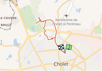
78 km | 86 km-effort
Unknown
No
Trail On foot Cholet - La Ribou'cle - Photo
On foot
PRO

On foot

Easy
Cholet, Pays de la Loire, Maine-et-Loire, France
10.9 km | 12.4 km-effort
2h 48min
Yes
Trail Walking La Tessoualle - MAINE ET LOIRE: TOUR DU LAC DE RIBOU - Photo
Walking
djeepee74

Walking

Easy
La Tessoualle, Pays de la Loire, Maine-et-Loire, France
11.3 km | 12.8 km-effort
3h 30min
Yes
Trail Running Cholet - Autour de Cholet - Photo
Running
tracegps

Running

Medium
Cholet, Pays de la Loire, Maine-et-Loire, France
11.9 km | 13.5 km-effort
1h 15min
Yes
Trail Walking Cholet - Autour de Cholet - Photo
Walking
tracegps

Walking

Medium
Cholet, Pays de la Loire, Maine-et-Loire, France
11.9 km | 13.5 km-effort
2h 30min
Yes
Trail Cycle Mazières-en-Mauges - 2012-07-02 Mazieres - Étang des Noues - Peronne  - Photo
Cycle
cagouille79

Cycle

Easy
Mazières-en-Mauges, Pays de la Loire, Maine-et-Loire, France
28 km | 31 km-effort
3h 4min
Yes
Trail Mountain bike La Séguinière - La Séguinière 2023 - Photo
Mountain bike
pates_au_chaud

Mountain bike

Difficult
La Séguinière, Pays de la Loire, Maine-et-Loire, France
36 km | 42 km-effort
3h 54min
Yes
Trail Mountain bike La Séguinière - La Séguinière 2022 - Photo
Mountain bike
pates_au_chaud

Mountain bike

Difficult
La Séguinière, Pays de la Loire, Maine-et-Loire, France
32 km | 36 km-effort
2h 51min
Yes
Trail Walking La Tessoualle - tour du lac de Ribou - Photo
Walking
lmrcho49

Walking

Very easy
(2)
La Tessoualle, Pays de la Loire, Maine-et-Loire, France
11.3 km | 12.7 km-effort
2h 54min
Yes


Close
My subscriptions