Trail Nordic walking Shefford - Mont Shefford - Photo
© OpenStreetMap contributors
Length
Length
4.4 km
Max alt
Max alt
478 m
Uphill gradient
Uphill gradient
175 m
Km-Effort
Km-Effort  
6.7 km
Min alt
Min alt
313 m
Downhill gradient
Downhill gradient
178 m
Boucle
Boucle
Yes
Creation date :
2021-12-31 14:49:22.901
Updated on :
2021-12-31 15:54:25.553

(0 Reviews)

Nordic walking
Nordic walking
1h02
Difficulty : Easy

Scan this QR Code to open this trail in the SityTrail application

FREE GPS app for hiking

Logo SityTrail SityTrail

IGN / Geographical institutes

Download SityTrail from the App Store Download SityTrail from Google Play

Logo SityTrail SityTrail World

The world is yours!

Download SityTrail from the App Store Download SityTrail from Google Play Download SityTrail on Huawei AppGallery

About

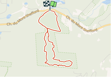
Trail Nordic walking of 4.4 km to be discovered at Quebec, La Haute-Yamaska, Shefford. This trail is proposed by Phil Paquet.

Elevation profile

Positioning

Country:
Canada
Region :
Quebec
Department/Province :
La Haute-Yamaska
Municipality :
Shefford
Location:
Unknown
Start:(UTM)
687957 ; 5025465 (18T) N.

Trails nearby

Trail Road bike Roxton Pond - Trail Planner Map - Photo
Road bike
GUIDE
Alizée.pee

Road bike

Medium
Roxton Pond, Quebec, La Haute-Yamaska, Canada
18 km | 21 km-effort
1h 13min
Yes
Trail Canoe - kayak Roxton Pond - Lac Yamaska - Photo
Canoe - kayak
DaVinci

Canoe - kayak

Medium
Roxton Pond, Quebec, La Haute-Yamaska, Canada
15.2 km | 15.9 km-effort
2h 35min
Yes


Close
My subscriptions