Trail Walking Loisy-sur-Marne - Loisy - Photo
 JD51290
JD51290

User

© OpenStreetMap contributors
Length
Length
13.2 km
Max alt
Max alt
151 m
Uphill gradient
Uphill gradient
95 m
Km-Effort
Km-Effort  
14.4 km
Min alt
Min alt
89 m
Downhill gradient
Downhill gradient
89 m
Boucle
Boucle
No
Creation date :
2014-12-10 00:00:00.0
Updated on :
2014-12-10 00:00:00.0

(1 Reviews)

Walking
Walking
3h00
Difficulty : Unknown

Scan this QR Code to open this trail in the SityTrail application

FREE GPS app for hiking

Logo SityTrail SityTrail

IGN / Geographical institutes

Download SityTrail from the App Store Download SityTrail from Google Play

Logo SityTrail SityTrail World

The world is yours!

Download SityTrail from the App Store Download SityTrail from Google Play Download SityTrail on Huawei AppGallery

About

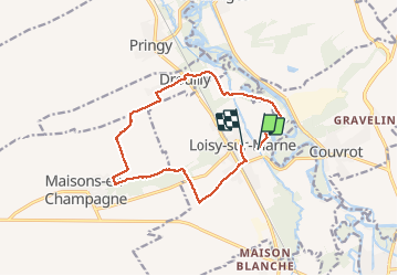
Trail Walking of 13.2 km to be discovered at Grand Est, Marne, Loisy-sur-Marne. This trail is proposed by JD51290.

Elevation profile

Positioning

Country:
France
Region :
Grand Est
Department/Province :
Marne
Municipality :
Loisy-sur-Marne
Location:
Unknown
Start:(UTM)
613843 ; 5401745 (31U) N.

Comments

Please log in to post a review or rate the element


Merci pour ce bon Moment


Trails nearby

Trail Walking Vitry-le-François - La Via Francigena - Vitry le François - Brienne le Château - Photo
Walking
tracegps

Walking

Medium
(1)
Vitry-le-François, Grand Est, Marne, France
79 km | 89 km-effort
16h 0min
No
Trail On foot Loisy-sur-Marne - Parcours Violet - Photo
On foot
PRO

On foot

Easy
Loisy-sur-Marne, Grand Est, Marne, France
4.8 km | 5.3 km-effort
1h 11min
Yes
Trail On foot Loisy-sur-Marne - Parcours Vert - Photo
On foot
PRO

On foot

Easy
Loisy-sur-Marne, Grand Est, Marne, France
5.4 km | 5.8 km-effort
1h 19min
Yes
Trail On foot Loisy-sur-Marne - Parcours Rouge - Photo
On foot
PRO

On foot

Easy
Loisy-sur-Marne, Grand Est, Marne, France
10.6 km | 11.7 km-effort
2h 39min
No
Trail On foot Loisy-sur-Marne - Parcours Rose - Photo
On foot
PRO

On foot

Easy
Loisy-sur-Marne, Grand Est, Marne, France
4.7 km | 4.9 km-effort
1h 7min
No
Trail On foot Loisy-sur-Marne - Parcours Bleu - Photo
On foot
PRO

On foot

Easy
Loisy-sur-Marne, Grand Est, Marne, France
6.8 km | 7.2 km-effort
1h 38min
No
Trail Walking Vitry-le-François - Chemin de Compostelle, Voie de Vézelay GR654® De Vitry le François à Saint Rémy en Bouzemont - Photo
Walking
tracegps

Walking

Medium
Vitry-le-François, Grand Est, Marne, France
21 km | 24 km-effort
4h 10min
No
Trail Bicycle tourism Vitry-le-François - Canal Marne au Rhin Vélo 363 km - Photo
Bicycle tourism
GUIDE
jeanmarcMasson

Bicycle tourism

Very difficult
Vitry-le-François, Grand Est, Marne, France
363 km | 400 km-effort
Unknown
No
Trail Bicycle tourism Vitry-le-François - Canal Marne au Rhin Vélo 1 - Photo
Bicycle tourism
GUIDE
jeanmarcMasson

Bicycle tourism

Very difficult
Vitry-le-François, Grand Est, Marne, France
308 km | 339 km-effort
Unknown
No


Close
My subscriptions