![](/images/other/stat-length.png)
![Trail Walking Ronse - Taalgrenswandelroute - Photo](https://media.geolcdn.com/t/1900/400/43b0db83-e490-4533-8b25-00901a795013.jpg&format=pjpeg&maxdim=2)
Taalgrenswandelroute
Jan Coddens
User
![Length](/images/other/stat-length.png)
Length
36 km
![Max alt](https://static1.geolcdn.com/siteimages/upload/files/1508320355ic_sort_altitude_max_24dp.png)
Max alt
162 m
![Uphill gradient](https://static1.geolcdn.com/siteimages/upload/files/1508320355ic_sort_den_pos_24dp.png)
Uphill gradient
638 m
![Km-Effort](/images/other/stat-length.png)
Km-Effort
45 km
![Min alt](https://static1.geolcdn.com/siteimages/upload/files/1508320355ic_sort_altitude_min_24dp.png)
Min alt
34 m
![Downhill gradient](https://static1.geolcdn.com/siteimages/upload/files/1508320355ic_sort_den_neg_24dp.png)
Downhill gradient
638 m
![Boucle](https://static1.geolcdn.com/siteimages/upload/files/16400158638029165_repeat_loop_refresh_sync_direction_icon.png)
Boucle
Yes
Creation date :
2021-12-20 07:25:23.781
Updated on :
2021-12-20 07:28:03.908
![Walking](https://static1.geolcdn.com/sitytour/trail-icons/101.png)
10h09
Difficulty : Very difficult
![Scan this QR Code to open this trail in the SityTrail application](https://capi.geolives.com/qq0zvz2zws4bq2lad0pu/sitytour/trails/3030509/qr.png?size=200)
FREE GPS app for hiking
About
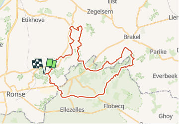
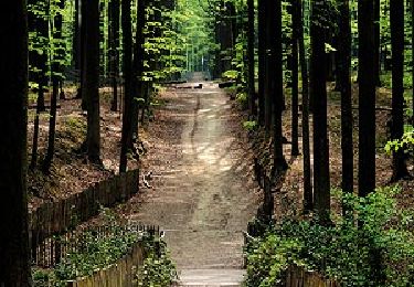
Trail Walking of 36 km to be discovered at Flanders, East Flanders, Ronse. This trail is proposed by Jan Coddens.
Description
De Taalgrenswandelroute is voor de stevige stappers onder ons. Je wandelt 36,2 kilometer langs de taalgrens over de heuvels van de Vlaamse Ardennen.
Points of interest
Positioning
Country:
Belgium
Region :
Flanders
Department/Province :
East Flanders
Municipality :
Ronse
Location:
Unknown
Start:(Dec)
Start:(UTM)
545250 ; 5623854 (31U) N.
Comments
Trails nearby
![Trail Walking Ellezelles - RB-Ha-02 - Ellezelles - 2024-10-29 - Photo](https://media.geolcdn.com/t/375/260/ext.jpg?maxdim=2&url=https%3A%2F%2Fservices.sitytrail.com%2FGeolivesWS%2FDownloadMedia.ashx%3FTrailID%3D217832%26Media%3D2f63cbc9-67e0-4d65-89f9-544523dd5718.jpg)
![Walking Walking](https://static1.geolcdn.com/sitytour/trail-icons/101.png)
RB-Ha-02 - Ellezelles - 2024-10-29
Walking
Very difficult
(4)
Ellezelles,
Wallonia,
Hainaut,
Belgium
![](/images/other/stat-length.png)
17.9 km | 22 km-effort
4h 56min
![](https://static1.geolcdn.com/siteimages/upload/files/16400158638029165_repeat_loop_refresh_sync_direction_icon.png)
Yes
![Trail Electric bike Ronse - Ellezelles par petits chemins pittoresques - Photo](https://media.geolcdn.com/t/375/260/e0aa3d15-f60d-4f83-a5a3-a0f3e8c9900b.jpg&format=jpg&maxdim=2)
![Electric bike Electric bike](https://static1.geolcdn.com/sitytour/trail-icons/205.png)
Ellezelles par petits chemins pittoresques
Electric bike
Easy
(1)
Ronse,
Flanders,
East Flanders,
Belgium
![](/images/other/stat-length.png)
15.9 km | 18.7 km-effort
1h 22min
![](https://static1.geolcdn.com/siteimages/upload/files/16400158638029165_repeat_loop_refresh_sync_direction_icon.png)
Yes
![Trail Mountain bike Ronse - Vers Musiekbos - Photo](https://media.geolcdn.com/t/375/260/ext.jpg?maxdim=2&url=https%3A%2F%2Fservices.sitytrail.com%2FGeolivesWS%2FDownloadMedia.ashx%3FTrailID%3D412567%26Media%3Dfix__20150426141940.jpg)
![Mountain bike Mountain bike](https://static1.geolcdn.com/sitytour/trail-icons/202.png)
Vers Musiekbos
Mountain bike
Medium
(1)
Ronse,
Flanders,
East Flanders,
Belgium
![](/images/other/stat-length.png)
15.7 km | 18.6 km-effort
2h 1min
![](https://static1.geolcdn.com/siteimages/upload/files/16400158638029165_repeat_loop_refresh_sync_direction_icon.png)
No
![Trail Walking Ellezelles - Le sentier de l'étrange - Photo](https://media.geolcdn.com/t/375/260/ext.jpg?maxdim=2&url=https%3A%2F%2Fservices.sitytrail.com%2FGeolivesWS%2FDownloadMedia.ashx%3FTrailID%3D202842%26Media%3Dfd094432-4170-43a7-b091-423977983591.jpg)
![Walking Walking](https://static1.geolcdn.com/sitytour/trail-icons/101.png)
Le sentier de l'étrange
Walking
Very easy
(4)
Ellezelles,
Wallonia,
Hainaut,
Belgium
![](/images/other/stat-length.png)
5.4 km | 6.6 km-effort
Unknown
![](https://static1.geolcdn.com/siteimages/upload/files/16400158638029165_repeat_loop_refresh_sync_direction_icon.png)
Yes
![Trail On foot Maarkedal - Muziekboswandeling - Photo](https://media.geolcdn.com/t/375/260/fc075cd6-bf31-4841-9a67-11027de5cfbf.jpeg&format=jpg&maxdim=2)
![On foot On foot](https://static1.geolcdn.com/sitytour/trail-icons/100.png)
Muziekboswandeling
On foot
Easy
(1)
Maarkedal,
Flanders,
East Flanders,
Belgium
![](/images/other/stat-length.png)
10.2 km | 13.3 km-effort
3h 1min
![](https://static1.geolcdn.com/siteimages/upload/files/16400158638029165_repeat_loop_refresh_sync_direction_icon.png)
Yes
![Trail On foot Flobecq - Entre La Houppe et Bos Ter Rijst - Photo](https://media.geolcdn.com/t/375/260/ext.jpg?maxdim=2&url=https%3A%2F%2Fpivotmedia.tourismewallonie.be%2FANX-02-000EUQ%2FANX-02-000EUQ.jpg)
![On foot On foot](https://static1.geolcdn.com/sitytour/trail-icons/100.png)
Entre La Houppe et Bos Ter Rijst
On foot
Easy
Flobecq,
Wallonia,
Hainaut,
Belgium
![](/images/other/stat-length.png)
12.7 km | 15.5 km-effort
3h 30min
![](https://static1.geolcdn.com/siteimages/upload/files/16400158638029165_repeat_loop_refresh_sync_direction_icon.png)
Yes
![Trail Equestrian Ellezelles - Loop of Ellezelles - Photo](https://media.geolcdn.com/t/375/260/ext.jpg?maxdim=2&url=https%3A%2F%2Fpivotmedia.tourismewallonie.be%2FANX-02-020D-00MD%2FANX-02-020D-00MD.jpg)
![Equestrian Equestrian](https://static1.geolcdn.com/sitytour/trail-icons/300.png)
Loop of Ellezelles
Equestrian
Very easy
Ellezelles,
Wallonia,
Hainaut,
Belgium
![](/images/other/stat-length.png)
26 km | 30 km-effort
Unknown
![](https://static1.geolcdn.com/siteimages/upload/files/16400158638029165_repeat_loop_refresh_sync_direction_icon.png)
Yes
![Trail On foot Flobecq - Dans le Brakelbos - Photo](https://media.geolcdn.com/t/375/260/ext.jpg?maxdim=2&url=https%3A%2F%2Fpivotmedia.tourismewallonie.be%2FANX-02-000EUU%2FANX-02-000EUU.jpg)
![On foot On foot](https://static1.geolcdn.com/sitytour/trail-icons/100.png)
Dans le Brakelbos
On foot
Easy
Flobecq,
Wallonia,
Hainaut,
Belgium
![](/images/other/stat-length.png)
7.7 km | 10 km-effort
2h 16min
![](https://static1.geolcdn.com/siteimages/upload/files/16400158638029165_repeat_loop_refresh_sync_direction_icon.png)
Yes
![Trail On foot Ellezelles - Weird and Wonderful Trail - Photo](https://media.geolcdn.com/t/375/260/ext.jpg?maxdim=2&url=https%3A%2F%2Fpivotmedia.tourismewallonie.be%2FANX-02-04KY-00CN%2FANX-02-04KY-00CN.jpg)
![On foot On foot](https://static1.geolcdn.com/sitytour/trail-icons/100.png)
Weird and Wonderful Trail
On foot
Easy
(2)
Ellezelles,
Wallonia,
Hainaut,
Belgium
![](/images/other/stat-length.png)
5.4 km | 6.6 km-effort
1h 29min
![](https://static1.geolcdn.com/siteimages/upload/files/16400158638029165_repeat_loop_refresh_sync_direction_icon.png)
Yes