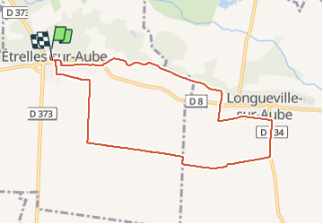
10.6 km | 11.3 km-effort
Boucle Etrelles dans les champs
NANE51
User
Length
8.8 km
Max alt
86 m
Uphill gradient
28 m
Km-Effort
9.2 km
Min alt
73 m
Downhill gradient
29 m
Boucle
Yes
Creation date :
2021-12-19 07:58:28.0
Updated on :
2021-12-19 09:43:46.269
1h44
Difficulty : Very easy
FREE GPS app for hiking
About
Trail Walking of 8.8 km to be discovered at Grand Est, Aube, Étrelles-sur-Aube. This trail is proposed by NANE51.
Description
Départ de l’église
Positioning
Country:
France
Region :
Grand Est
Department/Province :
Aube
Municipality :
Étrelles-sur-Aube
Location:
Unknown
Start:(Dec)
Start:(UTM)
564308 ; 5379023 (31U) N.
Comments
Trails nearby
Bagneux, les ruisseaux, les noues, la dérivation de l'Aube
Walking
Medium
Bagneux,
Grand Est,
Marne,
France
2h 40min
No
Au fil de l'Aube
Walking
Very easy
Anglure,
Grand Est,
Marne,
France
10.5 km | 11.2 km-effort
2h 7min
Yes
Boucle Etrelles Longueville
Walking
Medium
(1)
Étrelles-sur-Aube,
Grand Est,
Aube,
France
11.1 km | 11.7 km-effort
2h 14min
Yes
Boucle Bagneux Becheret Montahon
Walking
Bagneux,
Grand Est,
Marne,
France
9.6 km | 10.1 km-effort
1h 53min
No
Bagneux à Savières
Nordic walking
Medium
Bagneux,
Grand Est,
Marne,
France
28 km | 29 km-effort
6h 8min
No
Etrelles sur Aube 12 km
Walking
Difficult
Étrelles-sur-Aube,
Grand Est,
Aube,
France
11.8 km | 12.6 km-effort
2h 52min
Yes
Moret sur Loing / saint mammes
Walking
Very easy
Bagneux,
Grand Est,
Marne,
France
79 km | 87 km-effort
2h 20min
No