![](/images/other/stat-length.png)
![Trail Walking Deinze - Randonnée des Filliers à Deinze - Photo](https://media.geolcdn.com/t/1900/400/63489dac-74b1-4b82-bcac-292bc60f01cd.jpg&format=pjpeg&maxdim=2)
Randonnée des Filliers à Deinze
Au fil de nos découvertes
« L’heure de la fin des découvertes ne sonne jamais. » Colette GUIDE+
![Length](/images/other/stat-length.png)
![Max alt](https://static1.geolcdn.com/siteimages/upload/files/1508320355ic_sort_altitude_max_24dp.png)
![Uphill gradient](https://static1.geolcdn.com/siteimages/upload/files/1508320355ic_sort_den_pos_24dp.png)
![Km-Effort](/images/other/stat-length.png)
![Min alt](https://static1.geolcdn.com/siteimages/upload/files/1508320355ic_sort_altitude_min_24dp.png)
![Downhill gradient](https://static1.geolcdn.com/siteimages/upload/files/1508320355ic_sort_den_neg_24dp.png)
![Boucle](https://static1.geolcdn.com/siteimages/upload/files/16400158638029165_repeat_loop_refresh_sync_direction_icon.png)
![Walking](https://static1.geolcdn.com/sitytour/trail-icons/101.png)
1h44
Difficulty : Medium
![Scan this QR Code to open this trail in the SityTrail application](https://capi.geolives.com/qq0zvz2zws4bq2lad0pu/sitytour/trails/3028386/qr.png?size=200)
FREE GPS app for hiking
About
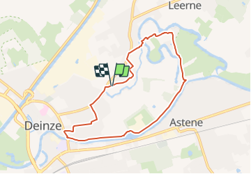
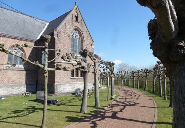
Trail Walking of 7 km to be discovered at Flanders, East Flanders, Deinze. This trail is proposed by Au fil de nos découvertes.
Description
🅿️ Départ et Parking:
Derrière l’usine Filliers
Leernsesteenweg 5,
9800 Deinze
⌚Boucle de /- 7km pour une durée de 1h30
🚶Niveau facile.
▶️ Suivre la balise « Filliers wandelroute »
Cependant, nous pensons que certaines balises ont été enlevées..
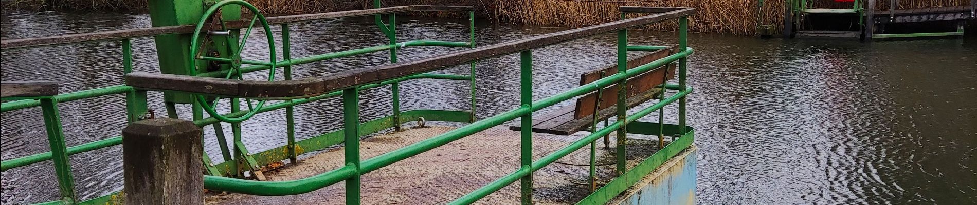
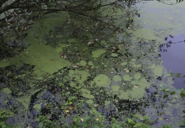
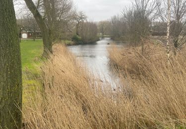
La promenade débute derrière l’usine Filliers et longe les champs. Vous traverserez l’eau, grâce au ferry à fonctionnement manuel.
Cette promenade assez paisible vous emmènera le long de la Lys.
Possibilités de pic-niquer. 🥪🍴
Chiens autorisés en laisse. 🐩🐶🐕
Convient pour les enfants . 👱👱♂️
Convient pour les poussettes et personnes à mobilité réduite. 👨🦽👩🦽👶
Bonne découverte !
N'hésitez pas à aller faire un tour sur notre site internet : www.aufildenosdecouvertes.com
Facebook :
https://www.facebook.com/Aufildenosdecouvertes
Instagram :
https://www.instagram.com/au_fil_de_nos_decouvertes
Positioning
Comments
Trails nearby
![Trail On foot Zulte - Roger Raveelroute - Photo](https://media.geolcdn.com/t/375/260/65215fcc-3c39-4b2f-8a5e-53236c2ada3d.jpeg&format=jpg&maxdim=2)
![On foot On foot](https://static1.geolcdn.com/sitytour/trail-icons/100.png)
On foot
![](/images/other/stat-length.png)
![](https://static1.geolcdn.com/siteimages/upload/files/16400158638029165_repeat_loop_refresh_sync_direction_icon.png)
![Trail On foot Deinze - Ooidonkroute - Photo](https://media.geolcdn.com/t/375/260/a989dc90-b267-4c71-9207-1c5a32844e07.jpeg&format=jpg&maxdim=2)
![On foot On foot](https://static1.geolcdn.com/sitytour/trail-icons/100.png)
On foot
![](/images/other/stat-length.png)
![](https://static1.geolcdn.com/siteimages/upload/files/16400158638029165_repeat_loop_refresh_sync_direction_icon.png)
![Trail On foot Zulte - Vlasrotersroute - Lus 1 - Photo](https://media.geolcdn.com/t/375/260/f3a30667-494e-4299-845d-44168b5304fd.jpeg&format=jpg&maxdim=2)
![On foot On foot](https://static1.geolcdn.com/sitytour/trail-icons/100.png)
On foot
![](/images/other/stat-length.png)
![](https://static1.geolcdn.com/siteimages/upload/files/16400158638029165_repeat_loop_refresh_sync_direction_icon.png)
![Trail Walking Zulte - Roger_Raveelwandelroute - Photo](https://media.geolcdn.com/t/375/260/ext.jpg?maxdim=2&url=https%3A%2F%2Fstatic1.geolcdn.com%2Fsiteimages%2Fupload%2Ffiles%2F1553511878bg_sport_marche.png)
![Walking Walking](https://static1.geolcdn.com/sitytour/trail-icons/101.png)
Walking
![](/images/other/stat-length.png)
![](https://static1.geolcdn.com/siteimages/upload/files/16400158638029165_repeat_loop_refresh_sync_direction_icon.png)
![Trail Walking Deinze - 19 km autour de Deinze et Machelen - Photo](https://media.geolcdn.com/t/375/260/f6f6d5b4-ad07-4d56-9b6b-e63ccbbcdac3.jpg&format=jpg&maxdim=2)
![Walking Walking](https://static1.geolcdn.com/sitytour/trail-icons/101.png)
Walking
![](/images/other/stat-length.png)
![](https://static1.geolcdn.com/siteimages/upload/files/16400158638029165_repeat_loop_refresh_sync_direction_icon.png)
![Trail Walking Deinze - Le château d’Ooidonk à Deinze - Photo](https://media.geolcdn.com/t/375/260/d255fdad-ee32-44cd-b7de-2c94d8b7f7ee.jpeg&format=jpg&maxdim=2)
![Walking Walking](https://static1.geolcdn.com/sitytour/trail-icons/101.png)
Walking
![](/images/other/stat-length.png)
![](https://static1.geolcdn.com/siteimages/upload/files/16400158638029165_repeat_loop_refresh_sync_direction_icon.png)
![Trail Walking Deinze - Filliers Deinze - Photo](https://media.geolcdn.com/t/375/260/e61df0b9-73c6-4e71-8315-6346762c2e63.jpg&format=jpg&maxdim=2)
![Walking Walking](https://static1.geolcdn.com/sitytour/trail-icons/101.png)
Walking
![](/images/other/stat-length.png)
![](https://static1.geolcdn.com/siteimages/upload/files/16400158638029165_repeat_loop_refresh_sync_direction_icon.png)
![Trail On foot Sint-Martens-Latem - Gust De Smet wandelroute - Photo](https://media.geolcdn.com/t/375/260/ext.jpg?maxdim=2&url=https%3A%2F%2Fstatic1.geolcdn.com%2Fsiteimages%2Fupload%2Ffiles%2F1545311037marcheuse_200dpi.jpg)
![On foot On foot](https://static1.geolcdn.com/sitytour/trail-icons/100.png)
On foot
![](/images/other/stat-length.png)
![](https://static1.geolcdn.com/siteimages/upload/files/16400158638029165_repeat_loop_refresh_sync_direction_icon.png)
![Trail Walking Deinze - GR 129 : Deinze > Oudenaarde - Photo](https://media.geolcdn.com/t/375/260/ext.jpg?maxdim=2&url=https%3A%2F%2Fstatic1.geolcdn.com%2Fsiteimages%2Fupload%2Ffiles%2F1553511878bg_sport_marche.png)
![Walking Walking](https://static1.geolcdn.com/sitytour/trail-icons/101.png)
Walking
![](/images/other/stat-length.png)
![](https://static1.geolcdn.com/siteimages/upload/files/16400158638029165_repeat_loop_refresh_sync_direction_icon.png)