Trail Snowshoes La Clusaz - La Bombardellaz - FR - Photo
 UDGI54
UDGI54

User

© OpenStreetMap contributors
Length
Length
8.2 km
Max alt
Max alt
1763 m
Uphill gradient
Uphill gradient
385 m
Km-Effort
Km-Effort  
13.4 km
Min alt
Min alt
1441 m
Downhill gradient
Downhill gradient
385 m
Boucle
Boucle
Yes
Creation date :
2021-12-14 18:55:08.674
Updated on :
2021-12-14 18:58:15.317

(0 Reviews)

Snowshoes
Snowshoes
--
Difficulty : Very easy

Scan this QR Code to open this trail in the SityTrail application

FREE GPS app for hiking

Logo SityTrail SityTrail

IGN / Geographical institutes

Download SityTrail from the App Store Download SityTrail from Google Play

Logo SityTrail SityTrail World

The world is yours!

Download SityTrail from the App Store Download SityTrail from Google Play Download SityTrail on Huawei AppGallery

About

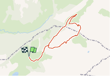
Trail Snowshoes of 8.2 km to be discovered at Auvergne-Rhône-Alpes, Upper Savoy, La Clusaz. This trail is proposed by UDGI54.

Description

Petite randonnée en alpage à la découverte des combes du Massif des Aravis et de leurs traditions. Suivant l’heure de la journée, vous apercevrez des chamois ou entendrez siffler les marmottes.Vous passerez au refuge de la Bombardellaz et au hameau du même nom avec ses anciennes habitations et son oratoire. Le soir, vous croiserez les chèvres qui rentrent pour la traite, après avoir pâturé l’herbe verte en haut des combes.

Départ : La Clusaz, Les Confins - Parking de l’Arpettaz

Elevation profile

Points of interest

Point of interest La Clusaz - Tourner à droite - Photo
UDGI54
Point of interest Le Grand-Bornand - Prendre le sentier de gauche qui descend - Photo
UDGI54
Point of interest Le Grand-Bornand - Refuge de la Bombardellaz altitude 1610 m, prendre le chemin à droite direction Chalets de la Bombardellaz - Photo
UDGI54
Point of interest Le Grand-Bornand - Chalets de la Bombardellaz altitude 1600 m, continuer sur le chemin direction Follières d'en Haut - Photo
UDGI54
Point of interest Le Grand-Bornand - Chalets de la Bombardellaz altitude 1590 m, prendre le sentier direction Pierre Marquée (Direct) - Photo
UDGI54
Point of interest Le Grand-Bornand - Hameau de La Bombardellaz : anciennes habitations et oratoire - Photo
UDGI54
Point of interest Le Grand-Bornand - La Pierre Marquée délimite, les communes de Grand Bornand et de la Clusaz. Cette pierre d’environ un mètre de long est datée de 1755. Elle marque la fin d’un conflit de près de 300 ans. - Photo
UDGI54
Point of interest Le Grand-Bornand - Pierre Marquée altitude 1537 m, prendre le chemin direction Chalet de Paccaly - Photo
UDGI54

Positioning

Country:
France
Region :
Auvergne-Rhône-Alpes
Department/Province :
Upper Savoy
Municipality :
La Clusaz
Location:
Unknown
Start:(UTM)
304885 ; 5088576 (32T) N.

Trails nearby

Trail Walking La Giettaz - Le Plan - col de Jaillet - Photo
Walking
wbarge

Walking

Medium
(2)
La Giettaz, Auvergne-Rhône-Alpes, Savoy, France
11.9 km | 19.7 km-effort
4h 18min
Yes
Trail Walking La Clusaz - 74.trou de la mouche la Clusaz août 2022 - Photo
Walking
GUIDE
randodyssée

Walking

Medium
La Clusaz, Auvergne-Rhône-Alpes, Upper Savoy, France
9.5 km | 24 km-effort
5h 32min
Yes
Trail Touring skiing Le Grand-Bornand - PT 2595au dessus du col des Verts - Photo
Touring skiing
GUIDE
nadd73

Touring skiing

Difficult
Le Grand-Bornand, Auvergne-Rhône-Alpes, Upper Savoy, France
14.2 km | 33 km-effort
5h 54min
Yes
Trail Mountain bike Le Grand-Bornand - vtt-dans-la-vallee-du-bouchet - Photo
Mountain bike
GUIDE
pascalou73

Mountain bike

Very easy
Le Grand-Bornand, Auvergne-Rhône-Alpes, Upper Savoy, France
7.5 km | 10.5 km-effort
Unknown
No
Trail Mountain bike Le Grand-Bornand - VTT du grand bornand au refuge - Photo
Mountain bike
GUIDE
pascalou73

Mountain bike

Very easy
Le Grand-Bornand, Auvergne-Rhône-Alpes, Upper Savoy, France
25 km | 38 km-effort
Unknown
Yes
Trail Mountain bike Le Grand-Bornand - Le_Grand_Bornand_20210706_104522 - Photo
Mountain bike
GUIDE
pascalou73

Mountain bike

Very easy
Le Grand-Bornand, Auvergne-Rhône-Alpes, Upper Savoy, France
18.4 km | 29 km-effort
Unknown
Yes
Trail Walking La Clusaz - Les Converses, Le Planet, Beauregard, les Corbassières (boucle) - Photo
Walking
GUIDE
lhomme.ph

Walking

Difficult
La Clusaz, Auvergne-Rhône-Alpes, Upper Savoy, France
10.4 km | 17.7 km-effort
3h 11min
Yes
Trail Walking Le Grand-Bornand - Refuge Gramusset à partir de la Duche - Photo
Walking
GUIDE
HERRY

Walking

Le Grand-Bornand, Auvergne-Rhône-Alpes, Upper Savoy, France
12.7 km | 23 km-effort
4h 32min
Yes
Trail Mountain bike Le Grand-Bornand - Le_Grand_Bornand_20200623_090207 - Photo
Mountain bike
GUIDE
pascalou73

Mountain bike

Very easy
Le Grand-Bornand, Auvergne-Rhône-Alpes, Upper Savoy, France
26 km | 38 km-effort
Unknown
No


Close
My subscriptions