![](/images/other/stat-length.png)
![Trail Walking Saint-Philippe - La Réunion - Le Piton de la Fournaise depuis le Pas de Bellecombe - Photo](https://media.geolcdn.com/t/1900/400/ext.pjpeg?maxdim=2&url=https%3A%2F%2Fservices.sitytrail.com%2FGeolivesWS%2FDownloadMedia.ashx%3FTrailID%3D302608%26Media%3Dfix__20140517130844.jpg)
La Réunion - Le Piton de la Fournaise depuis le Pas de Bellecombe
olive2b
User
![Length](/images/other/stat-length.png)
Length
6.5 km
![Max alt](https://static1.geolcdn.com/siteimages/upload/files/1508320355ic_sort_altitude_max_24dp.png)
Max alt
2494 m
![Uphill gradient](https://static1.geolcdn.com/siteimages/upload/files/1508320355ic_sort_den_pos_24dp.png)
Uphill gradient
171 m
![Km-Effort](/images/other/stat-length.png)
Km-Effort
9.3 km
![Min alt](https://static1.geolcdn.com/siteimages/upload/files/1508320355ic_sort_altitude_min_24dp.png)
Min alt
2211 m
![Downhill gradient](https://static1.geolcdn.com/siteimages/upload/files/1508320355ic_sort_den_neg_24dp.png)
Downhill gradient
330 m
![Boucle](https://static1.geolcdn.com/siteimages/upload/files/16400158638029165_repeat_loop_refresh_sync_direction_icon.png)
Boucle
No
Creation date :
2016-03-09 00:00:00.0
Updated on :
2016-03-09 00:00:00.0
![Walking](https://static1.geolcdn.com/sitytour/trail-icons/101.png)
1h34
Difficulty : Medium
![Scan this QR Code to open this trail in the SityTrail application](https://capi.geolives.com/qq0zvz2zws4bq2lad0pu/sitytour/trails/302608/qr.png?size=200)
FREE GPS app for hiking
About
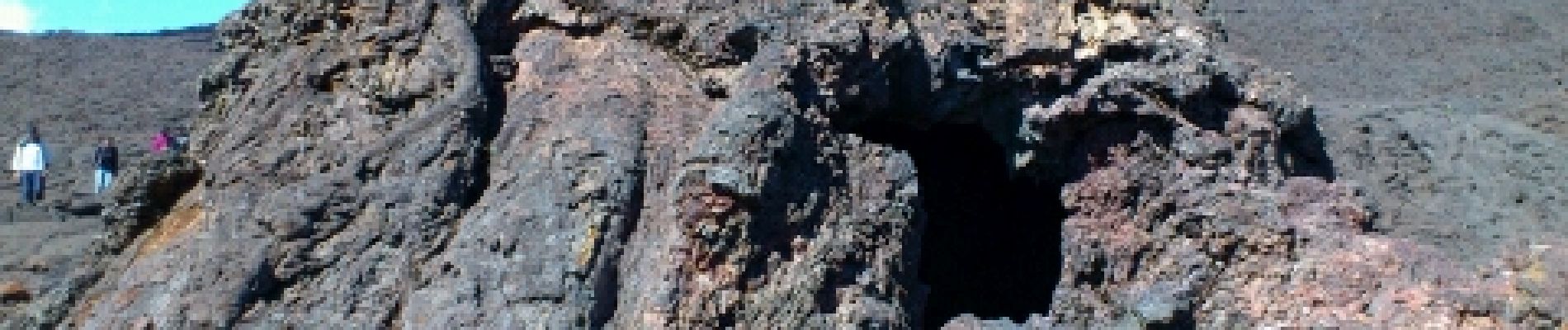
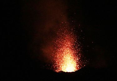
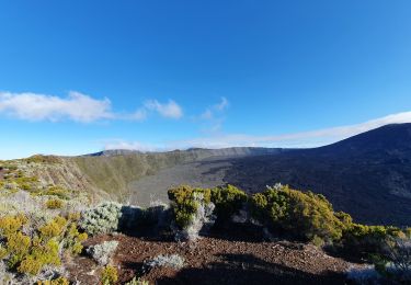
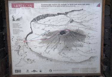
Trail Walking of 6.5 km to be discovered at Réunion, Unknown, Saint-Philippe. This trail is proposed by olive2b.
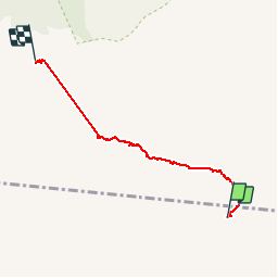
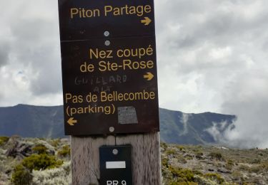
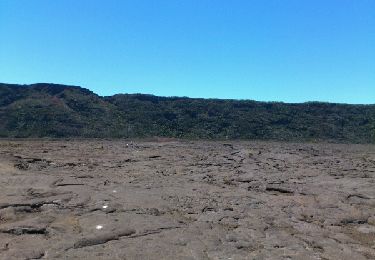
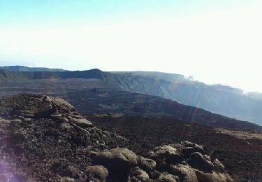
Description
Trajet retour.
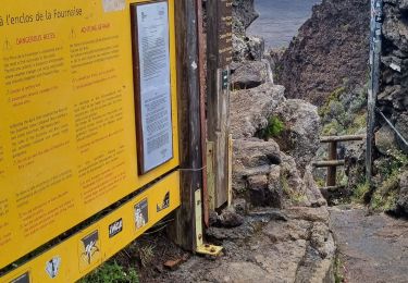
Le retour sur le Pas de Bellecombe par les marches est plus dur.
Le GPS a coupé sur le trajet la Chapelle Rosemont et le début des marches (bas) du Pas de Bellecombe.
Positioning
Country:
France
Region :
Réunion
Department/Province :
Unknown
Municipality :
Saint-Philippe
Location:
Unknown
Start:(Dec)
Start:(UTM)
367119 ; 7650146 (40K) S.
Comments
Trails nearby
![Trail Other activity Sainte-Rose - La Réunion - Le volcan - Nez Coupé par le parking Fo-Foc - Photo](https://media.geolcdn.com/t/375/260/ext.jpg?maxdim=2&url=https%3A%2F%2Fservices.sitytrail.com%2FGeolivesWS%2FDownloadMedia.ashx%3FTrailID%3D426183%26Media%3Dff873c16-0787-42fc-9f98-94c57e33fd00.jpg)
![Other activity Other activity](https://static1.geolcdn.com/sitytour/trail-icons/900.png)
La Réunion - Le volcan - Nez Coupé par le parking Fo-Foc
Other activity
Medium
(1)
Sainte-Rose,
Réunion,
Unknown,
France
![](/images/other/stat-length.png)
11.4 km | 13.7 km-effort
3h 17min
![](https://static1.geolcdn.com/siteimages/upload/files/16400158638029165_repeat_loop_refresh_sync_direction_icon.png)
No
![Trail Walking Sainte-Rose - La Réunion - Éruption de mai 2015 - Photo](https://media.geolcdn.com/t/375/260/ext.jpg?maxdim=2&url=https%3A%2F%2Fservices.sitytrail.com%2FGeolivesWS%2FDownloadMedia.ashx%3FTrailID%3D423857%26Media%3D1997df35-8592-4904-8fe0-7d403b4649c0.jpg)
![Walking Walking](https://static1.geolcdn.com/sitytour/trail-icons/101.png)
La Réunion - Éruption de mai 2015
Walking
Easy
(1)
Sainte-Rose,
Réunion,
Unknown,
France
![](/images/other/stat-length.png)
8.9 km | 10.5 km-effort
2h 15min
![](https://static1.geolcdn.com/siteimages/upload/files/16400158638029165_repeat_loop_refresh_sync_direction_icon.png)
No
![Trail Walking Sainte-Rose - bellecombe dolomieu - Photo](https://media.geolcdn.com/t/375/260/b964e988-94a2-455e-bcf2-5f36c3a573c3.jpg&format=jpg&maxdim=2)
![Walking Walking](https://static1.geolcdn.com/sitytour/trail-icons/101.png)
bellecombe dolomieu
Walking
Difficult
Sainte-Rose,
Réunion,
Unknown,
France
![](/images/other/stat-length.png)
15.2 km | 24 km-effort
6h 6min
![](https://static1.geolcdn.com/siteimages/upload/files/16400158638029165_repeat_loop_refresh_sync_direction_icon.png)
No
![Trail Walking Sainte-Rose - La Réunion - Boucle du point de vue du château Fort par le Pas de Bellecombe - Photo](https://media.geolcdn.com/t/375/260/ext.jpg?maxdim=2&url=https%3A%2F%2Fservices.sitytrail.com%2FGeolivesWS%2FDownloadMedia.ashx%3FTrailID%3D367178%26Media%3Dfix__20141203124320.jpg)
![Walking Walking](https://static1.geolcdn.com/sitytour/trail-icons/101.png)
La Réunion - Boucle du point de vue du château Fort par le Pas de Bellecombe
Walking
Medium
Sainte-Rose,
Réunion,
Unknown,
France
![](/images/other/stat-length.png)
16.6 km | 23 km-effort
6h 24min
![](https://static1.geolcdn.com/siteimages/upload/files/16400158638029165_repeat_loop_refresh_sync_direction_icon.png)
Yes
![Trail Walking Sainte-Rose - La Réunion - Le Piton de la Fournaise depuis le Pas de Bellecombe - Photo](https://media.geolcdn.com/t/375/260/ext.jpg?maxdim=2&url=https%3A%2F%2Fservices.sitytrail.com%2FGeolivesWS%2FDownloadMedia.ashx%3FTrailID%3D319341%26Media%3Dfix__20140517090719.jpg)
![Walking Walking](https://static1.geolcdn.com/sitytour/trail-icons/101.png)
La Réunion - Le Piton de la Fournaise depuis le Pas de Bellecombe
Walking
Medium
(2)
Sainte-Rose,
Réunion,
Unknown,
France
![](/images/other/stat-length.png)
7.9 km | 12.2 km-effort
3h 1min
![](https://static1.geolcdn.com/siteimages/upload/files/16400158638029165_repeat_loop_refresh_sync_direction_icon.png)
No
![Trail Walking Sainte-Rose - jour 11 montée Fournaise. - Photo](https://media.geolcdn.com/t/375/260/43e5ffb6-f820-4023-b789-21a055b65f06.jpg&format=jpg&maxdim=2)
![Walking Walking](https://static1.geolcdn.com/sitytour/trail-icons/101.png)
jour 11 montée Fournaise.
Walking
Medium
Sainte-Rose,
Réunion,
Unknown,
France
![](/images/other/stat-length.png)
10.3 km | 16.6 km-effort
5h 0min
![](https://static1.geolcdn.com/siteimages/upload/files/16400158638029165_repeat_loop_refresh_sync_direction_icon.png)
Yes
![Trail Walking Sainte-Rose - Piton de Bert - Photo](https://media.geolcdn.com/t/375/260/ded975ba-b953-47a8-92a1-1a17d305b689.jpg&format=jpg&maxdim=2)
![Walking Walking](https://static1.geolcdn.com/sitytour/trail-icons/101.png)
![Trail Walking Sainte-Rose - Piton de la Fournaise (cratère Dolomieu) - Piton Partage - Photo](https://media.geolcdn.com/t/375/260/57009959-25e5-4fe2-8997-582f8ade2fcd.jpg&format=jpg&maxdim=2)
![Walking Walking](https://static1.geolcdn.com/sitytour/trail-icons/101.png)
Piton de la Fournaise (cratère Dolomieu) - Piton Partage
Walking
Difficult
Sainte-Rose,
Réunion,
Unknown,
France
![](/images/other/stat-length.png)
16.2 km | 25 km-effort
5h 28min
![](https://static1.geolcdn.com/siteimages/upload/files/16400158638029165_repeat_loop_refresh_sync_direction_icon.png)
Yes
![Trail Walking Sainte-Rose - Le Piton de la fournaise (aller) - Photo](https://media.geolcdn.com/t/375/260/1b0a7354-aea4-45d1-9d62-fbc7fa1466fb.jpg&format=jpg&maxdim=2)
![Walking Walking](https://static1.geolcdn.com/sitytour/trail-icons/101.png)
Le Piton de la fournaise (aller)
Walking
Medium
Sainte-Rose,
Réunion,
Unknown,
France
![](/images/other/stat-length.png)
6.2 km | 10.1 km-effort
2h 4min
![](https://static1.geolcdn.com/siteimages/upload/files/16400158638029165_repeat_loop_refresh_sync_direction_icon.png)
No