![](/images/other/stat-length.png)
![Trail Nordic walking Amance - Champenoux (Bois d'Amance) 9 350m +115m - Photo](https://media.geolcdn.com/t/1900/400/ext.pjpeg?maxdim=2&url=https%3A%2F%2Fstatic1.geolcdn.com%2Fsiteimages%2Fupload%2Ffiles%2F1545311037marcheuse_200dpi.jpg)
Champenoux (Bois d'Amance) 9 350m +115m
DanielROLLET
User
![Length](/images/other/stat-length.png)
Length
9.3 km
![Max alt](https://static1.geolcdn.com/siteimages/upload/files/1508320355ic_sort_altitude_max_24dp.png)
Max alt
265 m
![Uphill gradient](https://static1.geolcdn.com/siteimages/upload/files/1508320355ic_sort_den_pos_24dp.png)
Uphill gradient
115 m
![Km-Effort](/images/other/stat-length.png)
Km-Effort
10.9 km
![Min alt](https://static1.geolcdn.com/siteimages/upload/files/1508320355ic_sort_altitude_min_24dp.png)
Min alt
225 m
![Downhill gradient](https://static1.geolcdn.com/siteimages/upload/files/1508320355ic_sort_den_neg_24dp.png)
Downhill gradient
115 m
![Boucle](https://static1.geolcdn.com/siteimages/upload/files/16400158638029165_repeat_loop_refresh_sync_direction_icon.png)
Boucle
Yes
Creation date :
2021-12-13 08:28:23.93
Updated on :
2021-12-13 15:55:59.6
![Nordic walking](https://static1.geolcdn.com/sitytour/trail-icons/102.png)
2h10
Difficulty : Easy
![Scan this QR Code to open this trail in the SityTrail application](https://capi.geolives.com/qq0zvz2zws4bq2lad0pu/sitytour/trails/3025190/qr.png?size=200)
FREE GPS app for hiking
About
Trail Nordic walking of 9.3 km to be discovered at Grand Est, Meurthe-et-Moselle, Amance. This trail is proposed by DanielROLLET.
Description
2021 12 13 - Marche nordique Saulxures Rando 54 - 21 participants.
Temps frais, brumeux et couvert mais calme
Marche modifiée cause chasseurs perte téléphone.
Trop d'arrêts
Positioning
Country:
France
Region :
Grand Est
Department/Province :
Meurthe-et-Moselle
Municipality :
Amance
Location:
Unknown
Start:(Dec)
Start:(UTM)
304573 ; 5403233 (32U) N.
Comments
Trails nearby
![Trail Walking Amance - Bouzule 13400m + 290m - Photo](https://media.geolcdn.com/t/375/260/ext.jpg?maxdim=2&url=https%3A%2F%2Fservices.sitytrail.com%2FGeolivesWS%2FDownloadMedia.ashx%3FTrailID%3D750365%26Media%3Dfix__20170510170945.jpg)
![Walking Walking](https://static1.geolcdn.com/sitytour/trail-icons/101.png)
Bouzule 13400m + 290m
Walking
Easy
Amance,
Grand Est,
Meurthe-et-Moselle,
France
![](/images/other/stat-length.png)
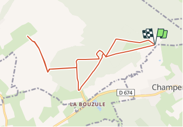
13.2 km | 16.9 km-effort
3h 41min
![](https://static1.geolcdn.com/siteimages/upload/files/16400158638029165_repeat_loop_refresh_sync_direction_icon.png)
Yes
![Trail Walking Amance - Brin - Photo](https://media.geolcdn.com/t/375/260/ext.jpg?maxdim=2&url=https%3A%2F%2Fservices.sitytrail.com%2FGeolivesWS%2FDownloadMedia.ashx%3FTrailID%3D389906%26Media%3Dfix__20150225142115.jpg)
![Walking Walking](https://static1.geolcdn.com/sitytour/trail-icons/101.png)
Brin
Walking
Easy
Amance,
Grand Est,
Meurthe-et-Moselle,
France
![](/images/other/stat-length.png)
11.4 km | 13.1 km-effort
2h 57min
![](https://static1.geolcdn.com/siteimages/upload/files/16400158638029165_repeat_loop_refresh_sync_direction_icon.png)
Yes
![Trail sport Réméréville - LM remereville - Photo](https://media.geolcdn.com/t/375/260/ext.jpg?maxdim=2&url=https%3A%2F%2Fsecurestorage.geolives.com%2Fsitytour%2Ftrail-bg%2Fdefault.jpg)
LM remereville
sport
Very easy
Réméréville,
Grand Est,
Meurthe-et-Moselle,
France
![](/images/other/stat-length.png)
11.1 km | 12.8 km-effort
Unknown
![](https://static1.geolcdn.com/siteimages/upload/files/16400158638029165_repeat_loop_refresh_sync_direction_icon.png)
Yes
![Trail Nordic walking Champenoux - Champenoux (muguet et asperges des bois) 7 900m +90m - Photo](https://media.geolcdn.com/t/375/260/ext.jpg?maxdim=2&url=https%3A%2F%2Fstatic1.geolcdn.com%2Fsiteimages%2Fupload%2Ffiles%2F1545311037marcheuse_200dpi.jpg)
![Nordic walking Nordic walking](https://static1.geolcdn.com/sitytour/trail-icons/102.png)
Champenoux (muguet et asperges des bois) 7 900m +90m
Nordic walking
Very easy
Champenoux,
Grand Est,
Meurthe-et-Moselle,
France
![](/images/other/stat-length.png)
7.8 km | 9.1 km-effort
2h 5min
![](https://static1.geolcdn.com/siteimages/upload/files/16400158638029165_repeat_loop_refresh_sync_direction_icon.png)
Yes
![Trail Nordic walking Velaine-sous-Amance - Velaine-sous-Amance 10 360m +145m - Photo](https://media.geolcdn.com/t/375/260/ext.jpg?maxdim=2&url=https%3A%2F%2Fstatic1.geolcdn.com%2Fsiteimages%2Fupload%2Ffiles%2F1545311037marcheuse_200dpi.jpg)
![Nordic walking Nordic walking](https://static1.geolcdn.com/sitytour/trail-icons/102.png)
Velaine-sous-Amance 10 360m +145m
Nordic walking
Medium
Velaine-sous-Amance,
Grand Est,
Meurthe-et-Moselle,
France
![](/images/other/stat-length.png)
10.4 km | 12.3 km-effort
2h 10min
![](https://static1.geolcdn.com/siteimages/upload/files/16400158638029165_repeat_loop_refresh_sync_direction_icon.png)
Yes
![Trail Walking Laneuvelotte - Champenoux 9 710m +110m - Photo](https://media.geolcdn.com/t/375/260/ext.jpg?maxdim=2&url=https%3A%2F%2Fstatic1.geolcdn.com%2Fsiteimages%2Fupload%2Ffiles%2F1553511878bg_sport_marche.png)
![Walking Walking](https://static1.geolcdn.com/sitytour/trail-icons/101.png)
Champenoux 9 710m +110m
Walking
Medium
Laneuvelotte,
Grand Est,
Meurthe-et-Moselle,
France
![](/images/other/stat-length.png)
9.7 km | 11.2 km-effort
2h 10min
![](https://static1.geolcdn.com/siteimages/upload/files/16400158638029165_repeat_loop_refresh_sync_direction_icon.png)
Yes
![Trail Nordic walking Amance - Champenoux 9 320m +120m - Photo](https://media.geolcdn.com/t/375/260/ext.jpg?maxdim=2&url=https%3A%2F%2Fstatic1.geolcdn.com%2Fsiteimages%2Fupload%2Ffiles%2F1545311037marcheuse_200dpi.jpg)
![Nordic walking Nordic walking](https://static1.geolcdn.com/sitytour/trail-icons/102.png)
Champenoux 9 320m +120m
Nordic walking
Easy
Amance,
Grand Est,
Meurthe-et-Moselle,
France
![](/images/other/stat-length.png)
9.3 km | 10.9 km-effort
2h 5min
![](https://static1.geolcdn.com/siteimages/upload/files/16400158638029165_repeat_loop_refresh_sync_direction_icon.png)
Yes
![Trail Nordic walking Champenoux - Champenoux 7 900m +81m (MUGUET) - Photo](https://media.geolcdn.com/t/375/260/ext.jpg?maxdim=2&url=https%3A%2F%2Fstatic1.geolcdn.com%2Fsiteimages%2Fupload%2Ffiles%2F1545311037marcheuse_200dpi.jpg)
![Nordic walking Nordic walking](https://static1.geolcdn.com/sitytour/trail-icons/102.png)
Champenoux 7 900m +81m (MUGUET)
Nordic walking
Very easy
Champenoux,
Grand Est,
Meurthe-et-Moselle,
France
![](/images/other/stat-length.png)
7.9 km | 8.9 km-effort
1h 50min
![](https://static1.geolcdn.com/siteimages/upload/files/16400158638029165_repeat_loop_refresh_sync_direction_icon.png)
Yes
![Trail Nordic walking Amance - Amance 11 370m +209M - Photo](https://media.geolcdn.com/t/375/260/ext.jpg?maxdim=2&url=https%3A%2F%2Fstatic1.geolcdn.com%2Fsiteimages%2Fupload%2Ffiles%2F1545311037marcheuse_200dpi.jpg)
![Nordic walking Nordic walking](https://static1.geolcdn.com/sitytour/trail-icons/102.png)
Amance 11 370m +209M
Nordic walking
Very easy
Amance,
Grand Est,
Meurthe-et-Moselle,
France
![](/images/other/stat-length.png)
11.4 km | 14.2 km-effort
2h 20min
![](https://static1.geolcdn.com/siteimages/upload/files/16400158638029165_repeat_loop_refresh_sync_direction_icon.png)
Yes