Trail Electric bike Nice - Autour de la maison - Photo
© OpenStreetMap contributors
Length
Length
13.4 km
Max alt
Max alt
284 m
Uphill gradient
Uphill gradient
388 m
Km-Effort
Km-Effort  
18.6 km
Min alt
Min alt
8 m
Downhill gradient
Downhill gradient
394 m
Boucle
Boucle
No
Creation date :
2021-12-12 10:09:04.393
Updated on :
2021-12-12 12:08:38.856

(0 Reviews)

Electric bike
Electric bike
1h15
Difficulty : Easy

Scan this QR Code to open this trail in the SityTrail application

FREE GPS app for hiking

Logo SityTrail SityTrail

IGN / Geographical institutes

Download SityTrail from the App Store Download SityTrail from Google Play

Logo SityTrail SityTrail World

The world is yours!

Download SityTrail from the App Store Download SityTrail from Google Play Download SityTrail on Huawei AppGallery

About

Trail Electric bike of 13.4 km to be discovered at Provence-Alpes-Côte d'Azur, Maritime Alps, Nice. This trail is proposed by djejenski.

Description

St Roch, Parc du Vinaigrier, Mt bBoron, descente sur le Port de Nice, retour st roch

Elevation profile

Positioning

Country:
France
Region :
Provence-Alpes-Côte d'Azur
Department/Province :
Maritime Alps
Municipality :
Nice
Location:
Unknown
Start:(UTM)
362424 ; 4842319 (32T) N.

Trails nearby

Trail Walking Nice - Ballade chemin des douaniers Nice-Villefranche  - Photo
Walking
coriace

Walking

Very easy
(1)
Nice, Provence-Alpes-Côte d'Azur, Maritime Alps, France
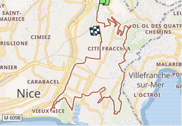
7.9 km | 10.3 km-effort
2h 13min
No
Trail Walking Nice - Collines niçoises - Photo
Walking
kenhava

Walking

Easy
(1)
Nice, Provence-Alpes-Côte d'Azur, Maritime Alps, France
21 km | 30 km-effort
6h 32min
No
Trail Walking Saint-Jean-Cap-Ferrat - Cap Ferrat 2011-10-27 - Photo
Walking
Cricounet84

Walking

Medium
(2)
Saint-Jean-Cap-Ferrat, Provence-Alpes-Côte d'Azur, Maritime Alps, France
10.9 km | 14 km-effort
4h 0min
Yes
Trail Walking Cantaron - Cantaron : Monts Macaron et Ubac  par Levens Tourette réelle - Photo
Walking
GUIDE
jouans

Walking

Very difficult
Cantaron, Provence-Alpes-Côte d'Azur, Maritime Alps, France
19.7 km | 35 km-effort
7h 57min
Yes
Trail Walking Saint-Jean-Cap-Ferrat - Tour du Cap Ferrat - Photo
Walking
GUIDE
Orcal37

Walking

Easy
Saint-Jean-Cap-Ferrat, Provence-Alpes-Côte d'Azur, Maritime Alps, France
7.1 km | 9.4 km-effort
1h 40min
Yes
Trail Walking Saint-Jean-Cap-Ferrat - w-frankrijk-tour-du-cap-ferrat - Photo
Walking
gpstracks

Walking

Very easy
(1)
Saint-Jean-Cap-Ferrat, Provence-Alpes-Côte d'Azur, Maritime Alps, France
6.5 km | 8.6 km-effort
Unknown
No
Trail Walking Èze - eze 221213 - Photo
Walking
legios84

Walking

Medium
(1)
Èze, Provence-Alpes-Côte d'Azur, Maritime Alps, France
9.9 km | 14.7 km-effort
2h 4min
Yes
Trail Walking Saint-Jean-Cap-Ferrat - Tour du Cap Ferrat - Photo
Walking
tracegps

Walking

Medium
(4)
Saint-Jean-Cap-Ferrat, Provence-Alpes-Côte d'Azur, Maritime Alps, France
8.9 km | 11.2 km-effort
2h 0min
Yes
Trail Walking Nice - Nice  cathédrale Russe  - Photo
Walking
JEANJOSY

Walking

Very easy
Nice, Provence-Alpes-Côte d'Azur, Maritime Alps, France
6.9 km | 7.8 km-effort
2h 10min
Yes


Close
My subscriptions