![](/images/other/stat-length.png)
![Trail Walking Aachen - Aix-la-Chapelle - Photo](https://media.geolcdn.com/t/1900/400/ext.pjpeg?maxdim=2&url=https%3A%2F%2Fstatic1.geolcdn.com%2Fsiteimages%2Fupload%2Ffiles%2F1553511878bg_sport_marche.png)
Aix-la-Chapelle
Greg813
User
![Length](/images/other/stat-length.png)
Length
12.9 km
![Max alt](https://static1.geolcdn.com/siteimages/upload/files/1508320355ic_sort_altitude_max_24dp.png)
Max alt
352 m
![Uphill gradient](https://static1.geolcdn.com/siteimages/upload/files/1508320355ic_sort_den_pos_24dp.png)
Uphill gradient
220 m
![Km-Effort](/images/other/stat-length.png)
Km-Effort
15.8 km
![Min alt](https://static1.geolcdn.com/siteimages/upload/files/1508320355ic_sort_altitude_min_24dp.png)
Min alt
176 m
![Downhill gradient](https://static1.geolcdn.com/siteimages/upload/files/1508320355ic_sort_den_neg_24dp.png)
Downhill gradient
221 m
![Boucle](https://static1.geolcdn.com/siteimages/upload/files/16400158638029165_repeat_loop_refresh_sync_direction_icon.png)
Boucle
Yes
Creation date :
2021-12-12 08:29:45.974
Updated on :
2021-12-18 18:09:14.131
![Walking](https://static1.geolcdn.com/sitytour/trail-icons/101.png)
2h54
Difficulty : Medium
![Scan this QR Code to open this trail in the SityTrail application](https://capi.geolives.com/qq0zvz2zws4bq2lad0pu/sitytour/trails/3024434/qr.png?size=200)
FREE GPS app for hiking
About
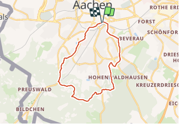
Trail Walking of 12.9 km to be discovered at North Rhine-Westphalia, Städteregion Aachen, Aachen. This trail is proposed by Greg813.
Description
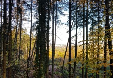
Randonnée avec Mettons le Monde en Marche dans les bois au sud d'Aix-la-Chapelle (Aachen) depuis la gare.
Pour d'autres photos, voir le site de l'association :
https://mmm-rando.org/aachen-allemagne-2021/
Positioning
Country:
Germany
Region :
North Rhine-Westphalia
Department/Province :
Städteregion Aachen
Municipality :
Aachen
Location:
Aachen-Mitte
Start:(Dec)
Start:(UTM)
294893 ; 5628087 (32U) N.
Comments
Trails nearby
![Trail Walking Aachen - Aix-la-Chapelle - Photo](https://media.geolcdn.com/t/375/260/ext.jpg?maxdim=2&url=https%3A%2F%2Fmedia.geolcdn.com%2Ff%2F19678e47-68ef-4997-bad3-67eb75fafd82.jpg)
![Walking Walking](https://static1.geolcdn.com/sitytour/trail-icons/101.png)
Aix-la-Chapelle
Walking
Easy
(1)
Aachen,
North Rhine-Westphalia,
Städteregion Aachen,
Germany
![](/images/other/stat-length.png)
11.4 km | 15.4 km-effort
3h 30min
![](https://static1.geolcdn.com/siteimages/upload/files/16400158638029165_repeat_loop_refresh_sync_direction_icon.png)
Yes
![Trail Walking Aachen - Aix-la-Chapelle - Photo](https://media.geolcdn.com/t/375/260/ext.jpg?maxdim=2&url=https%3A%2F%2Fmedia.geolcdn.com%2Ff%2Fefbe95f3-eeed-42aa-9acc-74aad4d18b78.jpg)
![Walking Walking](https://static1.geolcdn.com/sitytour/trail-icons/101.png)
Aix-la-Chapelle
Walking
Easy
(1)
Aachen,
North Rhine-Westphalia,
Städteregion Aachen,
Germany
![](/images/other/stat-length.png)
11.1 km | 13.4 km-effort
3h 2min
![](https://static1.geolcdn.com/siteimages/upload/files/16400158638029165_repeat_loop_refresh_sync_direction_icon.png)
Yes
![Trail Walking Kelmis - 20200730 - Les 3 Bornes 7.3 Km - Photo](https://media.geolcdn.com/t/375/260/ext.jpg?maxdim=2&url=https%3A%2F%2Fmedia.geolcdn.com%2Ff%2Fab7b3f98-4235-4a73-ba70-1bedd5c785f3.jpg)
![Walking Walking](https://static1.geolcdn.com/sitytour/trail-icons/101.png)
20200730 - Les 3 Bornes 7.3 Km
Walking
Difficult
(1)
Kelmis,
Wallonia,
Liège,
Belgium
![](/images/other/stat-length.png)
7.4 km | 10.4 km-effort
1h 50min
![](https://static1.geolcdn.com/siteimages/upload/files/16400158638029165_repeat_loop_refresh_sync_direction_icon.png)
Yes
![Trail Walking Kelmis - Venn Trilogie (1er étape) - Photo](https://media.geolcdn.com/t/375/260/ext.jpg?maxdim=2&url=https%3A%2F%2Fmedia.geolcdn.com%2Ff%2F1309a595-2e15-4d31-9259-ac0f30e3e1c8.jpg)
![Walking Walking](https://static1.geolcdn.com/sitytour/trail-icons/101.png)
Venn Trilogie (1er étape)
Walking
Medium
(1)
Kelmis,
Wallonia,
Liège,
Belgium
![](/images/other/stat-length.png)
25 km | 30 km-effort
5h 0min
![](https://static1.geolcdn.com/siteimages/upload/files/16400158638029165_repeat_loop_refresh_sync_direction_icon.png)
No
![Trail Walking Kelmis - Trois,Bornes - Vaals - Photo](https://media.geolcdn.com/t/375/260/ext.jpg?maxdim=2&url=https%3A%2F%2Fmedia.geolcdn.com%2Ff%2F57a9e4b2-2b91-4dde-a9e1-ded719735ee4.jpg)
![Walking Walking](https://static1.geolcdn.com/sitytour/trail-icons/101.png)
Trois,Bornes - Vaals
Walking
Medium
Kelmis,
Wallonia,
Liège,
Belgium
![](/images/other/stat-length.png)
12.4 km | 16.1 km-effort
3h 9min
![](https://static1.geolcdn.com/siteimages/upload/files/16400158638029165_repeat_loop_refresh_sync_direction_icon.png)
Yes
![Trail Walking Aachen - Aix-la-Chapelle (Rando & marché de Noël 🎅🎄) - Photo](https://media.geolcdn.com/t/375/260/ext.jpg?maxdim=2&url=https%3A%2F%2Fmedia.geolcdn.com%2Ff%2F4f83fd45-4a5a-463b-9f7a-8dd164ffae41.jpg)
![Walking Walking](https://static1.geolcdn.com/sitytour/trail-icons/101.png)
Aix-la-Chapelle (Rando & marché de Noël 🎅🎄)
Walking
Easy
(1)
Aachen,
North Rhine-Westphalia,
Städteregion Aachen,
Germany
![](/images/other/stat-length.png)
10.7 km | 13.2 km-effort
3h 0min
![](https://static1.geolcdn.com/siteimages/upload/files/16400158638029165_repeat_loop_refresh_sync_direction_icon.png)
Yes
![Trail On foot Aachen - Rundweg um Eilendorf - Photo](https://media.geolcdn.com/t/375/260/ext.jpg?maxdim=2&url=https%3A%2F%2Fmedia.geolcdn.com%2Ff%2F87580b8e-9a60-47cb-a755-acb46765e988.jpeg)
![On foot On foot](https://static1.geolcdn.com/sitytour/trail-icons/100.png)
Rundweg um Eilendorf
On foot
Easy
Aachen,
North Rhine-Westphalia,
Städteregion Aachen,
Germany
![](/images/other/stat-length.png)
12.6 km | 14.4 km-effort
3h 16min
![](https://static1.geolcdn.com/siteimages/upload/files/16400158638029165_repeat_loop_refresh_sync_direction_icon.png)
Yes
![Trail On foot Aachen - GrenzRouten: Verbindungsweg Aachen Hbf - Köpfchen - Photo](https://media.geolcdn.com/t/375/260/ext.jpg?maxdim=2&url=https%3A%2F%2Fmedia.geolcdn.com%2Ff%2Facb48f4b-f569-4f30-8283-8fbcc1250f19.jpeg)
![On foot On foot](https://static1.geolcdn.com/sitytour/trail-icons/100.png)
GrenzRouten: Verbindungsweg Aachen Hbf - Köpfchen
On foot
Easy
Aachen,
North Rhine-Westphalia,
Städteregion Aachen,
Germany
![](/images/other/stat-length.png)
4.1 km | 5 km-effort
1h 8min
![](https://static1.geolcdn.com/siteimages/upload/files/16400158638029165_repeat_loop_refresh_sync_direction_icon.png)
No
![Trail On foot Aachen - GrenzRouten: Verbindungsweg Aachen Hbf - Entenpfuhl - Photo](https://media.geolcdn.com/t/375/260/ext.jpg?maxdim=2&url=https%3A%2F%2Fmedia.geolcdn.com%2Ff%2Fda571a0a-0248-4360-bc28-1eb500fedad0.jpeg)
![On foot On foot](https://static1.geolcdn.com/sitytour/trail-icons/100.png)
GrenzRouten: Verbindungsweg Aachen Hbf - Entenpfuhl
On foot
Easy
Aachen,
North Rhine-Westphalia,
Städteregion Aachen,
Germany
![](/images/other/stat-length.png)
5.1 km | 6.7 km-effort
1h 31min
![](https://static1.geolcdn.com/siteimages/upload/files/16400158638029165_repeat_loop_refresh_sync_direction_icon.png)
No