![](/images/other/stat-length.png)
![Trail On foot Maincy - sur-les-pas-de-paul-c-zanne - Photo](https://media.geolcdn.com/t/1900/400/ext.pjpeg?maxdim=2&url=https%3A%2F%2Fstatic1.geolcdn.com%2Fsiteimages%2Fupload%2Ffiles%2F1545311037marcheuse_200dpi.jpg)
sur-les-pas-de-paul-c-zanne
Les 1000 pattes
Club randonnées SERVON
![Length](/images/other/stat-length.png)
Length
6 km
![Max alt](https://static1.geolcdn.com/siteimages/upload/files/1508320355ic_sort_altitude_max_24dp.png)
Max alt
81 m
![Uphill gradient](https://static1.geolcdn.com/siteimages/upload/files/1508320355ic_sort_den_pos_24dp.png)
Uphill gradient
89 m
![Km-Effort](/images/other/stat-length.png)
Km-Effort
7.2 km
![Min alt](https://static1.geolcdn.com/siteimages/upload/files/1508320355ic_sort_altitude_min_24dp.png)
Min alt
43 m
![Downhill gradient](https://static1.geolcdn.com/siteimages/upload/files/1508320355ic_sort_den_neg_24dp.png)
Downhill gradient
89 m
![Boucle](https://static1.geolcdn.com/siteimages/upload/files/16400158638029165_repeat_loop_refresh_sync_direction_icon.png)
Boucle
Yes
Creation date :
2021-12-11 13:48:36.454
Updated on :
2024-11-27 08:40:04.153
![On foot](https://static1.geolcdn.com/sitytour/trail-icons/100.png)
1h38
Difficulty : Very easy
![Scan this QR Code to open this trail in the SityTrail application](https://capi.geolives.com/qq0zvz2zws4bq2lad0pu/sitytour/trails/3023693/qr.png?size=200)
FREE GPS app for hiking
About
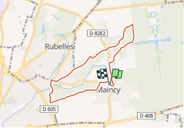
Trail On foot of 6 km to be discovered at Ile-de-France, Seine-et-Marne, Maincy. This trail is proposed by Les 1000 pattes.
Description
Parking Place de l'Eglise D82E2 à Maincy
Trajet Servon-->Maincy (24km: 21mn)
Positioning
Country:
France
Region :
Ile-de-France
Department/Province :
Seine-et-Marne
Municipality :
Maincy
Location:
Unknown
Start:(Dec)
Start:(UTM)
477816 ; 5377518 (31U) N.
Comments
Trails nearby
![Trail Mountain bike Melun - melun-bas.samois - Photo](https://media.geolcdn.com/t/375/260/ext.jpg?maxdim=2&url=https%3A%2F%2Fservices.sitytrail.com%2FGeolivesWS%2FDownloadMedia.ashx%3FTrailID%3D201635%26Media%3D20130630104925.jpeg)
![Mountain bike Mountain bike](https://static1.geolcdn.com/sitytour/trail-icons/202.png)
melun-bas.samois
Mountain bike
Medium
(1)
Melun,
Ile-de-France,
Seine-et-Marne,
France
![](/images/other/stat-length.png)
38 km | 43 km-effort
2h 45min
![](https://static1.geolcdn.com/siteimages/upload/files/16400158638029165_repeat_loop_refresh_sync_direction_icon.png)
Yes
![Trail Walking Melun - Le tour du Grand Paris via le gr1 : Etape 13 Melun Barbizon - Photo](https://media.geolcdn.com/t/375/260/43fa91c6-5130-4300-b61c-33f1d532d9df.jpg&format=jpg&maxdim=2)
![Walking Walking](https://static1.geolcdn.com/sitytour/trail-icons/101.png)
Le tour du Grand Paris via le gr1 : Etape 13 Melun Barbizon
Walking
Easy
Melun,
Ile-de-France,
Seine-et-Marne,
France
![](/images/other/stat-length.png)
27 km | 33 km-effort
5h 55min
![](https://static1.geolcdn.com/siteimages/upload/files/16400158638029165_repeat_loop_refresh_sync_direction_icon.png)
No
![Trail Walking Maincy - vaux le pénil - blandy les tours - Photo](https://media.geolcdn.com/t/375/260/5344f78f-37de-4136-b4f8-4ce06f4e96e0.jpg&format=jpg&maxdim=2)
![Walking Walking](https://static1.geolcdn.com/sitytour/trail-icons/101.png)
vaux le pénil - blandy les tours
Walking
Very easy
Maincy,
Ile-de-France,
Seine-et-Marne,
France
![](/images/other/stat-length.png)
21 km | 24 km-effort
5h 44min
![](https://static1.geolcdn.com/siteimages/upload/files/16400158638029165_repeat_loop_refresh_sync_direction_icon.png)
Yes
![Trail Walking Melun - Melun -- charrettes - Photo](https://media.geolcdn.com/t/375/260/ext.jpg?maxdim=2&url=https%3A%2F%2Fservices.sitytrail.com%2FGeolivesWS%2FDownloadMedia.ashx%3FTrailID%3D201785%26Media%3D20130630163457.jpg)
![Walking Walking](https://static1.geolcdn.com/sitytour/trail-icons/101.png)
Melun -- charrettes
Walking
Very easy
Melun,
Ile-de-France,
Seine-et-Marne,
France
![](/images/other/stat-length.png)
14.7 km | 16.5 km-effort
3h 48min
![](https://static1.geolcdn.com/siteimages/upload/files/16400158638029165_repeat_loop_refresh_sync_direction_icon.png)
No
![Trail Walking Le Mée-sur-Seine - Melun 01 - Photo](https://media.geolcdn.com/t/375/260/ext.jpg?maxdim=2&url=https%3A%2F%2Fservices.sitytrail.com%2FGeolivesWS%2FDownloadMedia.ashx%3FTrailID%3D183579%26Media%3D20130407182853.jpg)
![Walking Walking](https://static1.geolcdn.com/sitytour/trail-icons/101.png)
Melun 01
Walking
Very easy
Le Mée-sur-Seine,
Ile-de-France,
Seine-et-Marne,
France
![](/images/other/stat-length.png)
8 km | 9.1 km-effort
4h 26min
![](https://static1.geolcdn.com/siteimages/upload/files/16400158638029165_repeat_loop_refresh_sync_direction_icon.png)
No
![Trail Cycle Melun - melun bas samois 2011-10-30 12h04m11 - Photo](https://media.geolcdn.com/t/375/260/ext.jpg?maxdim=2&url=https%3A%2F%2Fstatic1.geolcdn.com%2Fsiteimages%2Fupload%2Ffiles%2F1524743154velo.jpg)
![Cycle Cycle](https://static1.geolcdn.com/sitytour/trail-icons/200.png)
melun bas samois 2011-10-30 12h04m11
Cycle
Medium
(1)
Melun,
Ile-de-France,
Seine-et-Marne,
France
![](/images/other/stat-length.png)
39 km | 44 km-effort
Unknown
![](https://static1.geolcdn.com/siteimages/upload/files/16400158638029165_repeat_loop_refresh_sync_direction_icon.png)
Yes
![Trail Walking Maincy - 3 chateaux - Photo](https://media.geolcdn.com/t/375/260/292423c5-20b3-4ed0-abe4-a1a9ed13f5c8.jpg&format=jpg&maxdim=2)
![Walking Walking](https://static1.geolcdn.com/sitytour/trail-icons/101.png)
3 chateaux
Walking
Medium
Maincy,
Ile-de-France,
Seine-et-Marne,
France
![](/images/other/stat-length.png)
26 km | 29 km-effort
6h 32min
![](https://static1.geolcdn.com/siteimages/upload/files/16400158638029165_repeat_loop_refresh_sync_direction_icon.png)
No
![Trail Walking Melun - blandy - Photo](https://media.geolcdn.com/t/375/260/5fa1f321-d94f-4615-aead-b2be579680ca.jpg&format=jpg&maxdim=2)
![Walking Walking](https://static1.geolcdn.com/sitytour/trail-icons/101.png)
blandy
Walking
Difficult
Melun,
Ile-de-France,
Seine-et-Marne,
France
![](/images/other/stat-length.png)
14 km | 16.2 km-effort
3h 9min
![](https://static1.geolcdn.com/siteimages/upload/files/16400158638029165_repeat_loop_refresh_sync_direction_icon.png)
No
![Trail Nordic walking La Rochette - La Rochette - Photo](https://media.geolcdn.com/t/375/260/ef85e396-0265-4837-a4b2-ed69b7259b6d.jpg&format=jpg&maxdim=2)
![Nordic walking Nordic walking](https://static1.geolcdn.com/sitytour/trail-icons/102.png)
La Rochette
Nordic walking
La Rochette,
Ile-de-France,
Seine-et-Marne,
France
![](/images/other/stat-length.png)
9.1 km | 10 km-effort
1h 42min
![](https://static1.geolcdn.com/siteimages/upload/files/16400158638029165_repeat_loop_refresh_sync_direction_icon.png)
Yes