![](/images/other/stat-length.png)
![Trail Walking Plougrescant - Penvénan: autour de Buguélès - Photo](https://media.geolcdn.com/t/1900/400/ext.pjpeg?maxdim=2&url=https%3A%2F%2Fstatic1.geolcdn.com%2Fsiteimages%2Fupload%2Ffiles%2F1553511878bg_sport_marche.png)
Penvénan: autour de Buguélès
Vasseur Jean Marc
User
![Length](/images/other/stat-length.png)
Length
17.8 km
![Max alt](https://static1.geolcdn.com/siteimages/upload/files/1508320355ic_sort_altitude_max_24dp.png)
Max alt
69 m
![Uphill gradient](https://static1.geolcdn.com/siteimages/upload/files/1508320355ic_sort_den_pos_24dp.png)
Uphill gradient
253 m
![Km-Effort](/images/other/stat-length.png)
Km-Effort
21 km
![Min alt](https://static1.geolcdn.com/siteimages/upload/files/1508320355ic_sort_altitude_min_24dp.png)
Min alt
-2 m
![Downhill gradient](https://static1.geolcdn.com/siteimages/upload/files/1508320355ic_sort_den_neg_24dp.png)
Downhill gradient
253 m
![Boucle](https://static1.geolcdn.com/siteimages/upload/files/16400158638029165_repeat_loop_refresh_sync_direction_icon.png)
Boucle
Yes
Creation date :
2021-11-25 14:09:47.862
Updated on :
2021-11-25 14:15:25.723
![Walking](https://static1.geolcdn.com/sitytour/trail-icons/101.png)
4h49
Difficulty : Very difficult
![Scan this QR Code to open this trail in the SityTrail application](https://capi.geolives.com/qq0zvz2zws4bq2lad0pu/sitytour/trails/3012294/qr.png?size=200)
FREE GPS app for hiking
About
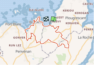
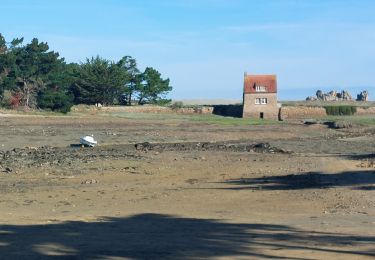
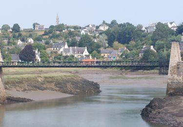
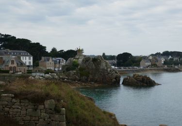
Trail Walking of 17.8 km to be discovered at Brittany, Côtes-d'Armor, Plougrescant. This trail is proposed by Vasseur Jean Marc.
Description
De nombreuses possibilités de raccourcir ou allonger le parcours.
Possibilité de déjeuner à l'Auberge Penn Ar Feunteun lors d'une rando resto
Positioning
Country:
France
Region :
Brittany
Department/Province :
Côtes-d'Armor
Municipality :
Plougrescant
Location:
Unknown
Start:(Dec)
Start:(UTM)
480745 ; 5409157 (30U) N.
Comments
Trails nearby
![Trail Walking Penvénan - Penvénan Port Blanc - GR34 Nantouar - 26.7km 305m 6h (1h) - 2024 07 05 - Photo](https://media.geolcdn.com/t/375/260/bda985c5-8238-4996-9606-a096b85b3cb7.jpg&format=jpg&maxdim=2)
![Walking Walking](https://static1.geolcdn.com/sitytour/trail-icons/101.png)
Penvénan Port Blanc - GR34 Nantouar - 26.7km 305m 6h (1h) - 2024 07 05
Walking
Medium
Penvénan,
Brittany,
Côtes-d'Armor,
France
![](/images/other/stat-length.png)
27 km | 31 km-effort
6h 0min
![](https://static1.geolcdn.com/siteimages/upload/files/16400158638029165_repeat_loop_refresh_sync_direction_icon.png)
Yes
![Trail Walking Plougrescant - Plougrescant - GR34 la Roche Jaune - 22.9km 260m 5h10 (45mn) - 2024 06 23 - Photo](https://media.geolcdn.com/t/375/260/2359623e-5d45-4bf5-bcc2-f64fe8f92be9.jpg&format=jpg&maxdim=2)
![Walking Walking](https://static1.geolcdn.com/sitytour/trail-icons/101.png)
Plougrescant - GR34 la Roche Jaune - 22.9km 260m 5h10 (45mn) - 2024 06 23
Walking
Medium
Plougrescant,
Brittany,
Côtes-d'Armor,
France
![](/images/other/stat-length.png)
23 km | 26 km-effort
5h 10min
![](https://static1.geolcdn.com/siteimages/upload/files/16400158638029165_repeat_loop_refresh_sync_direction_icon.png)
Yes
![Trail Walking Penvénan - Buguélès Penvénan - GR34 Raluzet Placen Amic - 11.4km 160m 2h50 - 2023 09 15 - Photo](https://media.geolcdn.com/t/375/260/e4423474-b66f-4ea0-a231-fcf6eb14eb9f.jpg&format=jpg&maxdim=2)
![Walking Walking](https://static1.geolcdn.com/sitytour/trail-icons/101.png)
Buguélès Penvénan - GR34 Raluzet Placen Amic - 11.4km 160m 2h50 - 2023 09 15
Walking
Difficult
Penvénan,
Brittany,
Côtes-d'Armor,
France
![](/images/other/stat-length.png)
11.4 km | 13.6 km-effort
2h 50min
![](https://static1.geolcdn.com/siteimages/upload/files/16400158638029165_repeat_loop_refresh_sync_direction_icon.png)
Yes
![Trail Walking Plouguiel - GR_34_DF_27_Plouguiel_Plougrescant_20240913 - Photo](https://media.geolcdn.com/t/375/260/fb8a8607-68ab-4cf3-ba53-1723f0cb9310.jpg&format=jpg&maxdim=2)
![Walking Walking](https://static1.geolcdn.com/sitytour/trail-icons/101.png)
GR_34_DF_27_Plouguiel_Plougrescant_20240913
Walking
Easy
Plouguiel,
Brittany,
Côtes-d'Armor,
France
![](/images/other/stat-length.png)
17.5 km | 20 km-effort
4h 32min
![](https://static1.geolcdn.com/siteimages/upload/files/16400158638029165_repeat_loop_refresh_sync_direction_icon.png)
No
![Trail Walking Plougrescant - GR_34_DG_28_Plougrescant_Perros-Guirec_20240914 - Photo](https://media.geolcdn.com/t/375/260/e7f4cfc0-8327-4a35-8f91-6c420e8362fb.jpg&format=jpg&maxdim=2)
![Walking Walking](https://static1.geolcdn.com/sitytour/trail-icons/101.png)
GR_34_DG_28_Plougrescant_Perros-Guirec_20240914
Walking
Easy
Plougrescant,
Brittany,
Côtes-d'Armor,
France
![](/images/other/stat-length.png)
22 km | 26 km-effort
5h 10min
![](https://static1.geolcdn.com/siteimages/upload/files/16400158638029165_repeat_loop_refresh_sync_direction_icon.png)
No
![Trail Walking Kerbors - GR_34_DE_26_Kerbors_Plouguiel_20240819 - Photo](https://media.geolcdn.com/t/375/260/1c285370-a1d7-439a-878c-cb48dfe91862.jpg&format=jpg&maxdim=2)
![Walking Walking](https://static1.geolcdn.com/sitytour/trail-icons/101.png)
GR_34_DE_26_Kerbors_Plouguiel_20240819
Walking
Easy
Kerbors,
Brittany,
Côtes-d'Armor,
France
![](/images/other/stat-length.png)
15.2 km | 18.1 km-effort
3h 23min
![](https://static1.geolcdn.com/siteimages/upload/files/16400158638029165_repeat_loop_refresh_sync_direction_icon.png)
No
![Trail Walking Plougrescant - Plougrescant - Photo](https://media.geolcdn.com/t/375/260/2a9570bf-93d0-4b8a-a51c-944d451c40d8.jpg&format=jpg&maxdim=2)
![Walking Walking](https://static1.geolcdn.com/sitytour/trail-icons/101.png)
Plougrescant
Walking
Difficult
Plougrescant,
Brittany,
Côtes-d'Armor,
France
![](/images/other/stat-length.png)
13.8 km | 15.5 km-effort
4h 53min
![](https://static1.geolcdn.com/siteimages/upload/files/16400158638029165_repeat_loop_refresh_sync_direction_icon.png)
Yes
![Trail Walking Plougrescant - Plougrescant 10,3km - Photo](https://media.geolcdn.com/t/375/260/fb977883-8846-4363-88ce-e4ce215b4973.jpg&format=jpg&maxdim=2)
![Walking Walking](https://static1.geolcdn.com/sitytour/trail-icons/101.png)
Plougrescant 10,3km
Walking
Medium
Plougrescant,
Brittany,
Côtes-d'Armor,
France
![](/images/other/stat-length.png)
10.3 km | 11.6 km-effort
2h 45min
![](https://static1.geolcdn.com/siteimages/upload/files/16400158638029165_repeat_loop_refresh_sync_direction_icon.png)
Yes
![Electric bike Electric bike](https://static1.geolcdn.com/sitytour/trail-icons/205.png)
Port Blanc et Bugélès à partir de Treguier
Electric bike
Medium
Plouguiel,
Brittany,
Côtes-d'Armor,
France
![](/images/other/stat-length.png)
25 km | 29 km-effort
3h 3min
![](https://static1.geolcdn.com/siteimages/upload/files/16400158638029165_repeat_loop_refresh_sync_direction_icon.png)
Yes