![](/images/other/stat-length.png)
![Trail Walking Tréminis - La Casse du Ferrand - Photo](https://media.geolcdn.com/t/1900/400/ext.pjpeg?maxdim=2&url=https%3A%2F%2Fstatic1.geolcdn.com%2Fsiteimages%2Fupload%2Ffiles%2F1553511878bg_sport_marche.png)
La Casse du Ferrand
rapako
User
![Length](/images/other/stat-length.png)
Length
8.9 km
![Max alt](https://static1.geolcdn.com/siteimages/upload/files/1508320355ic_sort_altitude_max_24dp.png)
Max alt
1701 m
![Uphill gradient](https://static1.geolcdn.com/siteimages/upload/files/1508320355ic_sort_den_pos_24dp.png)
Uphill gradient
740 m
![Km-Effort](/images/other/stat-length.png)
Km-Effort
18.8 km
![Min alt](https://static1.geolcdn.com/siteimages/upload/files/1508320355ic_sort_altitude_min_24dp.png)
Min alt
981 m
![Downhill gradient](https://static1.geolcdn.com/siteimages/upload/files/1508320355ic_sort_den_neg_24dp.png)
Downhill gradient
747 m
![Boucle](https://static1.geolcdn.com/siteimages/upload/files/16400158638029165_repeat_loop_refresh_sync_direction_icon.png)
Boucle
Yes
Creation date :
2021-11-23 09:07:25.0
Updated on :
2021-11-23 17:02:47.842
![Walking](https://static1.geolcdn.com/sitytour/trail-icons/101.png)
5h33
Difficulty : Medium
![Scan this QR Code to open this trail in the SityTrail application](https://capi.geolives.com/qq0zvz2zws4bq2lad0pu/sitytour/trails/3010714/qr.png?size=200)
FREE GPS app for hiking
About
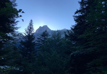
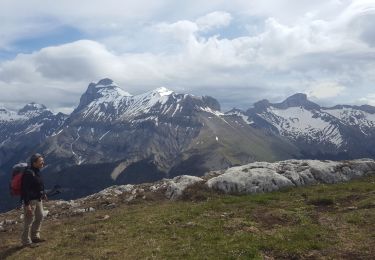
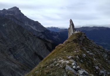
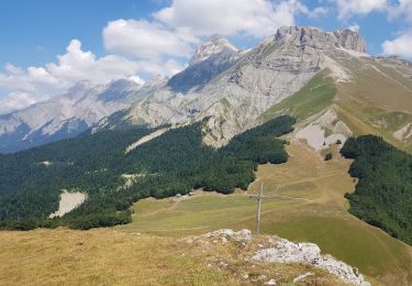
Trail Walking of 8.9 km to be discovered at Auvergne-Rhône-Alpes, Isère, Tréminis. This trail is proposed by rapako.
Description
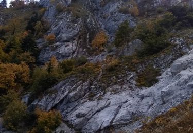
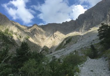
Effectuée fin novembre. Les pierres étaient gelées et très glissantes, pas raisonnable de monter jusqu'à la Fétoure.
Le passage délicat avant le Ruisseau sous la Roche pour revenir en boucle sur le Sud, n'était également pas praticable à cause du gel et son etroitesse.
Positioning
Country:
France
Region :
Auvergne-Rhône-Alpes
Department/Province :
Isère
Municipality :
Tréminis
Location:
Unknown
Start:(Dec)
Start:(UTM)
720180 ; 4958064 (31T) N.
Comments
Trails nearby
![Trail Walking Tréminis - Boucle et sommet de l'Aup - Photo](https://media.geolcdn.com/t/375/260/b4bb8fed-3a0e-46fc-b5a1-1acfca2c36af.jpg&format=jpg&maxdim=2)
![Walking Walking](https://static1.geolcdn.com/sitytour/trail-icons/101.png)
Boucle et sommet de l'Aup
Walking
Very difficult
Tréminis,
Auvergne-Rhône-Alpes,
Isère,
France
![](/images/other/stat-length.png)
13.6 km | 24 km-effort
7h 5min
![](https://static1.geolcdn.com/siteimages/upload/files/16400158638029165_repeat_loop_refresh_sync_direction_icon.png)
Yes
![Trail Walking Tréminis - Le col de La Croix - Photo](https://media.geolcdn.com/t/375/260/e5d94408-dab6-4b8f-bedb-4be5204f8582.jpg&format=jpg&maxdim=2)
![Walking Walking](https://static1.geolcdn.com/sitytour/trail-icons/101.png)
Le col de La Croix
Walking
Difficult
Tréminis,
Auvergne-Rhône-Alpes,
Isère,
France
![](/images/other/stat-length.png)
8.8 km | 16.5 km-effort
3h 31min
![](https://static1.geolcdn.com/siteimages/upload/files/16400158638029165_repeat_loop_refresh_sync_direction_icon.png)
Yes
![Trail Walking Tréminis - Treminis : Montagne de Paille, col de la Croix. - Photo](https://media.geolcdn.com/t/375/260/7c502d8c-1592-4cbb-8a0b-789b09d1751b.jpg&format=jpg&maxdim=2)
![Walking Walking](https://static1.geolcdn.com/sitytour/trail-icons/101.png)
Treminis : Montagne de Paille, col de la Croix.
Walking
Medium
Tréminis,
Auvergne-Rhône-Alpes,
Isère,
France
![](/images/other/stat-length.png)
11 km | 21 km-effort
5h 29min
![](https://static1.geolcdn.com/siteimages/upload/files/16400158638029165_repeat_loop_refresh_sync_direction_icon.png)
Yes
![Trail Electric bike Saint-Baudille-et-Pipet - Sainte Baudille de Pipet - St Pancrasse - Photo](https://media.geolcdn.com/t/375/260/98775b0d-8be1-4414-b804-8cc2ea33e09e.jpg&format=jpg&maxdim=2)
![Electric bike Electric bike](https://static1.geolcdn.com/sitytour/trail-icons/205.png)
Sainte Baudille de Pipet - St Pancrasse
Electric bike
Easy
Saint-Baudille-et-Pipet,
Auvergne-Rhône-Alpes,
Isère,
France
![](/images/other/stat-length.png)
34 km | 46 km-effort
3h 36min
![](https://static1.geolcdn.com/siteimages/upload/files/16400158638029165_repeat_loop_refresh_sync_direction_icon.png)
Yes
![Trail Walking Tréminis - Courtier, les arçons, Rochasac - Photo](https://media.geolcdn.com/t/375/260/5bb9e707-c81b-496a-b529-22d1df699d9c.jpg&format=jpg&maxdim=2)
![Walking Walking](https://static1.geolcdn.com/sitytour/trail-icons/101.png)
Courtier, les arçons, Rochasac
Walking
Difficult
Tréminis,
Auvergne-Rhône-Alpes,
Isère,
France
![](/images/other/stat-length.png)
16.3 km | 33 km-effort
6h 54min
![](https://static1.geolcdn.com/siteimages/upload/files/16400158638029165_repeat_loop_refresh_sync_direction_icon.png)
Yes
![Trail Walking Tréminis - Château des chèvres et tentative du pré de l'Aupet - Photo](https://media.geolcdn.com/t/375/260/18b0e7f4-3621-4641-9652-c3abd580bfbd.jpg&format=jpg&maxdim=2)
![Walking Walking](https://static1.geolcdn.com/sitytour/trail-icons/101.png)
Château des chèvres et tentative du pré de l'Aupet
Walking
Medium
Tréminis,
Auvergne-Rhône-Alpes,
Isère,
France
![](/images/other/stat-length.png)
10.6 km | 24 km-effort
5h 19min
![](https://static1.geolcdn.com/siteimages/upload/files/16400158638029165_repeat_loop_refresh_sync_direction_icon.png)
Yes
![Trail Walking Tréminis - La Pointe Feuillette par le sentier Amigoni et le Col de La Croix - Photo](https://media.geolcdn.com/t/375/260/ext.jpg?maxdim=2&url=https%3A%2F%2Fservices.sitytrail.com%2FGeolivesWS%2FDownloadMedia.ashx%3FTrailID%3D1015115%26Media%3Dfix__20180802144101.jpg)
![Walking Walking](https://static1.geolcdn.com/sitytour/trail-icons/101.png)
La Pointe Feuillette par le sentier Amigoni et le Col de La Croix
Walking
Medium
Tréminis,
Auvergne-Rhône-Alpes,
Isère,
France
![](/images/other/stat-length.png)
13.3 km | 25 km-effort
5h 4min
![](https://static1.geolcdn.com/siteimages/upload/files/16400158638029165_repeat_loop_refresh_sync_direction_icon.png)
Yes
![Trail Walking Lus-la-Croix-Haute - col de jajenne - Photo](https://media.geolcdn.com/t/375/260/ext.jpg?maxdim=2&url=https%3A%2F%2Fservices.sitytrail.com%2FGeolivesWS%2FDownloadMedia.ashx%3FTrailID%3D815719%26Media%3Dfix__20170823113559.jpg)
![Walking Walking](https://static1.geolcdn.com/sitytour/trail-icons/101.png)
col de jajenne
Walking
Very easy
Lus-la-Croix-Haute,
Auvergne-Rhône-Alpes,
Drôme,
France
![](/images/other/stat-length.png)
6 km | 11.2 km-effort
4h 30min
![](https://static1.geolcdn.com/siteimages/upload/files/16400158638029165_repeat_loop_refresh_sync_direction_icon.png)
Yes
![Trail Walking Tréminis - CHATEAU des CHÈVRES-27-08-2016 - Photo](https://media.geolcdn.com/t/375/260/ext.jpg?maxdim=2&url=https%3A%2F%2Fservices.sitytrail.com%2FGeolivesWS%2FDownloadMedia.ashx%3FTrailID%3D626139%26Media%3D20160827132334.jpg)
![Walking Walking](https://static1.geolcdn.com/sitytour/trail-icons/101.png)
CHATEAU des CHÈVRES-27-08-2016
Walking
Very difficult
Tréminis,
Auvergne-Rhône-Alpes,
Isère,
France
![](/images/other/stat-length.png)
16.2 km | 28 km-effort
7h 2min
![](https://static1.geolcdn.com/siteimages/upload/files/16400158638029165_repeat_loop_refresh_sync_direction_icon.png)
No