![](/images/other/stat-length.png)
![Trail Walking Baratier - val Ubaye- Baratier village - Photo](https://media.geolcdn.com/t/1900/400/ext.pjpeg?maxdim=2&url=https%3A%2F%2Fstatic1.geolcdn.com%2Fsiteimages%2Fupload%2Ffiles%2F1553511878bg_sport_marche.png)
val Ubaye- Baratier village
damlou
User
![Length](/images/other/stat-length.png)
Length
5.3 km
![Max alt](https://static1.geolcdn.com/siteimages/upload/files/1508320355ic_sort_altitude_max_24dp.png)
Max alt
1020 m
![Uphill gradient](https://static1.geolcdn.com/siteimages/upload/files/1508320355ic_sort_den_pos_24dp.png)
Uphill gradient
193 m
![Km-Effort](/images/other/stat-length.png)
Km-Effort
7.9 km
![Min alt](https://static1.geolcdn.com/siteimages/upload/files/1508320355ic_sort_altitude_min_24dp.png)
Min alt
851 m
![Downhill gradient](https://static1.geolcdn.com/siteimages/upload/files/1508320355ic_sort_den_neg_24dp.png)
Downhill gradient
196 m
![Boucle](https://static1.geolcdn.com/siteimages/upload/files/16400158638029165_repeat_loop_refresh_sync_direction_icon.png)
Boucle
Yes
Creation date :
2021-11-21 11:09:08.059
Updated on :
2021-11-21 12:58:13.692
![Walking](https://static1.geolcdn.com/sitytour/trail-icons/101.png)
1h29
Difficulty : Medium
![Scan this QR Code to open this trail in the SityTrail application](https://capi.geolives.com/qq0zvz2zws4bq2lad0pu/sitytour/trails/3008818/qr.png?size=200)
FREE GPS app for hiking
About
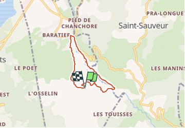
Trail Walking of 5.3 km to be discovered at Provence-Alpes-Côte d'Azur, Hautes-Alpes, Baratier. This trail is proposed by damlou.
Description
Aller idem grande boucle à la maison rose tout droit vers place village facile
Retour le long du vachère attention par temps de pluie
Chemin vallonné
Positioning
Country:
France
Region :
Provence-Alpes-Côte d'Azur
Department/Province :
Hautes-Alpes
Municipality :
Baratier
Location:
Unknown
Start:(Dec)
Start:(UTM)
301396 ; 4933341 (32T) N.
Comments
Trails nearby
![Trail Walking Les Orres - lac de Sainte Marguerite Les Orres - Photo](https://media.geolcdn.com/t/375/260/ext.jpg?maxdim=2&url=https%3A%2F%2Fservices.sitytrail.com%2FGeolivesWS%2FDownloadMedia.ashx%3FTrailID%3D1018436%26Media%3Dfix__20180808142719.jpg)
![Walking Walking](https://static1.geolcdn.com/sitytour/trail-icons/101.png)
lac de Sainte Marguerite Les Orres
Walking
Medium
(2)
Les Orres,
Provence-Alpes-Côte d'Azur,
Hautes-Alpes,
France
![](/images/other/stat-length.png)
11.1 km | 19 km-effort
4h 25min
![](https://static1.geolcdn.com/siteimages/upload/files/16400158638029165_repeat_loop_refresh_sync_direction_icon.png)
Yes
![Trail Walking Saint-Sauveur - 2012-08-07 Méale - Photo](https://media.geolcdn.com/t/375/260/ext.jpg?maxdim=2&url=https%3A%2F%2Fservices.sitytrail.com%2FGeolivesWS%2FDownloadMedia.ashx%3FTrailID%3D145125%26Media%3D8f8ba6a5-bed5-4779-b0c7-5d5fa06c0aa0.jpeg)
![Walking Walking](https://static1.geolcdn.com/sitytour/trail-icons/101.png)
2012-08-07 Méale
Walking
Difficult
(1)
Saint-Sauveur,
Provence-Alpes-Côte d'Azur,
Hautes-Alpes,
France
![](/images/other/stat-length.png)
8.3 km | 14.9 km-effort
3h 34min
![](https://static1.geolcdn.com/siteimages/upload/files/16400158638029165_repeat_loop_refresh_sync_direction_icon.png)
Yes
![Trail Mountain bike Les Orres - Les Orres 1800 - Savines le Lac - Photo](https://media.geolcdn.com/t/375/260/ext.jpg?maxdim=2&url=https%3A%2F%2Fservices.sitytrail.com%2FGeolivesWS%2FDownloadMedia.ashx%3FTrailID%3D105450%26Media%3D9182_3.jpg)
![Mountain bike Mountain bike](https://static1.geolcdn.com/sitytour/trail-icons/202.png)
Les Orres 1800 - Savines le Lac
Mountain bike
Difficult
(1)
Les Orres,
Provence-Alpes-Côte d'Azur,
Hautes-Alpes,
France
![](/images/other/stat-length.png)
28 km | 42 km-effort
3h 0min
![](https://static1.geolcdn.com/siteimages/upload/files/16400158638029165_repeat_loop_refresh_sync_direction_icon.png)
No
![Trail Walking Les Orres - l'Aupillon - Photo](https://media.geolcdn.com/t/375/260/38306995-9c71-4e70-80a5-d8bb94d45592.jpg&format=jpg&maxdim=2)
![Walking Walking](https://static1.geolcdn.com/sitytour/trail-icons/101.png)
l'Aupillon
Walking
Difficult
Les Orres,
Provence-Alpes-Côte d'Azur,
Hautes-Alpes,
France
![](/images/other/stat-length.png)
16.8 km | 33 km-effort
7h 43min
![](https://static1.geolcdn.com/siteimages/upload/files/16400158638029165_repeat_loop_refresh_sync_direction_icon.png)
Yes
![Trail Walking Les Orres - le Pouzenc - Photo](https://media.geolcdn.com/t/375/260/efe95a97-87aa-4d7d-b7d6-f810bef16b2e.jpg&format=jpg&maxdim=2)
![Walking Walking](https://static1.geolcdn.com/sitytour/trail-icons/101.png)
le Pouzenc
Walking
Difficult
Les Orres,
Provence-Alpes-Côte d'Azur,
Hautes-Alpes,
France
![](/images/other/stat-length.png)
14.6 km | 31 km-effort
7h 41min
![](https://static1.geolcdn.com/siteimages/upload/files/16400158638029165_repeat_loop_refresh_sync_direction_icon.png)
Yes
![Trail Walking Crots - Morgon par la fontaine de l'Ours - Photo](https://media.geolcdn.com/t/375/260/e020d87b-3349-4509-bff9-6b59601d138c.jpg&format=jpg&maxdim=2)
![Walking Walking](https://static1.geolcdn.com/sitytour/trail-icons/101.png)
Morgon par la fontaine de l'Ours
Walking
Medium
Crots,
Provence-Alpes-Côte d'Azur,
Hautes-Alpes,
France
![](/images/other/stat-length.png)
17.7 km | 33 km-effort
6h 26min
![](https://static1.geolcdn.com/siteimages/upload/files/16400158638029165_repeat_loop_refresh_sync_direction_icon.png)
Yes
![Trail Walking Crots - LES CROTS Boscodon ,Fontaine de l Ours ,sentier des Pyramides cirque du Morgon o m - Photo](https://media.geolcdn.com/t/375/260/94dbf83e-b1dc-42f7-b3af-31980f7aee36.jpg&format=jpg&maxdim=2)
![Walking Walking](https://static1.geolcdn.com/sitytour/trail-icons/101.png)
LES CROTS Boscodon ,Fontaine de l Ours ,sentier des Pyramides cirque d...
Walking
Difficult
Crots,
Provence-Alpes-Côte d'Azur,
Hautes-Alpes,
France
![](/images/other/stat-length.png)
12.6 km | 22 km-effort
4h 10min
![](https://static1.geolcdn.com/siteimages/upload/files/16400158638029165_repeat_loop_refresh_sync_direction_icon.png)
Yes
![Trail Walking Les Orres - les orres 1800 . lac sainte marguerite / montée par le sentier et retour par la piste - Photo](https://media.geolcdn.com/t/375/260/827a9108-7754-443f-a277-3e00c67d44c5.jpg&format=jpg&maxdim=2)
![Walking Walking](https://static1.geolcdn.com/sitytour/trail-icons/101.png)
les orres 1800 . lac sainte marguerite / montée par le sentier et retour par ...
Walking
Easy
Les Orres,
Provence-Alpes-Côte d'Azur,
Hautes-Alpes,
France
![](/images/other/stat-length.png)
10.2 km | 18.2 km-effort
3h 59min
![](https://static1.geolcdn.com/siteimages/upload/files/16400158638029165_repeat_loop_refresh_sync_direction_icon.png)
Yes
![Trail Walking Embrun - Embrun - 3.4km 90m 1h00 - 2018 06 26 - privé - Photo](https://media.geolcdn.com/t/375/260/ext.jpg?maxdim=2&url=https%3A%2F%2Fservices.sitytrail.com%2FGeolivesWS%2FDownloadMedia.ashx%3FTrailID%3D999315%26Media%3Dfix__20180626102346.jpg)
![Walking Walking](https://static1.geolcdn.com/sitytour/trail-icons/101.png)
Embrun - 3.4km 90m 1h00 - 2018 06 26 - privé
Walking
Very easy
Embrun,
Provence-Alpes-Côte d'Azur,
Hautes-Alpes,
France
![](/images/other/stat-length.png)
3.1 km | 4.1 km-effort
1h 15min
![](https://static1.geolcdn.com/siteimages/upload/files/16400158638029165_repeat_loop_refresh_sync_direction_icon.png)
Yes