![](/images/other/stat-length.png)
![Trail Walking Outremécourt - cité de la Mothe, Soulaucourt - Photo](https://media.geolcdn.com/t/1900/400/ext.pjpeg?maxdim=2&url=https%3A%2F%2Fstatic1.geolcdn.com%2Fsiteimages%2Fupload%2Ffiles%2F1553511878bg_sport_marche.png)
cité de la Mothe, Soulaucourt
jeannine grandjean
User
![Length](/images/other/stat-length.png)
Length
3.3 km
![Max alt](https://static1.geolcdn.com/siteimages/upload/files/1508320355ic_sort_altitude_max_24dp.png)
Max alt
503 m
![Uphill gradient](https://static1.geolcdn.com/siteimages/upload/files/1508320355ic_sort_den_pos_24dp.png)
Uphill gradient
72 m
![Km-Effort](/images/other/stat-length.png)
Km-Effort
4.2 km
![Min alt](https://static1.geolcdn.com/siteimages/upload/files/1508320355ic_sort_altitude_min_24dp.png)
Min alt
460 m
![Downhill gradient](https://static1.geolcdn.com/siteimages/upload/files/1508320355ic_sort_den_neg_24dp.png)
Downhill gradient
75 m
![Boucle](https://static1.geolcdn.com/siteimages/upload/files/16400158638029165_repeat_loop_refresh_sync_direction_icon.png)
Boucle
Yes
Creation date :
2021-11-21 09:57:53.643
Updated on :
2021-11-23 07:27:23.944
![Walking](https://static1.geolcdn.com/sitytour/trail-icons/101.png)
1h22
Difficulty : Easy
![Scan this QR Code to open this trail in the SityTrail application](https://capi.geolives.com/qq0zvz2zws4bq2lad0pu/sitytour/trails/3008702/qr.png?size=200)
FREE GPS app for hiking
About
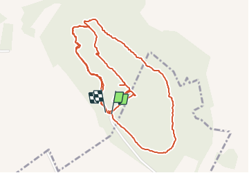
Trail Walking of 3.3 km to be discovered at Grand Est, Haute-Marne, Outremécourt. This trail is proposed by jeannine grandjean.
Description
itinéraire à travers l'ancienne cité avec de bons vestiges et de nombreuses informations
2 parcours proposés
l'itinéraire (rouge) qui fait le tour de la cité est en partie non entretenue
Positioning
Country:
France
Region :
Grand Est
Department/Province :
Haute-Marne
Municipality :
Outremécourt
Location:
Unknown
Start:(Dec)
Start:(UTM)
699377 ; 5343207 (31U) N.
Comments
Trails nearby
![Trail Walking Graffigny-Chemin - entre Graffigny et Chemin - Photo](https://media.geolcdn.com/t/375/260/ext.jpg?maxdim=2&url=https%3A%2F%2Fstatic1.geolcdn.com%2Fsiteimages%2Fupload%2Ffiles%2F1553511878bg_sport_marche.png)
![Walking Walking](https://static1.geolcdn.com/sitytour/trail-icons/101.png)
entre Graffigny et Chemin
Walking
Medium
Graffigny-Chemin,
Grand Est,
Haute-Marne,
France
![](/images/other/stat-length.png)
5.8 km | 8.1 km-effort
1h 50min
![](https://static1.geolcdn.com/siteimages/upload/files/16400158638029165_repeat_loop_refresh_sync_direction_icon.png)
Yes