


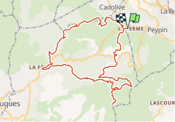

13.3 km | 20 km-effort


User


FREE GPS app for hiking
 SityTrail
IGN / Geographical institutes
SityTrail World
The world is yours!
Trail Mountain bike of 27 km to be discovered at Provence-Alpes-Côte d'Azur, Bouches-du-Rhône, Peypin. This trail is proposed by duchaine.nicolas.
Départ au Relais des Termes - montée sur des grands chemins un peu caillouteux vers le Ratier puis le Mont St Julien _ descente vers Plan de Cuques, pas mal technique sur la fin puis remontée par de beaux chemins DFCI vers


Walking
Walking

Walking

Walking
Walking

On foot
Walking

Mountain bike

Walking