![](/images/other/stat-length.png)
![Trail Walking Lisle - Rando de lisle - Photo](https://media.geolcdn.com/t/1900/400/ext.pjpeg?maxdim=2&url=https%3A%2F%2Fstatic1.geolcdn.com%2Fsiteimages%2Fupload%2Ffiles%2F1553511878bg_sport_marche.png)
Rando de lisle
Jean LABADIE
User
![Length](/images/other/stat-length.png)
Length
18.7 km
![Max alt](https://static1.geolcdn.com/siteimages/upload/files/1508320355ic_sort_altitude_max_24dp.png)
Max alt
149 m
![Uphill gradient](https://static1.geolcdn.com/siteimages/upload/files/1508320355ic_sort_den_pos_24dp.png)
Uphill gradient
212 m
![Km-Effort](/images/other/stat-length.png)
Km-Effort
21 km
![Min alt](https://static1.geolcdn.com/siteimages/upload/files/1508320355ic_sort_altitude_min_24dp.png)
Min alt
86 m
![Downhill gradient](https://static1.geolcdn.com/siteimages/upload/files/1508320355ic_sort_den_neg_24dp.png)
Downhill gradient
216 m
![Boucle](https://static1.geolcdn.com/siteimages/upload/files/16400158638029165_repeat_loop_refresh_sync_direction_icon.png)
Boucle
Yes
Creation date :
2021-11-19 14:47:20.433
Updated on :
2022-01-27 13:16:34.348
![Walking](https://static1.geolcdn.com/sitytour/trail-icons/101.png)
4h21
Difficulty : Medium
![Scan this QR Code to open this trail in the SityTrail application](https://capi.geolives.com/qq0zvz2zws4bq2lad0pu/sitytour/trails/3007035/qr.png?size=200)
FREE GPS app for hiking
About
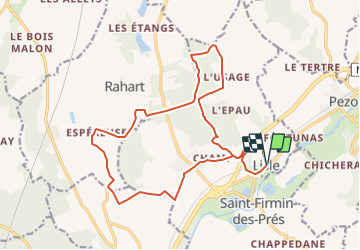
Trail Walking of 18.7 km to be discovered at Centre-Loire Valley, Loir-et-Cher, Lisle. This trail is proposed by Jean LABADIE.
Description
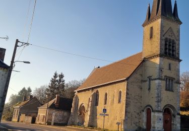
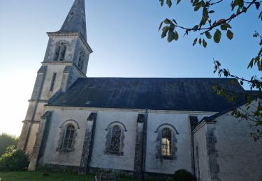
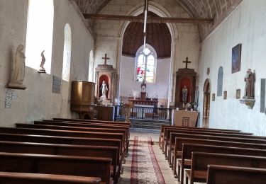
Le départ de la randonnée se fait depuis le parking en face de l'église.
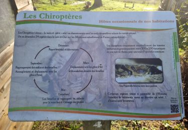
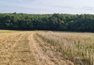
La randonnée traverse les bois de l'Epau qui sont privés. Veillez à bien suivre le tracé qui emprunte des chemins communaux. Attention en période de chasse. Battues fréquentes.
Positioning
Country:
France
Region :
Centre-Loire Valley
Department/Province :
Loir-et-Cher
Municipality :
Lisle
Location:
Unknown
Start:(Dec)
Start:(UTM)
359064 ; 5301604 (31T) N.
Comments
Trails nearby
![Trail Walking Lisle - Lisle - Bord du Loir - Photo](https://media.geolcdn.com/t/375/260/4f9116bd-eecc-48ec-adb9-fd3c5cad4087.jpg&format=jpg&maxdim=2)
![Walking Walking](https://static1.geolcdn.com/sitytour/trail-icons/101.png)
Lisle - Bord du Loir
Walking
Easy
Lisle,
Centre-Loire Valley,
Loir-et-Cher,
France
![](/images/other/stat-length.png)
8.9 km | 9.5 km-effort
2h 9min
![](https://static1.geolcdn.com/siteimages/upload/files/16400158638029165_repeat_loop_refresh_sync_direction_icon.png)
Yes
![Trail Walking Saint-Firmin-des-Prés - Saint-Firmin-des-Prés - Photo](https://media.geolcdn.com/t/375/260/a5813cc0-d151-48d6-b693-f67e132742f6.jpg&format=jpg&maxdim=2)
![Walking Walking](https://static1.geolcdn.com/sitytour/trail-icons/101.png)
Saint-Firmin-des-Prés
Walking
Easy
Saint-Firmin-des-Prés,
Centre-Loire Valley,
Loir-et-Cher,
France
![](/images/other/stat-length.png)
8.9 km | 9.9 km-effort
1h 58min
![](https://static1.geolcdn.com/siteimages/upload/files/16400158638029165_repeat_loop_refresh_sync_direction_icon.png)
Yes
![Trail Walking Rahart - Rahart - Photo](https://media.geolcdn.com/t/375/260/f650ba70-4d58-496b-8e3a-7549b98be635.jpg&format=jpg&maxdim=2)
![Walking Walking](https://static1.geolcdn.com/sitytour/trail-icons/101.png)
Rahart
Walking
Easy
Rahart,
Centre-Loire Valley,
Loir-et-Cher,
France
![](/images/other/stat-length.png)
8.1 km | 9.3 km-effort
2h 6min
![](https://static1.geolcdn.com/siteimages/upload/files/16400158638029165_repeat_loop_refresh_sync_direction_icon.png)
Yes
![Trail Walking Lisle - Lisle - Bois de l'Epau - Photo](https://media.geolcdn.com/t/375/260/f2ea5793-eafb-48f8-8f49-2ef6ceea9d28.jpg&format=jpg&maxdim=2)
![Walking Walking](https://static1.geolcdn.com/sitytour/trail-icons/101.png)
Lisle - Bois de l'Epau
Walking
Easy
Lisle,
Centre-Loire Valley,
Loir-et-Cher,
France
![](/images/other/stat-length.png)
8.9 km | 10.2 km-effort
2h 19min
![](https://static1.geolcdn.com/siteimages/upload/files/16400158638029165_repeat_loop_refresh_sync_direction_icon.png)
Yes
![Trail Walking Renay - Renay - Champs Bois Chapelle Eglise - Photo](https://media.geolcdn.com/t/375/260/ddc8d202-9993-403c-b2f2-d3983276bdc7.jpg&format=jpg&maxdim=2)
![Walking Walking](https://static1.geolcdn.com/sitytour/trail-icons/101.png)
Renay - Champs Bois Chapelle Eglise
Walking
Medium
Renay,
Centre-Loire Valley,
Loir-et-Cher,
France
![](/images/other/stat-length.png)
13.8 km | 15.8 km-effort
3h 35min
![](https://static1.geolcdn.com/siteimages/upload/files/16400158638029165_repeat_loop_refresh_sync_direction_icon.png)
Yes
![Trail Walking Saint-Ouen - Parcours nature à Saint-Ouen (41100) - Photo](https://media.geolcdn.com/t/375/260/f3b5adb8-9482-4a86-92c2-c7e1d40e05c6.jpg&format=jpg&maxdim=2)
![Walking Walking](https://static1.geolcdn.com/sitytour/trail-icons/101.png)
Parcours nature à Saint-Ouen (41100)
Walking
Easy
Saint-Ouen,
Centre-Loire Valley,
Loir-et-Cher,
France
![](/images/other/stat-length.png)
16.1 km | 19 km-effort
4h 3min
![](https://static1.geolcdn.com/siteimages/upload/files/16400158638029165_repeat_loop_refresh_sync_direction_icon.png)
Yes
![Trail Walking Saint-Ouen - Saint-Ouen - Circuit découverte 2 - Photo](https://media.geolcdn.com/t/375/260/a63d411c-172f-46e6-aeb6-2fe4f4e2c8c3.jpg&format=jpg&maxdim=2)
![Walking Walking](https://static1.geolcdn.com/sitytour/trail-icons/101.png)
Saint-Ouen - Circuit découverte 2
Walking
Very easy
Saint-Ouen,
Centre-Loire Valley,
Loir-et-Cher,
France
![](/images/other/stat-length.png)
10.5 km | 12.4 km-effort
3h 16min
![](https://static1.geolcdn.com/siteimages/upload/files/16400158638029165_repeat_loop_refresh_sync_direction_icon.png)
Yes
![Trail Walking Saint-Firmin-des-Prés - St Firmin Mjo - Photo](https://media.geolcdn.com/t/375/260/ext.jpg?maxdim=2&url=https%3A%2F%2Fstatic1.geolcdn.com%2Fsiteimages%2Fupload%2Ffiles%2F1553511878bg_sport_marche.png)
![Walking Walking](https://static1.geolcdn.com/sitytour/trail-icons/101.png)
St Firmin Mjo
Walking
Easy
Saint-Firmin-des-Prés,
Centre-Loire Valley,
Loir-et-Cher,
France
![](/images/other/stat-length.png)
16 km | 17.9 km-effort
3h 9min
![](https://static1.geolcdn.com/siteimages/upload/files/16400158638029165_repeat_loop_refresh_sync_direction_icon.png)
Yes
![Trail Walking Busloup - Busloup - Photo](https://media.geolcdn.com/t/375/260/ext.jpg?maxdim=2&url=https%3A%2F%2Fstatic1.geolcdn.com%2Fsiteimages%2Fupload%2Ffiles%2F1553511878bg_sport_marche.png)
![Walking Walking](https://static1.geolcdn.com/sitytour/trail-icons/101.png)
Busloup
Walking
Easy
Busloup,
Centre-Loire Valley,
Loir-et-Cher,
France
![](/images/other/stat-length.png)
21 km | 25 km-effort
3h 8min
![](https://static1.geolcdn.com/siteimages/upload/files/16400158638029165_repeat_loop_refresh_sync_direction_icon.png)
Yes