![](/images/other/stat-length.png)
![Trail Walking Escragnolles - Escragnolles, megalithes de Mons, cascade Clar - Photo](https://media.geolcdn.com/t/1900/400/c046b9ca-00b0-4232-a7b9-f9120af0f0f0.jpg&format=pjpeg&maxdim=2)
Escragnolles, megalithes de Mons, cascade Clar
GrouGary
User
![Length](/images/other/stat-length.png)
![Max alt](https://static1.geolcdn.com/siteimages/upload/files/1508320355ic_sort_altitude_max_24dp.png)
![Uphill gradient](https://static1.geolcdn.com/siteimages/upload/files/1508320355ic_sort_den_pos_24dp.png)
![Km-Effort](/images/other/stat-length.png)
![Min alt](https://static1.geolcdn.com/siteimages/upload/files/1508320355ic_sort_altitude_min_24dp.png)
![Downhill gradient](https://static1.geolcdn.com/siteimages/upload/files/1508320355ic_sort_den_neg_24dp.png)
![Boucle](https://static1.geolcdn.com/siteimages/upload/files/16400158638029165_repeat_loop_refresh_sync_direction_icon.png)
![Walking](https://static1.geolcdn.com/sitytour/trail-icons/101.png)
3h02
Difficulty : Easy
![Scan this QR Code to open this trail in the SityTrail application](https://capi.geolives.com/qq0zvz2zws4bq2lad0pu/sitytour/trails/3006905/qr.png?size=200)
FREE GPS app for hiking
About
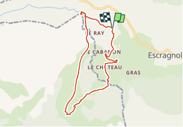
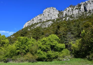
Trail Walking of 9 km to be discovered at Provence-Alpes-Côte d'Azur, Maritime Alps, Escragnolles. This trail is proposed by GrouGary.
Description
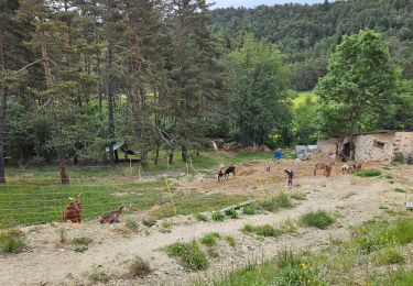
Boucle tranquille dans un paysage rural (moutons,chevaux), entre les villages d'Escragnolles et de Mons.
Nombreux dolmens assez bien conservés, un peu en dehors des sentiers balisés mais facilement repérables.
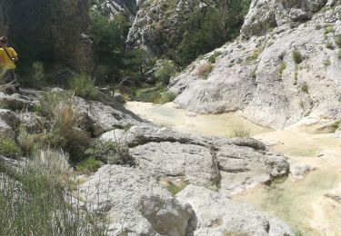
Une cascade magique qui semble sortie d'une résurgence rocheuse.
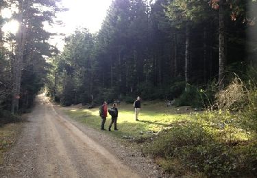
Positioning
Comments
Trails nearby
![Trail Walking Mons - tour du Mt Lachens - Photo](https://media.geolcdn.com/t/375/260/ext.jpg?maxdim=2&url=https%3A%2F%2Fservices.sitytrail.com%2FGeolivesWS%2FDownloadMedia.ashx%3FTrailID%3D167544%26Media%3D20121228095006.jpg)
![Walking Walking](https://static1.geolcdn.com/sitytour/trail-icons/101.png)
Walking
![](/images/other/stat-length.png)
![](https://static1.geolcdn.com/siteimages/upload/files/16400158638029165_repeat_loop_refresh_sync_direction_icon.png)
![Trail Walking Escragnolles - Casade du Ray (Clars) depuis les Gallants - Photo](https://media.geolcdn.com/t/375/260/a42f38d6-7773-4eff-b635-6c5634fe1592.jpg&format=jpg&maxdim=2)
![Walking Walking](https://static1.geolcdn.com/sitytour/trail-icons/101.png)
Walking
![](/images/other/stat-length.png)
![](https://static1.geolcdn.com/siteimages/upload/files/16400158638029165_repeat_loop_refresh_sync_direction_icon.png)
![Trail Walking Saint-Vallier-de-Thiey - Arche de Ponadieu Source de la Pare Baou Mourine Vieux Pont - Photo](https://media.geolcdn.com/t/375/260/7bf7c645-d759-4e3b-9f63-302e7218f005.jpg&format=jpg&maxdim=2)
![Walking Walking](https://static1.geolcdn.com/sitytour/trail-icons/101.png)
Walking
![](/images/other/stat-length.png)
![](https://static1.geolcdn.com/siteimages/upload/files/16400158638029165_repeat_loop_refresh_sync_direction_icon.png)
![Trail Walking Saint-Vallier-de-Thiey - St Vallier de Thiey - Aqueduc de Belletrud - Arche de Ponadieu - Photo](https://media.geolcdn.com/t/375/260/102f751b-e867-453b-847f-fc313f16fe9f.jpg&format=jpg&maxdim=2)
![Walking Walking](https://static1.geolcdn.com/sitytour/trail-icons/101.png)
Walking
![](/images/other/stat-length.png)
![](https://static1.geolcdn.com/siteimages/upload/files/16400158638029165_repeat_loop_refresh_sync_direction_icon.png)
![Trail Walking Escragnolles - escragnolles mourine - Photo](https://media.geolcdn.com/t/375/260/6cf5f747-cefb-423b-ae55-31ddf95937fc.jpg&format=jpg&maxdim=2)
![Walking Walking](https://static1.geolcdn.com/sitytour/trail-icons/101.png)
Walking
![](/images/other/stat-length.png)
![](https://static1.geolcdn.com/siteimages/upload/files/16400158638029165_repeat_loop_refresh_sync_direction_icon.png)
![Trail On foot Caille - Grand tour du haut Estéron - Etape 5 - Photo](https://media.geolcdn.com/t/375/260/e0be63bf-1b07-4796-9aef-aaad8742cfa1.jpeg&format=jpg&maxdim=2)
![On foot On foot](https://static1.geolcdn.com/sitytour/trail-icons/100.png)
On foot
![](/images/other/stat-length.png)
![](https://static1.geolcdn.com/siteimages/upload/files/16400158638029165_repeat_loop_refresh_sync_direction_icon.png)
![Trail On foot Escragnolles - Plateau de Briasq - Photo](https://media.geolcdn.com/t/375/260/3318d519-9f3b-4858-a9ae-b470b623f859.jpeg&format=jpg&maxdim=2)
![On foot On foot](https://static1.geolcdn.com/sitytour/trail-icons/100.png)
On foot
![](/images/other/stat-length.png)
![](https://static1.geolcdn.com/siteimages/upload/files/16400158638029165_repeat_loop_refresh_sync_direction_icon.png)
![Trail Walking Andon - L'Audibergue du Pont du Loup - Photo](https://media.geolcdn.com/t/375/260/461a541c-f76c-4a15-9b4e-2811bf184191.jpg&format=jpg&maxdim=2)
![Walking Walking](https://static1.geolcdn.com/sitytour/trail-icons/101.png)
Walking
![](/images/other/stat-length.png)
![](https://static1.geolcdn.com/siteimages/upload/files/16400158638029165_repeat_loop_refresh_sync_direction_icon.png)
![Walking Walking](https://static1.geolcdn.com/sitytour/trail-icons/101.png)
Walking
![](/images/other/stat-length.png)
![](https://static1.geolcdn.com/siteimages/upload/files/16400158638029165_repeat_loop_refresh_sync_direction_icon.png)