Trail Mountain bike Castellane - vtt-de-castellane-au-lac-de-castillon - Photo
 pascalou73
pascalou73

User GUIDE

© OpenStreetMap contributors
Length
Length
14.7 km
Max alt
Max alt
903 m
Uphill gradient
Uphill gradient
362 m
Km-Effort
Km-Effort  
19.5 km
Min alt
Min alt
713 m
Downhill gradient
Downhill gradient
363 m
Boucle
Boucle
Yes
Creation date :
2021-11-17 11:53:30.652
Updated on :
2021-11-17 11:56:02.068

(0 Reviews)

Mountain bike
Mountain bike
--
Difficulty : Unknown

Scan this QR Code to open this trail in the SityTrail application

FREE GPS app for hiking

Logo SityTrail SityTrail

IGN / Geographical institutes

Download SityTrail from the App Store Download SityTrail from Google Play

Logo SityTrail SityTrail World

The world is yours!

Download SityTrail from the App Store Download SityTrail from Google Play Download SityTrail on Huawei AppGallery

About

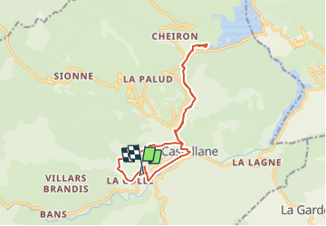
Trail Mountain bike of 14.7 km to be discovered at Provence-Alpes-Côte d'Azur, Alpes-de-Haute-Provence, Castellane. This trail is proposed by pascalou73.

Description

Voilà une randonnée VTT sur le village de Castellane une sortie VTT qui combine 3 circuits de l'office du tourisme . une randonnée avec de beaux passages et de belle cote .à découvrir

Elevation profile

Photos

Positioning

Country:
France
Region :
Provence-Alpes-Côte d'Azur
Department/Province :
Alpes-de-Haute-Provence
Municipality :
Castellane
Location:
Unknown
Start:(UTM)
298588 ; 4857087 (32T) N.

Trails nearby

Trail Walking Castellane - Sentier des Siréniens  - Photo
Walking
Dervalmarc

Walking

Very easy
(1)
Castellane, Provence-Alpes-Côte d'Azur, Alpes-de-Haute-Provence, France
3.8 km | 5.5 km-effort
1h 9min
Yes
Trail Walking Castellane - cadiere de brandis - Photo
Walking
choux83

Walking

Very easy
(1)
Castellane, Provence-Alpes-Côte d'Azur, Alpes-de-Haute-Provence, France
8.9 km | 14.6 km-effort
2h 27min
No
Trail Walking Castellane - Cadières  de Brandis version Light - Photo
Walking
GUIDE
donda

Walking

Difficult
Castellane, Provence-Alpes-Côte d'Azur, Alpes-de-Haute-Provence, France
9.2 km | 15.4 km-effort
3h 0min
Yes
Trail Walking Castellane - Cadières de Brandis - Photo
Walking
jmheydorff

Walking

Medium
(1)
Castellane, Provence-Alpes-Côte d'Azur, Alpes-de-Haute-Provence, France
10.7 km | 18.4 km-effort
3h 51min
Yes
Trail Walking Castellane - la colle cadieres de brandis 20kms 1086m - Photo
Walking
GUIDE
Danielba

Walking

Medium
(1)
Castellane, Provence-Alpes-Côte d'Azur, Alpes-de-Haute-Provence, France
19.6 km | 33 km-effort
7h 44min
Yes
Trail Walking Castellane - castellane - Photo
Walking
RoMo

Walking

Medium
Castellane, Provence-Alpes-Côte d'Azur, Alpes-de-Haute-Provence, France
4.7 km | 8 km-effort
1h 26min
Yes
Trail Walking Castellane - La Colle : Cadières de Brandis - Photo
Walking
ETMU5496

Walking

Difficult
Castellane, Provence-Alpes-Côte d'Azur, Alpes-de-Haute-Provence, France
17.5 km | 30 km-effort
6h 54min
Yes
Trail Walking Demandolx - Demandolx cremon 1000m 16kms  - Photo
Walking
GUIDE
Danielba

Walking

Very difficult
Demandolx, Provence-Alpes-Côte d'Azur, Alpes-de-Haute-Provence, France
14.8 km | 27 km-effort
8h 5min
Yes
Trail Walking Castellane - Thyrs : sommet du Robion - Photo
Walking
ETMU5496

Walking

Difficult
Castellane, Provence-Alpes-Côte d'Azur, Alpes-de-Haute-Provence, France
14.6 km | 28 km-effort
6h 16min
Yes


Close
My subscriptions