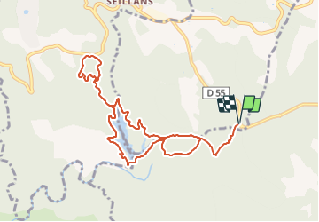
![](/images/other/stat-length.png)
![Trail Walking Fayence - tour du lac du Méaulx - Photo](https://media.geolcdn.com/t/1900/400/ext.pjpeg?maxdim=2&url=https%3A%2F%2Fstatic1.geolcdn.com%2Fsiteimages%2Fupload%2Ffiles%2F1553511878bg_sport_marche.png)
tour du lac du Méaulx
jwo47
User
![Length](/images/other/stat-length.png)
![Max alt](https://static1.geolcdn.com/siteimages/upload/files/1508320355ic_sort_altitude_max_24dp.png)
![Uphill gradient](https://static1.geolcdn.com/siteimages/upload/files/1508320355ic_sort_den_pos_24dp.png)
![Km-Effort](/images/other/stat-length.png)
![Min alt](https://static1.geolcdn.com/siteimages/upload/files/1508320355ic_sort_altitude_min_24dp.png)
![Downhill gradient](https://static1.geolcdn.com/siteimages/upload/files/1508320355ic_sort_den_neg_24dp.png)
![Boucle](https://static1.geolcdn.com/siteimages/upload/files/16400158638029165_repeat_loop_refresh_sync_direction_icon.png)
![Walking](https://static1.geolcdn.com/sitytour/trail-icons/101.png)
3h03
Difficulty : Difficult
![Scan this QR Code to open this trail in the SityTrail application](https://capi.geolives.com/qq0zvz2zws4bq2lad0pu/sitytour/trails/3004407/qr.png?size=200)
FREE GPS app for hiking
About
Trail Walking of 10.6 km to be discovered at Provence-Alpes-Côte d'Azur, Var, Fayence. This trail is proposed by jwo47.
Description
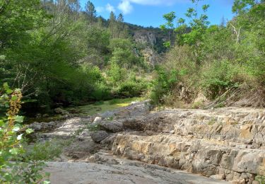
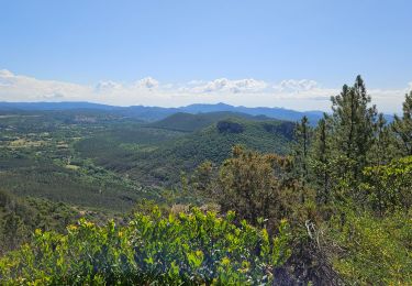
Rando facile et accessible à tous principalement sur piste avec un de 214m pour 11km. Le peu de dénivelé permet de faire ces 11km avec un picnic à la moitié du chemin sur les bords du lac. Les couleurs en octobre novembre sont très belles. Une petite difficulté tout de même avec le passage d'un gué. Donc à éviter le lendemain d'une journée pluvieuse.
Positioning
Comments
Trails nearby
![Trail Walking Bagnols-en-Forêt - La Colle du Rouet par le Castel Diaou - Le Muy - Photo](https://media.geolcdn.com/t/375/260/ext.jpg?maxdim=2&url=https%3A%2F%2Fservices.sitytrail.com%2FGeolivesWS%2FDownloadMedia.ashx%3FTrailID%3D191579%26Media%3D15205_3.jpg)
![Walking Walking](https://static1.geolcdn.com/sitytour/trail-icons/101.png)
Walking
![](/images/other/stat-length.png)
![](https://static1.geolcdn.com/siteimages/upload/files/16400158638029165_repeat_loop_refresh_sync_direction_icon.png)
![Trail On foot Bagnols-en-Forêt - BAGNOLS EN FORET- Bois du défens DRI - Photo](https://media.geolcdn.com/t/375/260/ext.jpg?maxdim=2&url=https%3A%2F%2Fstatic1.geolcdn.com%2Fsiteimages%2Fupload%2Ffiles%2F1545311037marcheuse_200dpi.jpg)
![On foot On foot](https://static1.geolcdn.com/sitytour/trail-icons/100.png)
On foot
![](/images/other/stat-length.png)
![](https://static1.geolcdn.com/siteimages/upload/files/16400158638029165_repeat_loop_refresh_sync_direction_icon.png)
![Trail Walking Bagnols-en-Forêt - Gorges du Blavet au col de la pierre du coucou - Photo](https://media.geolcdn.com/t/375/260/09e580ef-d921-4dee-80f6-a698afe27096.jpg&format=jpg&maxdim=2)
![Walking Walking](https://static1.geolcdn.com/sitytour/trail-icons/101.png)
Walking
![](/images/other/stat-length.png)
![](https://static1.geolcdn.com/siteimages/upload/files/16400158638029165_repeat_loop_refresh_sync_direction_icon.png)
![Trail sport Bagnols-en-Forêt - Lac Rioutard Bagnols en forêt - Photo](https://media.geolcdn.com/t/375/260/0154e3c4-4912-418f-af0f-e920b58b6bc0.jpg&format=jpg&maxdim=2)
sport
![](/images/other/stat-length.png)
![](https://static1.geolcdn.com/siteimages/upload/files/16400158638029165_repeat_loop_refresh_sync_direction_icon.png)
![Trail sport Bagnols-en-Forêt - Gorges de Blavet pays de Fayence - Photo](https://media.geolcdn.com/t/375/260/752b007a-5919-43b0-bdb0-68a447f575ab.jpg&format=jpg&maxdim=2)
sport
![](/images/other/stat-length.png)
![](https://static1.geolcdn.com/siteimages/upload/files/16400158638029165_repeat_loop_refresh_sync_direction_icon.png)
![Trail sport Bagnols-en-Forêt - Bagnols en Forêt les meules - Photo](https://media.geolcdn.com/t/375/260/4bb66a92-f34f-4592-9bb4-da4e654f5bf9.jpg&format=jpg&maxdim=2)
sport
![](/images/other/stat-length.png)
![](https://static1.geolcdn.com/siteimages/upload/files/16400158638029165_repeat_loop_refresh_sync_direction_icon.png)
![Trail Walking Bagnols-en-Forêt - Bagnols en Forêt, Pic de la Gardiette , Oppidum de La Forteresse - Photo](https://media.geolcdn.com/t/375/260/667ab0dc-5c64-4e1e-a401-74d35bc7da93.jpg&format=jpg&maxdim=2)
![Walking Walking](https://static1.geolcdn.com/sitytour/trail-icons/101.png)
Walking
![](/images/other/stat-length.png)
![](https://static1.geolcdn.com/siteimages/upload/files/16400158638029165_repeat_loop_refresh_sync_direction_icon.png)
![Trail Walking Seillans - Lac de Méaulx - Photo](https://media.geolcdn.com/t/375/260/b678c47e-c211-45af-8f95-9193a892a418.jpg&format=jpg&maxdim=2)
![Walking Walking](https://static1.geolcdn.com/sitytour/trail-icons/101.png)
Walking
![](/images/other/stat-length.png)
![](https://static1.geolcdn.com/siteimages/upload/files/16400158638029165_repeat_loop_refresh_sync_direction_icon.png)
![Trail Walking Bagnols-en-Forêt - Gorges du Blavet - Photo](https://media.geolcdn.com/t/375/260/f64ac804-86fa-483d-a3a0-c10a6b29b92b.jpg&format=jpg&maxdim=2)
![Walking Walking](https://static1.geolcdn.com/sitytour/trail-icons/101.png)
Walking
![](/images/other/stat-length.png)
![](https://static1.geolcdn.com/siteimages/upload/files/16400158638029165_repeat_loop_refresh_sync_direction_icon.png)