Trail Walking La Bâtie-Rolland - La_Batie_Rolland_6km-5386049-1636999570-141 - Photo

La_Batie_Rolland_6km-5386049-1636999570-141

 thonyc
thonyc

User GUIDE

© OpenStreetMap contributors
Length
Length
6.4 km
Max alt
Max alt
193 m
Uphill gradient
Uphill gradient
96 m
Km-Effort
Km-Effort  
7.7 km
Min alt
Min alt
144 m
Downhill gradient
Downhill gradient
98 m
Boucle
Boucle
Yes
Creation date :
2021-11-16 08:14:29.622
Updated on :
2021-11-16 08:20:00.402

(0 Reviews)

Walking
Walking
2h00
Difficulty : Easy

Scan this QR Code to open this trail in the SityTrail application

FREE GPS app for hiking

Logo SityTrail SityTrail

IGN / Geographical institutes

Download SityTrail from the App Store Download SityTrail from Google Play

Logo SityTrail SityTrail World

The world is yours!

Download SityTrail from the App Store Download SityTrail from Google Play Download SityTrail on Huawei AppGallery

About

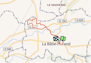
Trail Walking of 6.4 km to be discovered at Auvergne-Rhône-Alpes, Drôme, La Bâtie-Rolland. This trail is proposed by thonyc.

Elevation profile

Positioning

Country:
France
Region :
Auvergne-Rhône-Alpes
Department/Province :
Drôme
Municipality :
La Bâtie-Rolland
Location:
Unknown
Start:(UTM)
648204 ; 4935057 (31T) N.

Comments

Please log in to post a review or rate the element


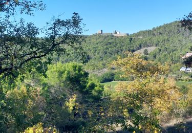
Sympa, variée. Un topo précis est disponible sur le site de Montélimar-aglo: circuit 104. Au départ, il serait dommage de ne pas monter jusqu'à la table d'orientation, 15mn AR.


Trails nearby

Trail Walking Portes-en-Valdaine - GPX-Rando-Plaine-Portoise-nouvelleversion - Photo
Walking
GUIDE
thonyc

Walking

Easy
(1)
Portes-en-Valdaine, Auvergne-Rhône-Alpes, Drôme, France
7.1 km | 8.2 km-effort
2h 0min
Yes
Trail Walking Portes-en-Valdaine - Portes-en-Valdaine Serre-de-Mirabel 11km. - Photo
Walking
chancha

Walking

Difficult
(1)
Portes-en-Valdaine, Auvergne-Rhône-Alpes, Drôme, France
10.8 km | 14.7 km-effort
3h 20min
Yes
Trail Mountain bike Puygiron - Puygiron VTT n°5 - Photo
Mountain bike
tracegps

Mountain bike

Very difficult
(1)
Puygiron, Auvergne-Rhône-Alpes, Drôme, France
47 km | 60 km-effort
3h 0min
Yes
Trail Walking La Touche - La Touche Crêtes de l'ysard 12km. - Photo
Walking
chancha

Walking

Difficult
(1)
La Touche, Auvergne-Rhône-Alpes, Drôme, France
12.1 km | 16.8 km-effort
3h 48min
Yes
Trail Walking Portes-en-Valdaine - 26 portes en valdaine - Photo
Walking
GUIDE
randodyssée

Walking

Very easy
Portes-en-Valdaine, Auvergne-Rhône-Alpes, Drôme, France
10.6 km | 14.5 km-effort
4h 10min
Yes
Trail Walking Puygiron - 26 Puygiron au coucher du soleil  - Photo
Walking
Maryma

Walking

Medium
Puygiron, Auvergne-Rhône-Alpes, Drôme, France
5.7 km | 8.1 km-effort
1h 50min
Yes
Trail Walking Montboucher-sur-Jabron - 20240428 Rando vieux  - Photo
Walking
Havani

Walking

Very easy
Montboucher-sur-Jabron, Auvergne-Rhône-Alpes, Drôme, France
6.1 km | 6.5 km-effort
5h 17min
Yes
Trail Walking Rochefort-en-Valdaine - tmpWriteApidae_267713_fr - Photo
Walking
GUIDE
thonyc

Walking

Easy
Rochefort-en-Valdaine, Auvergne-Rhône-Alpes, Drôme, France
7.3 km | 10.3 km-effort
2h 30min
Yes
Trail On foot Portes-en-Valdaine - Rando des 15 en courant #26 - Photo
On foot
Julie LABBE

On foot

Medium
(1)
Portes-en-Valdaine, Auvergne-Rhône-Alpes, Drôme, France
19.4 km | 27 km-effort
6h 9min
Yes


Close
My subscriptions