![](/images/other/stat-length.png)
![Trail Walking Saint-Jean-des-Vignes - Saint-Jean-des-Vignes - De Saint-Jean à Pierre Folle - Photo](https://media.geolcdn.com/t/1900/400/09c240b5-53a5-4d13-9478-c40ff2324f7d.jpg&format=pjpeg&maxdim=2)
Saint-Jean-des-Vignes - De Saint-Jean à Pierre Folle
Sigmut
User
![Length](/images/other/stat-length.png)
Length
3.3 km
![Max alt](https://static1.geolcdn.com/siteimages/upload/files/1508320355ic_sort_altitude_max_24dp.png)
Max alt
380 m
![Uphill gradient](https://static1.geolcdn.com/siteimages/upload/files/1508320355ic_sort_den_pos_24dp.png)
Uphill gradient
62 m
![Km-Effort](/images/other/stat-length.png)
Km-Effort
4.2 km
![Min alt](https://static1.geolcdn.com/siteimages/upload/files/1508320355ic_sort_altitude_min_24dp.png)
Min alt
332 m
![Downhill gradient](https://static1.geolcdn.com/siteimages/upload/files/1508320355ic_sort_den_neg_24dp.png)
Downhill gradient
62 m
![Boucle](https://static1.geolcdn.com/siteimages/upload/files/16400158638029165_repeat_loop_refresh_sync_direction_icon.png)
Boucle
Yes
Creation date :
2021-11-11 10:37:17.392
Updated on :
2023-01-21 22:40:20.564
![Walking](https://static1.geolcdn.com/sitytour/trail-icons/101.png)
1h19
Difficulty : Easy
![Scan this QR Code to open this trail in the SityTrail application](https://capi.geolives.com/qq0zvz2zws4bq2lad0pu/sitytour/trails/2999230/qr.png?size=200)
FREE GPS app for hiking
About
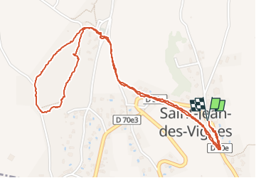
Trail Walking of 3.3 km to be discovered at Auvergne-Rhône-Alpes, Rhône, Saint-Jean-des-Vignes. This trail is proposed by Sigmut.
Description
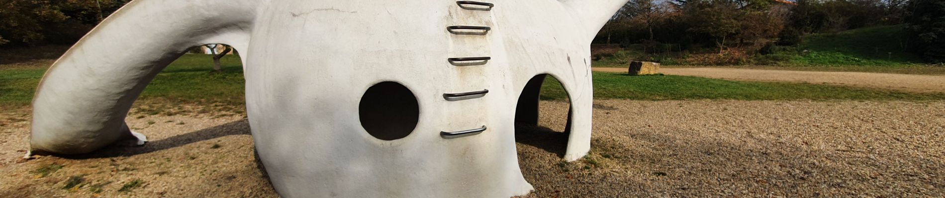
Petite Rando agréable avec des enfants
Positioning
Country:
France
Region :
Auvergne-Rhône-Alpes
Department/Province :
Rhône
Municipality :
Saint-Jean-des-Vignes
Location:
Unknown
Start:(Dec)
Start:(UTM)
630694 ; 5081545 (31T) N.
Comments
Trails nearby
![Trail Mountain bike Lozanne - La 5ème Vélozannaise (2014-VTT-45km) - Lozanne - Photo](https://media.geolcdn.com/t/375/260/ext.jpg?maxdim=2&url=https%3A%2F%2Fservices.sitytrail.com%2FGeolivesWS%2FDownloadMedia.ashx%3FTrailID%3D318042%26Media%3D17513_6.jpg)
![Mountain bike Mountain bike](https://static1.geolcdn.com/sitytour/trail-icons/202.png)
La 5ème Vélozannaise (2014-VTT-45km) - Lozanne
Mountain bike
Difficult
(1)
Lozanne,
Auvergne-Rhône-Alpes,
Rhône,
France
![](/images/other/stat-length.png)
45 km | 59 km-effort
3h 45min
![](https://static1.geolcdn.com/siteimages/upload/files/16400158638029165_repeat_loop_refresh_sync_direction_icon.png)
Yes
![Trail On foot Saint-Jean-des-Vignes - De Bagnols à Lozanne - Photo](https://media.geolcdn.com/t/375/260/0483cf43-fc67-45ae-bc2f-363ddcb48e98.jpeg&format=jpg&maxdim=2)
![On foot On foot](https://static1.geolcdn.com/sitytour/trail-icons/100.png)
De Bagnols à Lozanne
On foot
Easy
Saint-Jean-des-Vignes,
Auvergne-Rhône-Alpes,
Rhône,
France
![](/images/other/stat-length.png)
4 km | 5 km-effort
1h 7min
![](https://static1.geolcdn.com/siteimages/upload/files/16400158638029165_repeat_loop_refresh_sync_direction_icon.png)
No
![Trail On foot Lozanne - De Lozanne à Marcy - Photo](https://media.geolcdn.com/t/375/260/08fe2957-d9d7-452a-b8d4-1f5434bd4ed8.jpeg&format=jpg&maxdim=2)
![On foot On foot](https://static1.geolcdn.com/sitytour/trail-icons/100.png)
De Lozanne à Marcy
On foot
Easy
Lozanne,
Auvergne-Rhône-Alpes,
Rhône,
France
![](/images/other/stat-length.png)
12.2 km | 15.6 km-effort
3h 32min
![](https://static1.geolcdn.com/siteimages/upload/files/16400158638029165_repeat_loop_refresh_sync_direction_icon.png)
No
![Trail Nordic walking Bagnols - bagnol - Photo](https://media.geolcdn.com/t/375/260/ext.jpg?maxdim=2&url=https%3A%2F%2Fstatic1.geolcdn.com%2Fsiteimages%2Fupload%2Ffiles%2F1545311037marcheuse_200dpi.jpg)
![Nordic walking Nordic walking](https://static1.geolcdn.com/sitytour/trail-icons/102.png)
bagnol
Nordic walking
Very easy
(1)
Bagnols,
Auvergne-Rhône-Alpes,
Rhône,
France
![](/images/other/stat-length.png)
6.8 km | 8.4 km-effort
1h 40min
![](https://static1.geolcdn.com/siteimages/upload/files/16400158638029165_repeat_loop_refresh_sync_direction_icon.png)
Yes
![Trail Walking Dommartin - A_DOMMARTIN 69380 Civrieux - Marand - Photo](https://media.geolcdn.com/t/375/260/ext.jpg?maxdim=2&url=https%3A%2F%2Fstatic1.geolcdn.com%2Fsiteimages%2Fupload%2Ffiles%2F1553511878bg_sport_marche.png)
![Walking Walking](https://static1.geolcdn.com/sitytour/trail-icons/101.png)
A_DOMMARTIN 69380 Civrieux - Marand
Walking
Easy
(1)
Dommartin,
Auvergne-Rhône-Alpes,
Rhône,
France
![](/images/other/stat-length.png)
10.1 km | 12.2 km-effort
3h 0min
![](https://static1.geolcdn.com/siteimages/upload/files/16400158638029165_repeat_loop_refresh_sync_direction_icon.png)
Yes
![Trail Walking Saint-Jean-des-Vignes - A_ST JEAN DES VIGNES 69380 Pierre Folle - Fontainebleau - Photo](https://media.geolcdn.com/t/375/260/ext.jpg?maxdim=2&url=https%3A%2F%2Fstatic1.geolcdn.com%2Fsiteimages%2Fupload%2Ffiles%2F1553511878bg_sport_marche.png)
![Walking Walking](https://static1.geolcdn.com/sitytour/trail-icons/101.png)
A_ST JEAN DES VIGNES 69380 Pierre Folle - Fontainebleau
Walking
Easy
(1)
Saint-Jean-des-Vignes,
Auvergne-Rhône-Alpes,
Rhône,
France
![](/images/other/stat-length.png)
8 km | 11 km-effort
3h 0min
![](https://static1.geolcdn.com/siteimages/upload/files/16400158638029165_repeat_loop_refresh_sync_direction_icon.png)
Yes
![Trail Walking Morancé - morance - Photo](https://media.geolcdn.com/t/375/260/ext.jpg?maxdim=2&url=https%3A%2F%2Fstatic1.geolcdn.com%2Fsiteimages%2Fupload%2Ffiles%2F1553511878bg_sport_marche.png)
![Walking Walking](https://static1.geolcdn.com/sitytour/trail-icons/101.png)
morance
Walking
Very easy
(1)
Morancé,
Auvergne-Rhône-Alpes,
Rhône,
France
![](/images/other/stat-length.png)
7.9 km | 9.7 km-effort
1h 46min
![](https://static1.geolcdn.com/siteimages/upload/files/16400158638029165_repeat_loop_refresh_sync_direction_icon.png)
Yes
![Trail Walking Chessy - Chessy 11 km - Photo](https://media.geolcdn.com/t/375/260/ext.jpg?maxdim=2&url=https%3A%2F%2Fstatic1.geolcdn.com%2Fsiteimages%2Fupload%2Ffiles%2F1553511878bg_sport_marche.png)
![Walking Walking](https://static1.geolcdn.com/sitytour/trail-icons/101.png)
Chessy 11 km
Walking
Difficult
(1)
Chessy,
Auvergne-Rhône-Alpes,
Rhône,
France
![](/images/other/stat-length.png)
11.5 km | 14.9 km-effort
3h 23min
![](https://static1.geolcdn.com/siteimages/upload/files/16400158638029165_repeat_loop_refresh_sync_direction_icon.png)
Yes
![Trail Horseback riding Les Chères - 5 nov formation - Photo](https://media.geolcdn.com/t/375/260/ext.jpg?maxdim=2&url=https%3A%2F%2Fstatic1.geolcdn.com%2Fsiteimages%2Fupload%2Ffiles%2F1524743154cheval.jpg)
![Horseback riding Horseback riding](https://static1.geolcdn.com/sitytour/trail-icons/301.png)
5 nov formation
Horseback riding
Easy
(2)
Les Chères,
Auvergne-Rhône-Alpes,
Rhône,
France
![](/images/other/stat-length.png)
13.6 km | 15 km-effort
1h 58min
![](https://static1.geolcdn.com/siteimages/upload/files/16400158638029165_repeat_loop_refresh_sync_direction_icon.png)
Yes