Trail Hybrid bike Montségur-sur-Lauzon - Gravel -  Baume SUZE par étang St Pierre BOLLENE Les Fangeons La Garde  - Photo

Gravel - Baume SUZE par étang St Pierre BOLLENE Les Fangeons La Garde

© OpenStreetMap contributors
Length
Length
45 km
Max alt
Max alt
267 m
Uphill gradient
Uphill gradient
509 m
Km-Effort
Km-Effort  
52 km
Min alt
Min alt
56 m
Downhill gradient
Downhill gradient
501 m
Boucle
Boucle
No
Creation date :
2021-11-10 13:59:50.0
Updated on :
2021-11-11 12:04:28.597

(0 Reviews)

Hybrid bike
Hybrid bike
3h07
Difficulty : Medium

Scan this QR Code to open this trail in the SityTrail application

FREE GPS app for hiking

Logo SityTrail SityTrail

IGN / Geographical institutes

Download SityTrail from the App Store Download SityTrail from Google Play

Logo SityTrail SityTrail World

The world is yours!

Download SityTrail from the App Store Download SityTrail from Google Play Download SityTrail on Huawei AppGallery

About

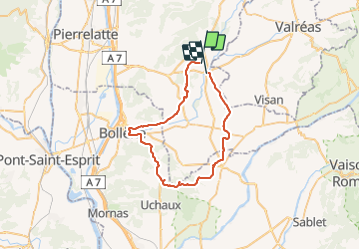
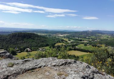
Trail Hybrid bike of 45 km to be discovered at Auvergne-Rhône-Alpes, Drôme, Montségur-sur-Lauzon. This trail is proposed by Philippe.lebrou.

Description

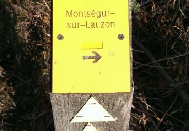
Suite) Les Fangeons / La Garde P./ STE Cécile et retour par les vignes

Elevation profile

Photos

Positioning

Country:
France
Region :
Auvergne-Rhône-Alpes
Department/Province :
Drôme
Municipality :
Montségur-sur-Lauzon
Location:
Unknown
Start:(UTM)
647992 ; 4912176 (31T) N.

Trails nearby

Trail Walking Clansayes - SityTrail - Clansayes Le Rouvergue 6km - Photo
Walking
GUIDE
thonyc

Walking

Easy
(2)
Clansayes, Auvergne-Rhône-Alpes, Drôme, France
7.2 km | 8.4 km-effort
2h 0min
Yes
Trail Walking Montségur-sur-Lauzon - Bassin des druides. Montségur-lauzon - Photo
Walking
Pacekall

Walking

Easy
(1)
Montségur-sur-Lauzon, Auvergne-Rhône-Alpes, Drôme, France
10.7 km | 13.1 km-effort
3h 14min
Yes
Trail Walking Suze-la-Rousse - soleirieu - Photo
Walking
losjo

Walking

Easy
(1)
Suze-la-Rousse, Auvergne-Rhône-Alpes, Drôme, France
11.9 km | 14.7 km-effort
3h 8min
Yes
Trail Walking Clansayes - SityTrail - 2656269 - chantemerle-clansayes-15km - Photo
Walking
GUIDE
thonyc

Walking

Easy
Clansayes, Auvergne-Rhône-Alpes, Drôme, France
12.4 km | 15.8 km-effort
3h 0min
Yes
Trail Walking Clansayes - clansayes - Photo
Walking
cousam

Walking

Medium
(1)
Clansayes, Auvergne-Rhône-Alpes, Drôme, France
9.7 km | 14 km-effort
4h 49min
Yes
Trail Walking Clansayes - 2022-06-24_19h24m07_Clansayes Le Rouvergue 11km.gpx.xml - Photo
Walking
chancha

Walking

Difficult
Clansayes, Auvergne-Rhône-Alpes, Drôme, France
11.1 km | 14.5 km-effort
3h 21min
Yes
Trail Walking Clansayes - 2022-05-26_08h43m46_Clansayes Le Rouvergue 8km.gpx.xml - Photo
Walking
chancha

Walking

Easy
Clansayes, Auvergne-Rhône-Alpes, Drôme, France
7.8 km | 9.3 km-effort
3h 15min
Yes
Trail Walking Chamaret - Borries de chamaret  - Photo
Walking
aitkhedache

Walking

Very easy
Chamaret, Auvergne-Rhône-Alpes, Drôme, France
5.1 km | 6.1 km-effort
2h 23min
Yes
Trail Walking Clansayes - Clansayes  Côte du Serre Chapelle Toronne 7km - Photo
Walking
GUIDE
thonyc

Walking

Very easy
Clansayes, Auvergne-Rhône-Alpes, Drôme, France
7.3 km | 10.3 km-effort
2h 32min
Yes


Close
My subscriptions