![](/images/other/stat-length.png)
![Trail Walking Chailly-en-Bière - CHAILLY EN BIERE - FORET FONTAINEBLEAU - Photo](https://media.geolcdn.com/t/1900/400/ext.pjpeg?maxdim=2&url=https%3A%2F%2Fstatic1.geolcdn.com%2Fsiteimages%2Fupload%2Ffiles%2F1553511878bg_sport_marche.png)
CHAILLY EN BIERE - FORET FONTAINEBLEAU
DUGAEL
User
![Length](/images/other/stat-length.png)
Length
25 km
![Max alt](https://static1.geolcdn.com/siteimages/upload/files/1508320355ic_sort_altitude_max_24dp.png)
Max alt
152 m
![Uphill gradient](https://static1.geolcdn.com/siteimages/upload/files/1508320355ic_sort_den_pos_24dp.png)
Uphill gradient
392 m
![Km-Effort](/images/other/stat-length.png)
Km-Effort
30 km
![Min alt](https://static1.geolcdn.com/siteimages/upload/files/1508320355ic_sort_altitude_min_24dp.png)
Min alt
75 m
![Downhill gradient](https://static1.geolcdn.com/siteimages/upload/files/1508320355ic_sort_den_neg_24dp.png)
Downhill gradient
392 m
![Boucle](https://static1.geolcdn.com/siteimages/upload/files/16400158638029165_repeat_loop_refresh_sync_direction_icon.png)
Boucle
Yes
Creation date :
2021-11-10 16:39:15.591
Updated on :
2021-11-10 16:46:47.175
![Walking](https://static1.geolcdn.com/sitytour/trail-icons/101.png)
6h48
Difficulty : Very difficult
![Scan this QR Code to open this trail in the SityTrail application](https://capi.geolives.com/qq0zvz2zws4bq2lad0pu/sitytour/trails/2998408/qr.png?size=200)
FREE GPS app for hiking
About
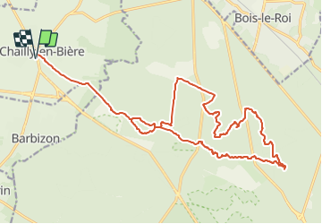
Trail Walking of 25 km to be discovered at Ile-de-France, Seine-et-Marne, Chailly-en-Bière. This trail is proposed by DUGAEL.
Description
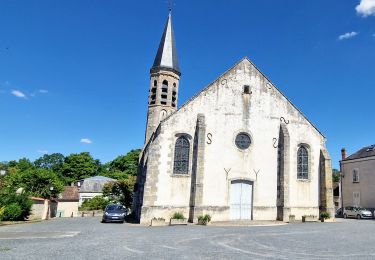
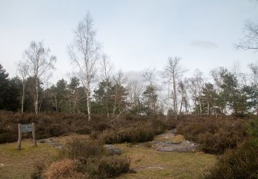
Départ tranquille de Chailly en Bière, puis les rochers de Fontainebleau passage à proximité du rocher Canon et de la grotte aux cristaux
Positioning
Country:
France
Region :
Ile-de-France
Department/Province :
Seine-et-Marne
Municipality :
Chailly-en-Bière
Location:
Unknown
Start:(Dec)
Start:(UTM)
470940 ; 5368050 (31U) N.
Comments
Trails nearby
![Trail Walking Barbizon - Sentier des peintres - Photo](https://media.geolcdn.com/t/375/260/ext.jpg?maxdim=2&url=https%3A%2F%2Fservices.sitytrail.com%2FGeolivesWS%2FDownloadMedia.ashx%3FTrailID%3D188736%26Media%3D187396bd-9ee4-4169-9310-5793d2588587.jpeg)
![Walking Walking](https://static1.geolcdn.com/sitytour/trail-icons/101.png)
Sentier des peintres
Walking
Medium
(11)
Barbizon,
Ile-de-France,
Seine-et-Marne,
France
![](/images/other/stat-length.png)
7.5 km | 8.2 km-effort
1h 25min
![](https://static1.geolcdn.com/siteimages/upload/files/16400158638029165_repeat_loop_refresh_sync_direction_icon.png)
Yes
![Trail Walking Fontainebleau - Sur les traces de Césaire Sempité - Fontainebleau rocher canon - Photo](https://media.geolcdn.com/t/375/260/b9aa5b48-fd03-4263-8213-67fa0706433b.jpg&format=jpg&maxdim=2)
![Walking Walking](https://static1.geolcdn.com/sitytour/trail-icons/101.png)
Sur les traces de Césaire Sempité - Fontainebleau rocher canon
Walking
Easy
(1)
Fontainebleau,
Ile-de-France,
Seine-et-Marne,
France
![](/images/other/stat-length.png)
17.3 km | 21 km-effort
4h 8min
![](https://static1.geolcdn.com/siteimages/upload/files/16400158638029165_repeat_loop_refresh_sync_direction_icon.png)
Yes
![Trail Walking Fontainebleau - 3pi-150428 - DésertApremont-Jupiter - Photo](https://media.geolcdn.com/t/375/260/ext.jpg?maxdim=2&url=https%3A%2F%2Fservices.sitytrail.com%2FGeolivesWS%2FDownloadMedia.ashx%3FTrailID%3D414037%26Media%3D22942274-9308-46bb-bc6d-06c82c3e8751.jpg)
![Walking Walking](https://static1.geolcdn.com/sitytour/trail-icons/101.png)
3pi-150428 - DésertApremont-Jupiter
Walking
Easy
(1)
Fontainebleau,
Ile-de-France,
Seine-et-Marne,
France
![](/images/other/stat-length.png)
16 km | 19.4 km-effort
6h 30min
![](https://static1.geolcdn.com/siteimages/upload/files/16400158638029165_repeat_loop_refresh_sync_direction_icon.png)
Yes
![Trail Walking Fontainebleau - Boucle Barbizon - Arbonne 26 km - Photo](https://media.geolcdn.com/t/375/260/d3a133ff-ea77-47a6-826a-54bbe45391c4.jpg&format=jpg&maxdim=2)
![Walking Walking](https://static1.geolcdn.com/sitytour/trail-icons/101.png)
Boucle Barbizon - Arbonne 26 km
Walking
Medium
Fontainebleau,
Ile-de-France,
Seine-et-Marne,
France
![](/images/other/stat-length.png)
26 km | 30 km-effort
5h 6min
![](https://static1.geolcdn.com/siteimages/upload/files/16400158638029165_repeat_loop_refresh_sync_direction_icon.png)
Yes
![Trail On foot Fontainebleau - Fontainebleau les monts de Fay - Photo](https://media.geolcdn.com/t/375/260/44c84e7a-206d-494a-bf60-bcd1709cbc23.jpg&format=jpg&maxdim=2)
![On foot On foot](https://static1.geolcdn.com/sitytour/trail-icons/100.png)
Fontainebleau les monts de Fay
On foot
Medium
Fontainebleau,
Ile-de-France,
Seine-et-Marne,
France
![](/images/other/stat-length.png)
22 km | 27 km-effort
6h 12min
![](https://static1.geolcdn.com/siteimages/upload/files/16400158638029165_repeat_loop_refresh_sync_direction_icon.png)
Yes
![Trail Walking Fontainebleau - Boucle Fontainebleau - Photo](https://media.geolcdn.com/t/375/260/17f2c6e1-3b09-4e9b-8122-f375fab45f61.jpg&format=jpg&maxdim=2)
![Walking Walking](https://static1.geolcdn.com/sitytour/trail-icons/101.png)
Boucle Fontainebleau
Walking
Medium
Fontainebleau,
Ile-de-France,
Seine-et-Marne,
France
![](/images/other/stat-length.png)
29 km | 34 km-effort
5h 49min
![](https://static1.geolcdn.com/siteimages/upload/files/16400158638029165_repeat_loop_refresh_sync_direction_icon.png)
Yes
![Trail Walking Barbizon - Le tour du Grand Paris via le GR1 etape 14 Barbizon- Malesherbes - Photo](https://media.geolcdn.com/t/375/260/8af1b7ac-6c06-4a51-9474-d487076c1a9a.jpg&format=jpg&maxdim=2)
![Walking Walking](https://static1.geolcdn.com/sitytour/trail-icons/101.png)
Le tour du Grand Paris via le GR1 etape 14 Barbizon- Malesherbes
Walking
Very difficult
Barbizon,
Ile-de-France,
Seine-et-Marne,
France
![](/images/other/stat-length.png)
35 km | 41 km-effort
6h 11min
![](https://static1.geolcdn.com/siteimages/upload/files/16400158638029165_repeat_loop_refresh_sync_direction_icon.png)
No
![Trail On foot Barbizon - Liaison Fontainebleau-Barbizon - Photo](https://media.geolcdn.com/t/375/260/130ed359-0dda-438a-aa1d-a20b2f4ac16e.jpeg&format=jpg&maxdim=2)
![On foot On foot](https://static1.geolcdn.com/sitytour/trail-icons/100.png)
Liaison Fontainebleau-Barbizon
On foot
Easy
Barbizon,
Ile-de-France,
Seine-et-Marne,
France
![](/images/other/stat-length.png)
9.9 km | 11.3 km-effort
2h 33min
![](https://static1.geolcdn.com/siteimages/upload/files/16400158638029165_repeat_loop_refresh_sync_direction_icon.png)
No
![Trail On foot Fontainebleau - Sentier Denecourt-Colinet 6 - Photo](https://media.geolcdn.com/t/375/260/84fa17bd-598b-4ebd-b9b0-c63398cc2d74.jpeg&format=jpg&maxdim=2)
![On foot On foot](https://static1.geolcdn.com/sitytour/trail-icons/100.png)
Sentier Denecourt-Colinet 6
On foot
Easy
(1)
Fontainebleau,
Ile-de-France,
Seine-et-Marne,
France
![](/images/other/stat-length.png)
4.4 km | 5.5 km-effort
1h 15min
![](https://static1.geolcdn.com/siteimages/upload/files/16400158638029165_repeat_loop_refresh_sync_direction_icon.png)
No