![](/images/other/stat-length.png)
![Trail Walking Trilport - La Vallée de la Marne entre le Canal de l'Ourcq et la Forêt de Monceaux - Photo](https://media.geolcdn.com/t/1900/400/ext.pjpeg?maxdim=2&url=https%3A%2F%2Fmedia.geolcdn.com%2Ff%2Fa8d3329b-f915-40ee-a788-426eddacf54a.jpg)
La Vallée de la Marne entre le Canal de l'Ourcq et la Forêt de Monceaux
Les 1000 pattes
Club randonnées SERVON
![Length](/images/other/stat-length.png)
Length
20 km
![Max alt](https://static1.geolcdn.com/siteimages/upload/files/1508320355ic_sort_altitude_max_24dp.png)
Max alt
121 m
![Uphill gradient](https://static1.geolcdn.com/siteimages/upload/files/1508320355ic_sort_den_pos_24dp.png)
Uphill gradient
205 m
![Km-Effort](/images/other/stat-length.png)
Km-Effort
23 km
![Min alt](https://static1.geolcdn.com/siteimages/upload/files/1508320355ic_sort_altitude_min_24dp.png)
Min alt
44 m
![Downhill gradient](https://static1.geolcdn.com/siteimages/upload/files/1508320355ic_sort_den_neg_24dp.png)
Downhill gradient
205 m
![Boucle](https://static1.geolcdn.com/siteimages/upload/files/16400158638029165_repeat_loop_refresh_sync_direction_icon.png)
Boucle
Yes
Creation date :
2021-11-08 10:23:50.017
Updated on :
2021-11-13 13:32:50.556
![Walking](https://static1.geolcdn.com/sitytour/trail-icons/101.png)
5h09
Difficulty : Difficult
![Scan this QR Code to open this trail in the SityTrail application](https://capi.geolives.com/qq0zvz2zws4bq2lad0pu/sitytour/trails/2996060/qr.png?size=200)
FREE GPS app for hiking
About
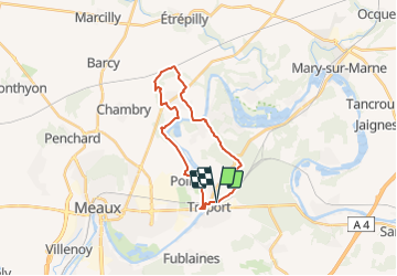
Trail Walking of 20 km to be discovered at Ile-de-France, Seine-et-Marne, Trilport. This trail is proposed by Les 1000 pattes.
Description
Parking de la gare Rue du Chêne au Roi à Trilport
Trajet Servon-->Trilport (54km: 1h)
Positioning
Country:
France
Region :
Ile-de-France
Department/Province :
Seine-et-Marne
Municipality :
Trilport
Location:
Unknown
Start:(Dec)
Start:(UTM)
496489 ; 5423059 (31U) N.
Comments
Trails nearby
![Trail Mountain bike Nanteuil-lès-Meaux - tite boucle Nanteuil par l'eau - Photo](https://media.geolcdn.com/t/375/260/ext.jpg?maxdim=2&url=https%3A%2F%2Fservices.sitytrail.com%2FGeolivesWS%2FDownloadMedia.ashx%3FTrailID%3D263705%26Media%3Dfix__20140406122359.jpg)
![Mountain bike Mountain bike](https://static1.geolcdn.com/sitytour/trail-icons/202.png)
tite boucle Nanteuil par l'eau
Mountain bike
Easy
(1)
Nanteuil-lès-Meaux,
Ile-de-France,
Seine-et-Marne,
France
![](/images/other/stat-length.png)
23 km | 26 km-effort
1h 48min
![](https://static1.geolcdn.com/siteimages/upload/files/16400158638029165_repeat_loop_refresh_sync_direction_icon.png)
Yes
![Trail Walking Meaux - SM_MEAUX_LePâtis_8km. - Photo](https://media.geolcdn.com/t/375/260/ext.jpg?maxdim=2&url=https%3A%2F%2Fmedia.geolcdn.com%2Ff%2F59d59af8-64ac-4cd9-8525-6af37371405a.jpg)
![Walking Walking](https://static1.geolcdn.com/sitytour/trail-icons/101.png)
SM_MEAUX_LePâtis_8km.
Walking
Easy
(3)
Meaux,
Ile-de-France,
Seine-et-Marne,
France
![](/images/other/stat-length.png)
7.9 km | 8.4 km-effort
1h 54min
![](https://static1.geolcdn.com/siteimages/upload/files/16400158638029165_repeat_loop_refresh_sync_direction_icon.png)
Yes
![Trail Walking Meaux - Canal autour de Meaux - Photo](https://media.geolcdn.com/t/375/260/ext.jpg?maxdim=2&url=https%3A%2F%2Fstatic1.geolcdn.com%2Fsiteimages%2Fupload%2Ffiles%2F1553511878bg_sport_marche.png)
![Walking Walking](https://static1.geolcdn.com/sitytour/trail-icons/101.png)
Canal autour de Meaux
Walking
Easy
(1)
Meaux,
Ile-de-France,
Seine-et-Marne,
France
![](/images/other/stat-length.png)
11.4 km | 12.3 km-effort
2h 51min
![](https://static1.geolcdn.com/siteimages/upload/files/16400158638029165_repeat_loop_refresh_sync_direction_icon.png)
Yes
![Trail Walking Chambry - Chambry Grand Parcours - Photo](https://media.geolcdn.com/t/375/260/ext.jpg?maxdim=2&url=https%3A%2F%2Fstatic1.geolcdn.com%2Fsiteimages%2Fupload%2Ffiles%2F1553511878bg_sport_marche.png)
![Walking Walking](https://static1.geolcdn.com/sitytour/trail-icons/101.png)
Chambry Grand Parcours
Walking
Easy
(2)
Chambry,
Ile-de-France,
Seine-et-Marne,
France
![](/images/other/stat-length.png)
18.3 km | 20 km-effort
4h 29min
![](https://static1.geolcdn.com/siteimages/upload/files/16400158638029165_repeat_loop_refresh_sync_direction_icon.png)
Yes
![Trail Walking Germigny-l'Évêque - ballade en forêt de montceaux - Photo](https://media.geolcdn.com/t/375/260/ext.jpg?maxdim=2&url=https%3A%2F%2Fstatic1.geolcdn.com%2Fsiteimages%2Fupload%2Ffiles%2F1553511878bg_sport_marche.png)
![Walking Walking](https://static1.geolcdn.com/sitytour/trail-icons/101.png)
ballade en forêt de montceaux
Walking
Very easy
(1)
Germigny-l'Évêque,
Ile-de-France,
Seine-et-Marne,
France
![](/images/other/stat-length.png)
5 km | 5.8 km-effort
1h 23min
![](https://static1.geolcdn.com/siteimages/upload/files/16400158638029165_repeat_loop_refresh_sync_direction_icon.png)
Yes
![Trail Running Meaux - Meaux Condorcet - Photo](https://media.geolcdn.com/t/375/260/ext.jpg?maxdim=2&url=https%3A%2F%2Fstatic1.geolcdn.com%2Fsiteimages%2Fupload%2Ffiles%2F1524743154running.jpg)
![Running Running](https://static1.geolcdn.com/sitytour/trail-icons/103.png)
Meaux Condorcet
Running
Very easy
(2)
Meaux,
Ile-de-France,
Seine-et-Marne,
France
![](/images/other/stat-length.png)
11.5 km | 12.5 km-effort
1h 0min
![](https://static1.geolcdn.com/siteimages/upload/files/16400158638029165_repeat_loop_refresh_sync_direction_icon.png)
Yes
![Trail Walking Meaux - Le Parc naturel du Pâtis - Photo](https://media.geolcdn.com/t/375/260/ext.jpg?maxdim=2&url=https%3A%2F%2Fstatic1.geolcdn.com%2Fsiteimages%2Fupload%2Ffiles%2F1553511878bg_sport_marche.png)
![Walking Walking](https://static1.geolcdn.com/sitytour/trail-icons/101.png)
Le Parc naturel du Pâtis
Walking
Easy
(1)
Meaux,
Ile-de-France,
Seine-et-Marne,
France
![](/images/other/stat-length.png)
12.5 km | 13.4 km-effort
2h 58min
![](https://static1.geolcdn.com/siteimages/upload/files/16400158638029165_repeat_loop_refresh_sync_direction_icon.png)
Yes
![Trail Walking Meaux - Meaux - Photo](https://media.geolcdn.com/t/375/260/ext.jpg?maxdim=2&url=https%3A%2F%2Fservices.sitytrail.com%2FGeolivesWS%2FDownloadMedia.ashx%3FTrailID%3D537396%26Media%3Dfix__20160313155127.jpg)
![Walking Walking](https://static1.geolcdn.com/sitytour/trail-icons/101.png)
![Trail Walking Trilport - Trilport - Photo](https://media.geolcdn.com/t/375/260/ext.jpg?maxdim=2&url=https%3A%2F%2Fservices.sitytrail.com%2FGeolivesWS%2FDownloadMedia.ashx%3FTrailID%3D310436%26Media%3Dfix__20140608160004.jpg)
![Walking Walking](https://static1.geolcdn.com/sitytour/trail-icons/101.png)
Trilport
Walking
Easy
(1)
Trilport,
Ile-de-France,
Seine-et-Marne,
France
![](/images/other/stat-length.png)
19.5 km | 21 km-effort
4h 42min
![](https://static1.geolcdn.com/siteimages/upload/files/16400158638029165_repeat_loop_refresh_sync_direction_icon.png)
Yes