![](/images/other/stat-length.png)
![Trail Walking Crécy-la-Chapelle - Crecy-la-Chapelle - Photo](https://media.geolcdn.com/t/1900/400/9291d24c-6308-491b-ab2e-0d21d3baa9de.jpg&format=pjpeg&maxdim=2)
Crecy-la-Chapelle
Les 1000 pattes
Club randonnées SERVON
![Length](/images/other/stat-length.png)
Length
16.1 km
![Max alt](https://static1.geolcdn.com/siteimages/upload/files/1508320355ic_sort_altitude_max_24dp.png)
Max alt
130 m
![Uphill gradient](https://static1.geolcdn.com/siteimages/upload/files/1508320355ic_sort_den_pos_24dp.png)
Uphill gradient
217 m
![Km-Effort](/images/other/stat-length.png)
Km-Effort
18.9 km
![Min alt](https://static1.geolcdn.com/siteimages/upload/files/1508320355ic_sort_altitude_min_24dp.png)
Min alt
47 m
![Downhill gradient](https://static1.geolcdn.com/siteimages/upload/files/1508320355ic_sort_den_neg_24dp.png)
Downhill gradient
217 m
![Boucle](https://static1.geolcdn.com/siteimages/upload/files/16400158638029165_repeat_loop_refresh_sync_direction_icon.png)
Boucle
Yes
Creation date :
2021-11-08 10:05:39.922
Updated on :
2023-07-18 13:46:48.439
![Walking](https://static1.geolcdn.com/sitytour/trail-icons/101.png)
4h18
Difficulty : Difficult
![Scan this QR Code to open this trail in the SityTrail application](https://capi.geolives.com/qq0zvz2zws4bq2lad0pu/sitytour/trails/2996039/qr.png?size=200)
FREE GPS app for hiking
About
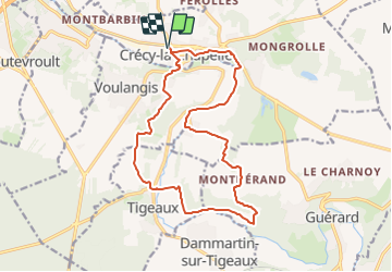
Trail Walking of 16.1 km to be discovered at Ile-de-France, Seine-et-Marne, Crécy-la-Chapelle. This trail is proposed by Les 1000 pattes.
Description
Parking Avenue de la Gare de Crécy la Chapelle
Trajet Servon-->Crécy la Chapelle (39km: 30mn)
La Venise briarde avec les brassets du Grand Morin (les canaux)
La collégiale Notre Dame de l'Assomption
Positioning
Country:
France
Region :
Ile-de-France
Department/Province :
Seine-et-Marne
Municipality :
Crécy-la-Chapelle
Location:
Unknown
Start:(Dec)
Start:(UTM)
493130 ; 5411822 (31U) N.
Comments
Trails nearby
![Trail Walking Crécy-la-Chapelle - Boucle 28 km autour de Crecy la Chapelle - Guérard - Voulangis - Tigeaux - Photo](https://media.geolcdn.com/t/375/260/ec792934-9951-48a4-9c10-6a048c9ff4d6.jpg&format=jpg&maxdim=2)
![Walking Walking](https://static1.geolcdn.com/sitytour/trail-icons/101.png)
Boucle 28 km autour de Crecy la Chapelle - Guérard - Voulangis - Tigeaux
Walking
Medium
Crécy-la-Chapelle,
Ile-de-France,
Seine-et-Marne,
France
![](/images/other/stat-length.png)
28 km | 35 km-effort
5h 46min
![](https://static1.geolcdn.com/siteimages/upload/files/16400158638029165_repeat_loop_refresh_sync_direction_icon.png)
Yes
![Trail Walking Crécy-la-Chapelle - Crécy la Chapelle Parcours normal - Photo](https://media.geolcdn.com/t/375/260/ext.jpg?maxdim=2&url=https%3A%2F%2Fstatic1.geolcdn.com%2Fsiteimages%2Fupload%2Ffiles%2F1553511878bg_sport_marche.png)
![Walking Walking](https://static1.geolcdn.com/sitytour/trail-icons/101.png)
Crécy la Chapelle Parcours normal
Walking
Easy
(1)
Crécy-la-Chapelle,
Ile-de-France,
Seine-et-Marne,
France
![](/images/other/stat-length.png)
16.1 km | 19.5 km-effort
4h 18min
![](https://static1.geolcdn.com/siteimages/upload/files/16400158638029165_repeat_loop_refresh_sync_direction_icon.png)
Yes
![Trail Walking Crécy-la-Chapelle - Crécy la chapelle - Photo](https://media.geolcdn.com/t/375/260/ext.jpg?maxdim=2&url=https%3A%2F%2Fstatic1.geolcdn.com%2Fsiteimages%2Fupload%2Ffiles%2F1553511878bg_sport_marche.png)
![Walking Walking](https://static1.geolcdn.com/sitytour/trail-icons/101.png)
Crécy la chapelle
Walking
Easy
(2)
Crécy-la-Chapelle,
Ile-de-France,
Seine-et-Marne,
France
![](/images/other/stat-length.png)
19.7 km | 24 km-effort
5h 12min
![](https://static1.geolcdn.com/siteimages/upload/files/16400158638029165_repeat_loop_refresh_sync_direction_icon.png)
Yes
![Trail Walking Crécy-la-Chapelle - Crécy la Chapelle - Photo](https://media.geolcdn.com/t/375/260/ext.jpg?maxdim=2&url=https%3A%2F%2Fstatic1.geolcdn.com%2Fsiteimages%2Fupload%2Ffiles%2F1553511878bg_sport_marche.png)
![Walking Walking](https://static1.geolcdn.com/sitytour/trail-icons/101.png)
Crécy la Chapelle
Walking
Medium
(1)
Crécy-la-Chapelle,
Ile-de-France,
Seine-et-Marne,
France
![](/images/other/stat-length.png)
16.4 km | 20 km-effort
4h 23min
![](https://static1.geolcdn.com/siteimages/upload/files/16400158638029165_repeat_loop_refresh_sync_direction_icon.png)
Yes
![Trail Walking Crécy-la-Chapelle - Autour de Tigeaux - Photo](https://media.geolcdn.com/t/375/260/ext.jpg?maxdim=2&url=https%3A%2F%2Fstatic1.geolcdn.com%2Fsiteimages%2Fupload%2Ffiles%2F1553511878bg_sport_marche.png)
![Walking Walking](https://static1.geolcdn.com/sitytour/trail-icons/101.png)
Autour de Tigeaux
Walking
Medium
(2)
Crécy-la-Chapelle,
Ile-de-France,
Seine-et-Marne,
France
![](/images/other/stat-length.png)
13.2 km | 16.5 km-effort
2h 37min
![](https://static1.geolcdn.com/siteimages/upload/files/16400158638029165_repeat_loop_refresh_sync_direction_icon.png)
Yes
![Trail Walking Voulangis - Voulangis - Crécy - Villiers lqqm - Photo](https://media.geolcdn.com/t/375/260/ext.jpg?maxdim=2&url=https%3A%2F%2Fstatic1.geolcdn.com%2Fsiteimages%2Fupload%2Ffiles%2F1553511878bg_sport_marche.png)
![Walking Walking](https://static1.geolcdn.com/sitytour/trail-icons/101.png)
Voulangis - Crécy - Villiers lqqm
Walking
Difficult
(1)
Voulangis,
Ile-de-France,
Seine-et-Marne,
France
![](/images/other/stat-length.png)
12.9 km | 15.7 km-effort
3h 34min
![](https://static1.geolcdn.com/siteimages/upload/files/16400158638029165_repeat_loop_refresh_sync_direction_icon.png)
Yes
![Trail Walking Voulangis - Voulangis - Crécy - Villiers - Photo](https://media.geolcdn.com/t/375/260/ext.jpg?maxdim=2&url=https%3A%2F%2Fstatic1.geolcdn.com%2Fsiteimages%2Fupload%2Ffiles%2F1553511878bg_sport_marche.png)
![Walking Walking](https://static1.geolcdn.com/sitytour/trail-icons/101.png)
Voulangis - Crécy - Villiers
Walking
Difficult
(1)
Voulangis,
Ile-de-France,
Seine-et-Marne,
France
![](/images/other/stat-length.png)
12.9 km | 15.7 km-effort
3h 34min
![](https://static1.geolcdn.com/siteimages/upload/files/16400158638029165_repeat_loop_refresh_sync_direction_icon.png)
Yes
![Trail Walking Guérard - Guérard - Photo](https://media.geolcdn.com/t/375/260/604a5cf1-31c1-4e64-b7ed-ed1e6e2756f8.jpg&format=jpg&maxdim=2)
![Walking Walking](https://static1.geolcdn.com/sitytour/trail-icons/101.png)
Guérard
Walking
Difficult
Guérard,
Ile-de-France,
Seine-et-Marne,
France
![](/images/other/stat-length.png)
15.4 km | 18.5 km-effort
4h 3min
![](https://static1.geolcdn.com/siteimages/upload/files/16400158638029165_repeat_loop_refresh_sync_direction_icon.png)
Yes
![Trail Walking Tigeaux - Tigeaux - Photo](https://media.geolcdn.com/t/375/260/ext.jpg?maxdim=2&url=https%3A%2F%2Fstatic1.geolcdn.com%2Fsiteimages%2Fupload%2Ffiles%2F1553511878bg_sport_marche.png)
![Walking Walking](https://static1.geolcdn.com/sitytour/trail-icons/101.png)
Tigeaux
Walking
Medium
(1)
Tigeaux,
Ile-de-France,
Seine-et-Marne,
France
![](/images/other/stat-length.png)
19.1 km | 24 km-effort
5h 24min
![](https://static1.geolcdn.com/siteimages/upload/files/16400158638029165_repeat_loop_refresh_sync_direction_icon.png)
Yes