38 km | 45 km-effort
06/11/21
© OpenStreetMap contributors
Walking
2h04
Difficulty : Difficult
Length
11 km
Max alt
401 m
Uphill gradient
167 m
Km-Effort
13.2 km
Min alt
308 m
Downhill gradient
169 m
Boucle
Yes
Creation date :
2021-11-06 13:25:12.142
Updated on :
2021-11-06 15:30:39.358
2h04
Difficulty : Difficult
FREE GPS app for hiking
About
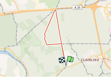
Trail Walking of 11 km to be discovered at Grand Est, Meurthe-et-Moselle, Chaligny. This trail is proposed by jerome-dupont@laposte.net.
Description
marche rapide mais.forest.- six bornes-autoroute direct
Positioning
Country:
France
Region :
Grand Est
Department/Province :
Meurthe-et-Moselle
Municipality :
Chaligny
Location:
Unknown
Start:(Dec)
Start:(UTM)
285339 ; 5392766 (32U) N.
Comments
Trails nearby
RANDO DUO AVEC ALEXIS
Walking
Difficult
(1)
Villers-lès-Nancy,
Grand Est,
Meurthe-et-Moselle,
France
10h 19min
No
Sexey Aux Forges
Walking
Very difficult
Sexey-aux-Forges,
Grand Est,
Meurthe-et-Moselle,
France
31 km | 38 km-effort
2h 38min
No
Promenade d'Hardeval
On foot
Easy
Villers-lès-Nancy,
Grand Est,
Meurthe-et-Moselle,
France
3.2 km | 4.3 km-effort
58min
Yes
Chaligny 1
Walking
Easy
(1)
Chaligny,
Grand Est,
Meurthe-et-Moselle,
France
4.9 km | 6.3 km-effort
1h 20min
Yes
la rapine
Walking
Very easy
Nancy,
Grand Est,
Meurthe-et-Moselle,
France
9.4 km | 11.7 km-effort
Unknown
Yes
auda
Walking
Very difficult
Neuves-Maisons,
Grand Est,
Meurthe-et-Moselle,
France
25 km | 28 km-effort
4h 30min
Yes
Le chemin des mines
Walking
Difficult
Pont-Saint-Vincent,
Grand Est,
Meurthe-et-Moselle,
France
13 km | 16.6 km-effort
3h 39min
Yes
clairlieu villers
Walking
Easy
Villers-lès-Nancy,
Grand Est,
Meurthe-et-Moselle,
France
6.6 km | 8 km-effort
2h 18min
Yes
Famille
Walking
Easy
Villers-lès-Nancy,
Grand Est,
Meurthe-et-Moselle,
France
3.2 km | 4.2 km-effort
1h 2min
No