Trail Walking Isola - Col de la Guercha - Photo
 bozo1970
bozo1970

User

© OpenStreetMap contributors
Length
Length
11.3 km
Max alt
Max alt
2455 m
Uphill gradient
Uphill gradient
1195 m
Km-Effort
Km-Effort  
27 km
Min alt
Min alt
1254 m
Downhill gradient
Downhill gradient
1191 m
Boucle
Boucle
Yes
Creation date :
2021-11-04 08:06:10.0
Updated on :
2021-11-04 16:38:26.352

(0 Reviews)

Walking
Walking
5h04
Difficulty : Very difficult

Scan this QR Code to open this trail in the SityTrail application

FREE GPS app for hiking

Logo SityTrail SityTrail

IGN / Geographical institutes

Download SityTrail from the App Store Download SityTrail from Google Play

Logo SityTrail SityTrail World

The world is yours!

Download SityTrail from the App Store Download SityTrail from Google Play Download SityTrail on Huawei AppGallery

About

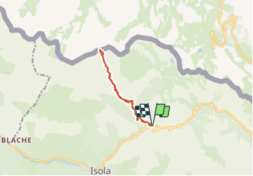
Trail Walking of 11.3 km to be discovered at Provence-Alpes-Côte d'Azur, Maritime Alps, Isola. This trail is proposed by bozo1970.

Description

Départ de la route d’Isola 2000, balise 60
Montée par le vallon de la Guercha et le vallon de la cabane moutons
Sentier très mal tracé, mal cairné, la totale
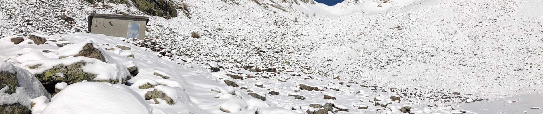
Début de la neige vers 2000m
PREMIÈRE NEIGE  de la saison !!
Arrivée au col de la Guercha à 2456m d’altitude en 3h05’ avec un D  de 1200m et 6km
Avec Hip-hop ( belle performance pour ses 9 ans ! )
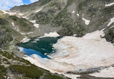
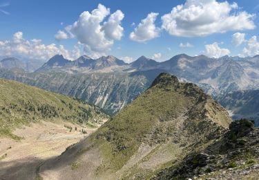
Très belle ligne de crête vers le pas du bœuf et le col de Saboulé

Elevation profile

Photos

Positioning

Country:
France
Region :
Provence-Alpes-Côte d'Azur
Department/Province :
Maritime Alps
Municipality :
Isola
Location:
Unknown
Start:(UTM)
346401 ; 4896087 (32T) N.

Trails nearby

Trail Walking Isola - Châtaigneraie ISOLA - Photo
Walking
jpnice06

Walking

Very easy
(1)
Isola, Provence-Alpes-Côte d'Azur, Maritime Alps, France
4.4 km | 7.1 km-effort
2h 9min
Yes
Trail On foot Vinadio - Tour du Lausfer - Photo
On foot
GUIDE+

On foot

Easy
Vinadio, Piemont, Cuneo, Italy
9.5 km | 16.7 km-effort
3h 47min
Yes
Trail On foot Vinadio - (SI E13) Sant'Anna di Vinadio - Vinadio Frazione Strepeis - Photo
On foot
GUIDE+

On foot

Easy
Vinadio, Piemont, Cuneo, Italy
9.1 km | 16.1 km-effort
3h 40min
No
Trail Walking Vinadio - Tour du Lausfer 25.8.24 - Photo
Walking
GUIDE
fredetpascale

Walking

Medium
Vinadio, Piemont, Cuneo, Italy
9 km | 16.2 km-effort
3h 30min
Yes
Trail sport Vinadio - Lacs de laisser - Photo
sport
GUIDE
jouans

sport

Very easy
Vinadio, Piemont, Cuneo, Italy
12.4 km | 21 km-effort
Unknown
Yes
Trail Walking Isola - Fontaine St Laurent par Collet de Léchio et Cascade de Louch Isola Village - Photo
Walking
GrouGary

Walking

Easy
Isola, Provence-Alpes-Côte d'Azur, Maritime Alps, France
9.5 km | 16.3 km-effort
4h 44min
Yes
Trail Snowshoes Isola - Mont St Sauveur  - Photo
Snowshoes
bozo1970

Snowshoes

Difficult
Isola, Provence-Alpes-Côte d'Azur, Maritime Alps, France
8.7 km | 20 km-effort
3h 52min
Yes
Trail Walking Isola - Lacs du Lausfer / pas de Ste Anne - Photo
Walking
bozo1970

Walking

Easy
Isola, Provence-Alpes-Côte d'Azur, Maritime Alps, France
9.7 km | 20 km-effort
3h 9min
Yes
Trail Walking Isola - Cîme de Sistron - Photo
Walking
bozo1970

Walking

Medium
Isola, Provence-Alpes-Côte d'Azur, Maritime Alps, France
10.2 km | 21 km-effort
3h 27min
Yes


Close
My subscriptions