![](/images/other/stat-length.png)
![Trail Walking Palaiseau - Palaiseau Orsay Les Ulis Bures - Photo](https://media.geolcdn.com/t/1900/400/ext.pjpeg?maxdim=2&url=https%3A%2F%2Fstatic1.geolcdn.com%2Fsiteimages%2Fupload%2Ffiles%2F1553511878bg_sport_marche.png)
Palaiseau Orsay Les Ulis Bures
philippebenne
User
![Length](/images/other/stat-length.png)
Length
17.4 km
![Max alt](https://static1.geolcdn.com/siteimages/upload/files/1508320355ic_sort_altitude_max_24dp.png)
Max alt
171 m
![Uphill gradient](https://static1.geolcdn.com/siteimages/upload/files/1508320355ic_sort_den_pos_24dp.png)
Uphill gradient
331 m
![Km-Effort](/images/other/stat-length.png)
Km-Effort
22 km
![Min alt](https://static1.geolcdn.com/siteimages/upload/files/1508320355ic_sort_altitude_min_24dp.png)
Min alt
54 m
![Downhill gradient](https://static1.geolcdn.com/siteimages/upload/files/1508320355ic_sort_den_neg_24dp.png)
Downhill gradient
331 m
![Boucle](https://static1.geolcdn.com/siteimages/upload/files/16400158638029165_repeat_loop_refresh_sync_direction_icon.png)
Boucle
Yes
Creation date :
2021-11-03 17:30:32.039
Updated on :
2022-05-06 16:37:50.512
![Walking](https://static1.geolcdn.com/sitytour/trail-icons/101.png)
5h00
Difficulty : Difficult
![Scan this QR Code to open this trail in the SityTrail application](https://capi.geolives.com/qq0zvz2zws4bq2lad0pu/sitytour/trails/2991822/qr.png?size=200)
FREE GPS app for hiking
About
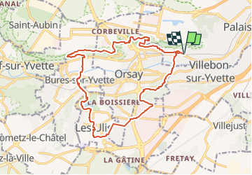
Trail Walking of 17.4 km to be discovered at Ile-de-France, Essonne, Palaiseau. This trail is proposed by philippebenne.
Description
Randonnée variée, permettant de découvrir des environnements divers : Villes et villages traditionnels du Hurepoix, une ville nouvelle, le campus de l'université Paris Saclay, des parcs urbains, le tout dans un cadre très boisé et vallonné.
Positioning
Country:
France
Region :
Ile-de-France
Department/Province :
Essonne
Municipality :
Palaiseau
Location:
Unknown
Start:(Dec)
Start:(UTM)
442229 ; 5395027 (31U) N.
Comments
Trails nearby
![Trail Walking Palaiseau - De Lozere à Gif sur Yvette - Photo](https://media.geolcdn.com/t/375/260/ext.jpg?maxdim=2&url=https%3A%2F%2Fservices.sitytrail.com%2FGeolivesWS%2FDownloadMedia.ashx%3FTrailID%3D106655%26Media%3D11272_3.jpg)
![Walking Walking](https://static1.geolcdn.com/sitytour/trail-icons/101.png)
De Lozere à Gif sur Yvette
Walking
Medium
(1)
Palaiseau,
Ile-de-France,
Essonne,
France
![](/images/other/stat-length.png)
21 km | 28 km-effort
5h 0min
![](https://static1.geolcdn.com/siteimages/upload/files/16400158638029165_repeat_loop_refresh_sync_direction_icon.png)
Yes
![Trail Walking Saulx-les-Chartreux - Saulx les Chartreux vers Ville du Bois - Photo](https://media.geolcdn.com/t/375/260/ext.jpg?maxdim=2&url=https%3A%2F%2Fservices.sitytrail.com%2FGeolivesWS%2FDownloadMedia.ashx%3FTrailID%3D103772%26Media%3D6532_3.jpg)
![Walking Walking](https://static1.geolcdn.com/sitytour/trail-icons/101.png)
Saulx les Chartreux vers Ville du Bois
Walking
Medium
(1)
Saulx-les-Chartreux,
Ile-de-France,
Essonne,
France
![](/images/other/stat-length.png)
9.6 km | 12.2 km-effort
2h 30min
![](https://static1.geolcdn.com/siteimages/upload/files/16400158638029165_repeat_loop_refresh_sync_direction_icon.png)
Yes
![Trail Walking Bures-sur-Yvette - PR 9 Fauvettes - Photo](https://media.geolcdn.com/t/375/260/6ae1ebaa-226a-4e65-b5c2-412630c69abc.jpg&format=jpg&maxdim=2)
![Walking Walking](https://static1.geolcdn.com/sitytour/trail-icons/101.png)
PR 9 Fauvettes
Walking
Very easy
(1)
Bures-sur-Yvette,
Ile-de-France,
Essonne,
France
![](/images/other/stat-length.png)
6.6 km | 8.5 km-effort
2h 3min
![](https://static1.geolcdn.com/siteimages/upload/files/16400158638029165_repeat_loop_refresh_sync_direction_icon.png)
Yes
![Trail Walking Orsay - Le long de l yvette - Photo](https://media.geolcdn.com/t/375/260/ext.jpg?maxdim=2&url=https%3A%2F%2Fservices.sitytrail.com%2FGeolivesWS%2FDownloadMedia.ashx%3FTrailID%3D427704%26Media%3Dfix__20150530150046.jpg)
![Walking Walking](https://static1.geolcdn.com/sitytour/trail-icons/101.png)
Le long de l yvette
Walking
Very easy
(1)
Orsay,
Ile-de-France,
Essonne,
France
![](/images/other/stat-length.png)
8.5 km | 9.4 km-effort
2h 43min
![](https://static1.geolcdn.com/siteimages/upload/files/16400158638029165_repeat_loop_refresh_sync_direction_icon.png)
Yes
![Trail Walking Orsay - Orsay Campus - Photo](https://media.geolcdn.com/t/375/260/ext.jpg?maxdim=2&url=https%3A%2F%2Fservices.sitytrail.com%2FGeolivesWS%2FDownloadMedia.ashx%3FTrailID%3D103330%26Media%3D5326_2.jpg)
![Walking Walking](https://static1.geolcdn.com/sitytour/trail-icons/101.png)
Orsay Campus
Walking
Medium
(1)
Orsay,
Ile-de-France,
Essonne,
France
![](/images/other/stat-length.png)
10.9 km | 13.3 km-effort
3h 30min
![](https://static1.geolcdn.com/siteimages/upload/files/16400158638029165_repeat_loop_refresh_sync_direction_icon.png)
Yes
![Trail Walking Bièvres - Autour de Bièvres - Photo](https://media.geolcdn.com/t/375/260/ext.jpg?maxdim=2&url=https%3A%2F%2Fservices.sitytrail.com%2FGeolivesWS%2FDownloadMedia.ashx%3FTrailID%3D102999%26Media%3D4541_2.jpg)
![Walking Walking](https://static1.geolcdn.com/sitytour/trail-icons/101.png)
Autour de Bièvres
Walking
Medium
(4)
Bièvres,
Ile-de-France,
Essonne,
France
![](/images/other/stat-length.png)
7.6 km | 9.4 km-effort
2h 30min
![](https://static1.geolcdn.com/siteimages/upload/files/16400158638029165_repeat_loop_refresh_sync_direction_icon.png)
Yes
![Trail Walking Igny - tour du plateau de Saclay V2 - Photo](https://media.geolcdn.com/t/375/260/ext.jpg?maxdim=2&url=https%3A%2F%2Fstatic1.geolcdn.com%2Fsiteimages%2Fupload%2Ffiles%2F1553511878bg_sport_marche.png)
![Walking Walking](https://static1.geolcdn.com/sitytour/trail-icons/101.png)
tour du plateau de Saclay V2
Walking
Very difficult
(1)
Igny,
Ile-de-France,
Essonne,
France
![](/images/other/stat-length.png)
21 km | 25 km-effort
5h 36min
![](https://static1.geolcdn.com/siteimages/upload/files/16400158638029165_repeat_loop_refresh_sync_direction_icon.png)
Yes
![Trail Walking Verrières-le-Buisson - Boucle autour de Verrières le Buisson - Photo](https://media.geolcdn.com/t/375/260/e3400994-d836-42da-a137-76fd998d9849.jpg&format=jpg&maxdim=2)
![Walking Walking](https://static1.geolcdn.com/sitytour/trail-icons/101.png)
Boucle autour de Verrières le Buisson
Walking
Medium
Verrières-le-Buisson,
Ile-de-France,
Essonne,
France
![](/images/other/stat-length.png)
25 km | 31 km-effort
5h 22min
![](https://static1.geolcdn.com/siteimages/upload/files/16400158638029165_repeat_loop_refresh_sync_direction_icon.png)
Yes
![Trail On foot Villebon-sur-Yvette - Grand Tour de Villebon - Photo](https://media.geolcdn.com/t/375/260/078fbd2f-b950-4bef-90d6-cedf1ad93ea0.jpeg&format=jpg&maxdim=2)
![On foot On foot](https://static1.geolcdn.com/sitytour/trail-icons/100.png)
Grand Tour de Villebon
On foot
Easy
(1)
Villebon-sur-Yvette,
Ile-de-France,
Essonne,
France
![](/images/other/stat-length.png)
13.1 km | 15.6 km-effort
3h 32min
![](https://static1.geolcdn.com/siteimages/upload/files/16400158638029165_repeat_loop_refresh_sync_direction_icon.png)
Yes