![](/images/other/stat-length.png)
![Trail Walking Bouillon - Dohan Boucle Sud - Photo](https://media.geolcdn.com/t/1900/400/ext.pjpeg?maxdim=2&url=https%3A%2F%2Fstatic1.geolcdn.com%2Fsiteimages%2Fupload%2Ffiles%2F1553511878bg_sport_marche.png)
Dohan Boucle Sud
thomarche
User
![Length](/images/other/stat-length.png)
Length
12.2 km
![Max alt](https://static1.geolcdn.com/siteimages/upload/files/1508320355ic_sort_altitude_max_24dp.png)
Max alt
426 m
![Uphill gradient](https://static1.geolcdn.com/siteimages/upload/files/1508320355ic_sort_den_pos_24dp.png)
Uphill gradient
283 m
![Km-Effort](/images/other/stat-length.png)
Km-Effort
15.9 km
![Min alt](https://static1.geolcdn.com/siteimages/upload/files/1508320355ic_sort_altitude_min_24dp.png)
Min alt
228 m
![Downhill gradient](https://static1.geolcdn.com/siteimages/upload/files/1508320355ic_sort_den_neg_24dp.png)
Downhill gradient
283 m
![Boucle](https://static1.geolcdn.com/siteimages/upload/files/16400158638029165_repeat_loop_refresh_sync_direction_icon.png)
Boucle
Yes
Creation date :
2021-11-03 09:00:49.0
Updated on :
2021-11-03 12:56:55.365
![Walking](https://static1.geolcdn.com/sitytour/trail-icons/101.png)
3h21
Difficulty : Medium
![Scan this QR Code to open this trail in the SityTrail application](https://capi.geolives.com/qq0zvz2zws4bq2lad0pu/sitytour/trails/2991546/qr.png?size=200)
FREE GPS app for hiking
About
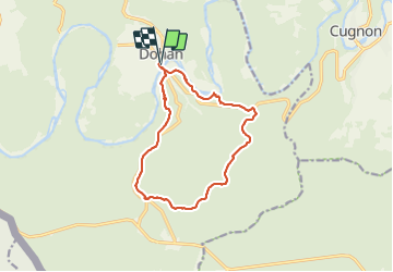
Trail Walking of 12.2 km to be discovered at Wallonia, Luxembourg, Bouillon. This trail is proposed by thomarche.
Description
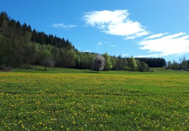
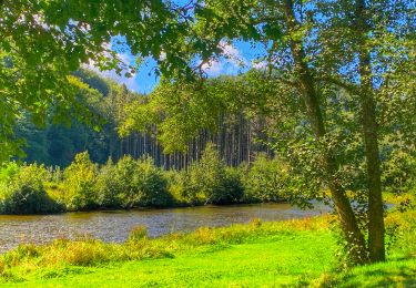
Belle boucle au sud de Dohan principalement e forêt. Points de vue sur la Semois: Roche de Dampiré et un second plus haut. Faites sous une pluie continue donc un peu raccourcie (cabane à pique nique au bord d’une petite route à pile 4km)
Positioning
Country:
Belgium
Region :
Wallonia
Department/Province :
Luxembourg
Municipality :
Bouillon
Location:
Unknown
Start:(Dec)
Start:(UTM)
654156 ; 5518034 (31U) N.
Comments
Trails nearby
![Trail Other activity Bertrix - BX08 - Photo](https://media.geolcdn.com/t/375/260/ext.jpg?maxdim=2&url=https%3A%2F%2Fstatic1.geolcdn.com%2Fsiteimages%2Fupload%2Ffiles%2F1545311037marcheuse_200dpi.jpg)
![Other activity Other activity](https://static1.geolcdn.com/sitytour/trail-icons/900.png)
BX08
Other activity
Very easy
(9)
Bertrix,
Wallonia,
Luxembourg,
Belgium
![](/images/other/stat-length.png)
7.3 km | 10 km-effort
2h 30min
![](https://static1.geolcdn.com/siteimages/upload/files/16400158638029165_repeat_loop_refresh_sync_direction_icon.png)
Yes
![Trail Walking Bouillon - GR16 SEMOIS 1 : Dohan - Photo](https://media.geolcdn.com/t/375/260/5a72d435-6e63-4e10-8243-a0a93e161c94.jpg&format=jpg&maxdim=2)
![Walking Walking](https://static1.geolcdn.com/sitytour/trail-icons/101.png)
GR16 SEMOIS 1 : Dohan
Walking
Easy
(1)
Bouillon,
Wallonia,
Luxembourg,
Belgium
![](/images/other/stat-length.png)
6.7 km | 8.3 km-effort
1h 19min
![](https://static1.geolcdn.com/siteimages/upload/files/16400158638029165_repeat_loop_refresh_sync_direction_icon.png)
Yes
![Trail Other activity Bertrix - BX18 - Photo](https://media.geolcdn.com/t/375/260/ext.jpg?maxdim=2&url=https%3A%2F%2Fstatic1.geolcdn.com%2Fsiteimages%2Fupload%2Ffiles%2F1545311037marcheuse_200dpi.jpg)
![Other activity Other activity](https://static1.geolcdn.com/sitytour/trail-icons/900.png)
BX18
Other activity
Medium
(3)
Bertrix,
Wallonia,
Luxembourg,
Belgium
![](/images/other/stat-length.png)
7.2 km | 10 km-effort
2h 20min
![](https://static1.geolcdn.com/siteimages/upload/files/16400158638029165_repeat_loop_refresh_sync_direction_icon.png)
Yes
![Trail Walking Bouillon - 2024-09-15_08h33m03_Les Hayons Bouillon - Photo](https://media.geolcdn.com/t/375/260/3874a8c0-e0c6-48f9-a0a0-20d74c421487.jpg&format=jpg&maxdim=2)
![Walking Walking](https://static1.geolcdn.com/sitytour/trail-icons/101.png)
2024-09-15_08h33m03_Les Hayons Bouillon
Walking
Difficult
Bouillon,
Wallonia,
Luxembourg,
Belgium
![](/images/other/stat-length.png)
10.1 km | 13.6 km-effort
3h 5min
![](https://static1.geolcdn.com/siteimages/upload/files/16400158638029165_repeat_loop_refresh_sync_direction_icon.png)
Yes
![Trail On foot Bouillon - Promenade de la Roche percée 47 - Photo](https://media.geolcdn.com/t/375/260/ext.jpg?maxdim=2&url=https%3A%2F%2Fpivotmedia.tourismewallonie.be%2FOTH-A0-006F-1M95%2FOTH-A0-006F-1M95.jpg)
![On foot On foot](https://static1.geolcdn.com/sitytour/trail-icons/100.png)
Promenade de la Roche percée 47
On foot
Easy
(1)
Bouillon,
Wallonia,
Luxembourg,
Belgium
![](/images/other/stat-length.png)
6.3 km | 8.7 km-effort
1h 58min
![](https://static1.geolcdn.com/siteimages/upload/files/16400158638029165_repeat_loop_refresh_sync_direction_icon.png)
Yes
![Trail On foot Bouillon - Promenade de Viaumont - Rivage de Marion 40 - Photo](https://media.geolcdn.com/t/375/260/ext.jpg?maxdim=2&url=https%3A%2F%2Fpivotmedia.tourismewallonie.be%2FOTH-A0-005O-332J%2FOTH-A0-005O-332J.jpg)
![On foot On foot](https://static1.geolcdn.com/sitytour/trail-icons/100.png)
Promenade de Viaumont - Rivage de Marion 40
On foot
Easy
(1)
Bouillon,
Wallonia,
Luxembourg,
Belgium
![](/images/other/stat-length.png)
5.5 km | 7.7 km-effort
1h 44min
![](https://static1.geolcdn.com/siteimages/upload/files/16400158638029165_repeat_loop_refresh_sync_direction_icon.png)
Yes
![Trail On foot Bouillon - Promenade gros chêne français et chêne des Mouches 21 - Photo](https://media.geolcdn.com/t/375/260/ext.jpg?maxdim=2&url=https%3A%2F%2Fpivotmedia.tourismewallonie.be%2FOTH-A0-005W-1OGV%2FOTH-A0-005W-1OGV.jpg)
![On foot On foot](https://static1.geolcdn.com/sitytour/trail-icons/100.png)
Promenade gros chêne français et chêne des Mouches 21
On foot
Easy
(1)
Bouillon,
Wallonia,
Luxembourg,
Belgium
![](/images/other/stat-length.png)
9.7 km | 13.3 km-effort
3h 1min
![](https://static1.geolcdn.com/siteimages/upload/files/16400158638029165_repeat_loop_refresh_sync_direction_icon.png)
Yes
![Trail On foot Bouillon - Promenade du Rocher Lecomte 42 - Photo](https://media.geolcdn.com/t/375/260/ext.jpg?maxdim=2&url=https%3A%2F%2Fpivotmedia.tourismewallonie.be%2FOTH-A0-005W-1VH6%2FOTH-A0-005W-1VH6.jpg)
![On foot On foot](https://static1.geolcdn.com/sitytour/trail-icons/100.png)
Promenade du Rocher Lecomte 42
On foot
Easy
(1)
Bouillon,
Wallonia,
Luxembourg,
Belgium
![](/images/other/stat-length.png)
4.8 km | 7 km-effort
1h 35min
![](https://static1.geolcdn.com/siteimages/upload/files/16400158638029165_repeat_loop_refresh_sync_direction_icon.png)
Yes
![Trail On foot Bouillon - Promenade de la Dampirée et de la Saurpire 43 - Photo](https://media.geolcdn.com/t/375/260/ext.jpg?maxdim=2&url=https%3A%2F%2Fpivotmedia.tourismewallonie.be%2FOTH-A0-005W-1T5L%2FOTH-A0-005W-1T5L.jpg)
![On foot On foot](https://static1.geolcdn.com/sitytour/trail-icons/100.png)
Promenade de la Dampirée et de la Saurpire 43
On foot
Easy
Bouillon,
Wallonia,
Luxembourg,
Belgium
![](/images/other/stat-length.png)
8.3 km | 11.3 km-effort
2h 34min
![](https://static1.geolcdn.com/siteimages/upload/files/16400158638029165_repeat_loop_refresh_sync_direction_icon.png)
Yes