![](/images/other/stat-length.png)
![Trail Mountain bike Espédaillac - T1 - Photo](https://media.geolcdn.com/t/1900/400/ext.pjpeg?maxdim=2&url=https%3A%2F%2Fstatic1.geolcdn.com%2Fsiteimages%2Fupload%2Ffiles%2F1524743154velo.jpg)
T1
sebcar
User
![Length](/images/other/stat-length.png)
Length
17.5 km
![Max alt](https://static1.geolcdn.com/siteimages/upload/files/1508320355ic_sort_altitude_max_24dp.png)
Max alt
367 m
![Uphill gradient](https://static1.geolcdn.com/siteimages/upload/files/1508320355ic_sort_den_pos_24dp.png)
Uphill gradient
239 m
![Km-Effort](/images/other/stat-length.png)
Km-Effort
21 km
![Min alt](https://static1.geolcdn.com/siteimages/upload/files/1508320355ic_sort_altitude_min_24dp.png)
Min alt
267 m
![Downhill gradient](https://static1.geolcdn.com/siteimages/upload/files/1508320355ic_sort_den_neg_24dp.png)
Downhill gradient
239 m
![Boucle](https://static1.geolcdn.com/siteimages/upload/files/16400158638029165_repeat_loop_refresh_sync_direction_icon.png)
Boucle
Yes
Creation date :
2021-10-29 18:06:02.103
Updated on :
2021-10-29 18:29:17.95
![Mountain bike](https://static1.geolcdn.com/sitytour/trail-icons/202.png)
1h26
Difficulty : Medium
![Scan this QR Code to open this trail in the SityTrail application](https://capi.geolives.com/qq0zvz2zws4bq2lad0pu/sitytour/trails/2986923/qr.png?size=200)
FREE GPS app for hiking
About
Trail Mountain bike of 17.5 km to be discovered at Occitania, Lot, Espédaillac. This trail is proposed by sebcar.
Description
Exepté les traversées de routes départementales, ce circuit en plein cœur du Parc Naturel Régional est très accessible pour les néophytes. Murets, chemins caillouteux et pelouses séches constituent les principaux attraits.
Positioning
Country:
France
Region :
Occitania
Department/Province :
Lot
Municipality :
Espédaillac
Location:
Unknown
Start:(Dec)
Start:(UTM)
402655 ; 4943214 (31T) N.
Comments
Trails nearby
![Trail Walking Espédaillac - Grezes Espedaillac Mas de l’artillou - Photo](https://media.geolcdn.com/t/375/260/2da8ae1c-b24d-46b1-b4e8-35e756a3da14.jpg&format=jpg&maxdim=2)
![Walking Walking](https://static1.geolcdn.com/sitytour/trail-icons/101.png)
Grezes Espedaillac Mas de l’artillou
Walking
Very easy
Espédaillac,
Occitania,
Lot,
France
![](/images/other/stat-length.png)
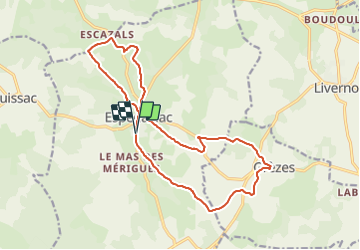
14.5 km | 17.1 km-effort
3h 22min
![](https://static1.geolcdn.com/siteimages/upload/files/16400158638029165_repeat_loop_refresh_sync_direction_icon.png)
Yes
![Trail Walking Quissac - Quissac espedaillac bis - Photo](https://media.geolcdn.com/t/375/260/886db38d-0589-4e74-a92d-9ccc1fca4f0f.jpg&format=jpg&maxdim=2)
![Walking Walking](https://static1.geolcdn.com/sitytour/trail-icons/101.png)
Quissac espedaillac bis
Walking
Very easy
Quissac,
Occitania,
Lot,
France
![](/images/other/stat-length.png)
14 km | 17.2 km-effort
3h 18min
![](https://static1.geolcdn.com/siteimages/upload/files/16400158638029165_repeat_loop_refresh_sync_direction_icon.png)
Yes
![Trail On foot Espédaillac - Tour d'Espédaillac - Photo](https://media.geolcdn.com/t/375/260/21e1216d-44a1-4225-a087-7e5fa7bc3223.jpeg&format=jpg&maxdim=2)
![On foot On foot](https://static1.geolcdn.com/sitytour/trail-icons/100.png)
![Trail Walking Espédaillac - Espedaillac 3 - Photo](https://media.geolcdn.com/t/375/260/f3971ed4-4284-4a04-a6f3-c7a23471f5c0.jpg&format=jpg&maxdim=2)
![Walking Walking](https://static1.geolcdn.com/sitytour/trail-icons/101.png)
Espedaillac 3
Walking
Difficult
Espédaillac,
Occitania,
Lot,
France
![](/images/other/stat-length.png)
10.3 km | 12.3 km-effort
2h 47min
![](https://static1.geolcdn.com/siteimages/upload/files/16400158638029165_repeat_loop_refresh_sync_direction_icon.png)
Yes
![Trail Walking Espédaillac - Espedaillac quissac - Photo](https://media.geolcdn.com/t/375/260/93027083-a00b-4452-a788-a1384747456a.jpg&format=jpg&maxdim=2)
![Walking Walking](https://static1.geolcdn.com/sitytour/trail-icons/101.png)
Espedaillac quissac
Walking
Very easy
Espédaillac,
Occitania,
Lot,
France
![](/images/other/stat-length.png)
13.1 km | 16.1 km-effort
2h 49min
![](https://static1.geolcdn.com/siteimages/upload/files/16400158638029165_repeat_loop_refresh_sync_direction_icon.png)
Yes
![Trail Walking Grèzes - grezesg - Photo](https://media.geolcdn.com/t/375/260/56c52572-6e25-40c3-80ec-6c0eecd4e761.jpg&format=jpg&maxdim=2)
![Walking Walking](https://static1.geolcdn.com/sitytour/trail-icons/101.png)
![Trail Walking Grèzes - Grezes - Photo](https://media.geolcdn.com/t/375/260/ext.jpg?maxdim=2&url=https%3A%2F%2Fservices.sitytrail.com%2FGeolivesWS%2FDownloadMedia.ashx%3FTrailID%3D877574%26Media%3Dfix__20171219153456.jpg)
![Walking Walking](https://static1.geolcdn.com/sitytour/trail-icons/101.png)
![Trail Walking Espédaillac - Espedaillac - Photo](https://media.geolcdn.com/t/375/260/ext.jpg?maxdim=2&url=https%3A%2F%2Fstatic1.geolcdn.com%2Fsiteimages%2Fupload%2Ffiles%2F1553511878bg_sport_marche.png)
![Walking Walking](https://static1.geolcdn.com/sitytour/trail-icons/101.png)
![Trail Walking Espédaillac - Espedaillac - Photo](https://media.geolcdn.com/t/375/260/ext.jpg?maxdim=2&url=https%3A%2F%2Fstatic1.geolcdn.com%2Fsiteimages%2Fupload%2Ffiles%2F1553511878bg_sport_marche.png)
![Walking Walking](https://static1.geolcdn.com/sitytour/trail-icons/101.png)
Espedaillac
Walking
Very difficult
Espédaillac,
Occitania,
Lot,
France
![](/images/other/stat-length.png)
22 km | 28 km-effort
1h 9min
![](https://static1.geolcdn.com/siteimages/upload/files/16400158638029165_repeat_loop_refresh_sync_direction_icon.png)
No