


 - Balade_VTT_30kms - Photo 21")
 - Balade_VTT_30kms - Photo 22")
 - Balade_VTT_30kms - Photo 23")
 - Balade_VTT_30kms - Photo 24")
 - Balade_VTT_30kms - Photo 25")
 - Balade_VTT_30kms - Photo 26")
 - Balade_VTT_30kms - Photo 27")
 - Balade_VTT_30kms - Photo 28")
 - Balade_VTT_30kms - Photo 29")
 - Balade_VTT_30kms - Photo 30")
 - Balade_VTT_30kms - Photo 31")
 - Balade_VTT_30kms - Photo 32")
 - Balade_VTT_30kms - Photo 33")
 - Balade_VTT_30kms - Photo 34")
 - Balade_VTT_30kms - Photo 35")
 - Balade_VTT_30kms - Photo 36")
 - Balade_VTT_30kms - Photo 37")
 - Balade_VTT_30kms - Photo 38")
 - Balade_VTT_30kms - Photo 39")
 - Balade_VTT_30kms - Photo 40")
 - Balade_VTT_30kms - Photo 41")
 - Balade_VTT_30kms - Photo 42")
 - Balade_VTT_30kms - Photo 43")
 - Balade_VTT_30kms - Photo 44")
 - Balade_VTT_30kms - Photo 45")
 - Balade_VTT_30kms - Photo 46")
 - Balade_VTT_30kms - Photo 47")
 - Balade_VTT_30kms - Photo 48")
 - Balade_VTT_30kms - Photo 49")
 - Balade_VTT_30kms - Photo 50")
 - Balade_VTT_30kms - Photo 51")
 - Balade_VTT_30kms - Photo 52")
 - Balade_VTT_30kms - Photo 53")
 - Balade_VTT_30kms - Photo 54")
 - Balade_VTT_30kms - Photo 55")
 - Balade_VTT_30kms - Photo 56")
 - Balade_VTT_30kms - Photo 57")
 - Balade_VTT_30kms - Photo 58")
 - Balade_VTT_30kms - Photo 59")
 - Balade_VTT_30kms - Photo 60")
 - Balade_VTT_30kms - Photo 61")
 - Balade_VTT_30kms - Photo 62")
 - Balade_VTT_30kms - Photo 63")
 - Balade_VTT_30kms - Photo 64")
 - Balade_VTT_30kms - Photo 65")
 - Balade_VTT_30kms - Photo 66")
 - Balade_VTT_30kms - Photo 67")
 - Balade_VTT_30kms - Photo 68")
 - Balade_VTT_30kms - Photo 69")
 - Balade_VTT_30kms - Photo 70")
 - Balade_VTT_30kms - Photo 71")
 - Balade_VTT_30kms - Photo 72")
 - Balade_VTT_30kms - Photo 73")
 - Balade_VTT_30kms - Photo 74")
 - Balade_VTT_30kms - Photo 75")
 - Balade_VTT_30kms - Photo 76")
 - Balade_VTT_30kms - Photo 77")
 - Balade_VTT_30kms - Photo 78")
 - Balade_VTT_30kms - Photo 79")
 - Balade_VTT_30kms - Photo 80")
 - Balade_VTT_30kms - Photo 81")
 - Balade_VTT_30kms - Photo 82")
 - Balade_VTT_30kms - Photo 83")
 - Balade_VTT_30kms - Photo 84")
 - Balade_VTT_30kms - Photo 85")
 - Balade_VTT_30kms - Photo 86")
 - Balade_VTT_30kms - Photo 87")
 - Balade_VTT_30kms - Photo 88")
 - Balade_VTT_30kms - Photo 89")
 - Balade_VTT_30kms - Photo 90")
 - Balade_VTT_30kms - Photo 91")
 - Balade_VTT_30kms - Photo 92")
 - Balade_VTT_30kms - Photo 93")
 - Balade_VTT_30kms - Photo 94")
 - Balade_VTT_30kms - Photo 95")
 - Balade_VTT_30kms - Photo 96")
 - Balade_VTT_30kms - Photo 97")
 - Balade_VTT_30kms - Photo 98")
 - Balade_VTT_30kms - Photo 99")
 - Balade_VTT_30kms - Photo 100")
 - Balade_VTT_30kms - Photo 101")
 - Balade_VTT_30kms - Photo 102")
 - Balade_VTT_30kms - Photo 103")
 - Balade_VTT_30kms - Photo 104")
 - Balade_VTT_30kms - Photo 105")
 - Balade_VTT_30kms - Photo 106")
 - Balade_VTT_30kms - Photo 107")
 - Balade_VTT_30kms - Photo 108")


29 km | 35 km-effort

User


FREE GPS app for hiking
 SityTrail
IGN / Geographical institutes
SityTrail World
The world is yours!
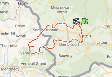
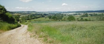
Trail Mountain bike of 30 km to be discovered at Wallonia, Luxembourg, Virton. This trail is proposed by Pascal L.
Départ/Retour: Virton (Grange au Bois)
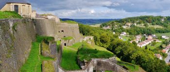
Endroits de passage : Houdrigny, Sommethonne, Thonne-la-Long, panorama avant d'arriver à la Ferme de Saint-Valéry (vue au loin d'Avioth), Verneuil-Petit (vue au loin de la citadelle de Montmédy), Croix Sainte Reine, Couvreux, Dampicourt.
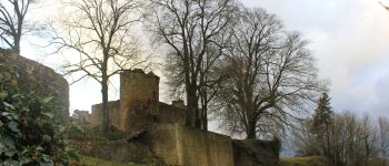
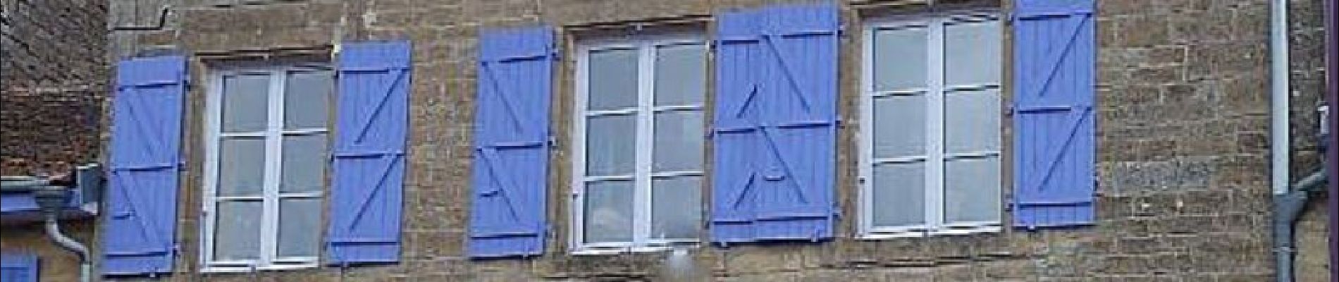
Verneuil-Petit est une commune française rurale située dans le département de la Meuse en région Grand Est (Lorraine gaumaise). On y trouve une jolie petite Mairie, l'église Saint Martin du XIIe siècle, et un lavoir de 1769 (un des plus anciens du Pays de Montmédy).
Vidéos (): TODO
1) (Lat: 49.657 , Lng: 5.562)
2) ...
3) ...
Ref.
- http://www.tourisme-montmedy.com/village_verneuil-petit.php
- https://rouvroy.be/presentation/52/le-village-de-couvreux
(2021.10.23)
 - Balade_VTT_30kms - Photo 1")
 - Balade_VTT_30kms - Photo 2")
 - Balade_VTT_30kms - Photo 3")
 - Balade_VTT_30kms - Photo 4")
 - Balade_VTT_30kms - Photo 5")
 - Balade_VTT_30kms - Photo 6")
 - Balade_VTT_30kms - Photo 7")
 - Balade_VTT_30kms - Photo 8")
 - Balade_VTT_30kms - Photo 9")
 - Balade_VTT_30kms - Photo 10")
 - Balade_VTT_30kms - Photo 11")
 - Balade_VTT_30kms - Photo 12")
 - Balade_VTT_30kms - Photo 13")
 - Balade_VTT_30kms - Photo 14")
 - Balade_VTT_30kms - Photo 15")
 - Balade_VTT_30kms - Photo 16")
 - Balade_VTT_30kms - Photo 17")
 - Balade_VTT_30kms - Photo 18")
 - Balade_VTT_30kms - Photo 19")
 - Balade_VTT_30kms - Photo 20")
108 photos in total. Please click on a photo to see them all in the gallery.

Walking

Mountain bike

On foot

Walking

Walking

Mountain bike

Mountain bike

Mountain bike
Mountain bike