![](/images/other/stat-length.png)
![Trail Walking Fontaines-d'Ozillac - La Comté à Fontaine d'Ozillac en vallée de la Seugne - Photo](https://media.geolcdn.com/t/1900/400/ext.pjpeg?maxdim=2&url=https%3A%2F%2Fstatic1.geolcdn.com%2Fsiteimages%2Fupload%2Ffiles%2F1553511878bg_sport_marche.png)
La Comté à Fontaine d'Ozillac en vallée de la Seugne
neoroll44
User
![Length](/images/other/stat-length.png)
![Max alt](https://static1.geolcdn.com/siteimages/upload/files/1508320355ic_sort_altitude_max_24dp.png)
![Uphill gradient](https://static1.geolcdn.com/siteimages/upload/files/1508320355ic_sort_den_pos_24dp.png)
![Km-Effort](/images/other/stat-length.png)
![Min alt](https://static1.geolcdn.com/siteimages/upload/files/1508320355ic_sort_altitude_min_24dp.png)
![Downhill gradient](https://static1.geolcdn.com/siteimages/upload/files/1508320355ic_sort_den_neg_24dp.png)
![Boucle](https://static1.geolcdn.com/siteimages/upload/files/16400158638029165_repeat_loop_refresh_sync_direction_icon.png)
![Walking](https://static1.geolcdn.com/sitytour/trail-icons/101.png)
2h20
Difficulty : Medium
![Scan this QR Code to open this trail in the SityTrail application](https://capi.geolives.com/qq0zvz2zws4bq2lad0pu/sitytour/trails/2976877/qr.png?size=200)
FREE GPS app for hiking
About
Trail Walking of 9 km to be discovered at New Aquitaine, Charente-Maritime, Fontaines-d'Ozillac. This trail is proposed by neoroll44.
Description
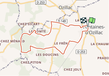
(D/A) Partir vers la gauche pour passer devant l'école. A l'intersection, prendre à droite, direction Villexavier, puis à gauche juste avant le pont de la voie ferrée : le chemin d'accès gravillonné se poursuit par un chemin herbeux le long de la voie. Parcourir environ 500m jusqu'à la route.
(1) Prendre à droite, traverser la voie ferrée et aller jusqu'au lieu-dit chez Savary. Dans le hameau, prendre à gauche et emprunter un chemin blanc qui rejoint le bois. A la lisière du bois, suivre le chemin qui part à droite et longe le pré des chevaux jusqu'à la petite route départementale D149. Traverser avec prudence pour prendre le chemin en face menant à un sous-bois de châtaigniers.
(2) A la sortie du sous-bois, traverser une petite route pour continuer en face et suivre un chemin à travers champs. Le sentier s'avance en sous-bois et longe la lisière vers la gauche avant de bifurquer à droite et de plonger dans la forêt.
(3) Au bout de 350m dans cette direction, vous ressortez du couvert forestier pour regagner quelques mètres plus loin un large sentier qui part à droite le long du ruisseau La Cendronne et replonge en sous-bois. Après 700m environ, le chemin s'incurve vers la droite sous un tunnel arbustif qui s'ouvre de nouveau sur un large chemin. Suivre ce chemin quelques mètres encore.
(4) Le chemin tourne à gauche et quitte le sous-bois pour remonter vers la Comté. A la sortie du chemin en arrivant sur la route d'accès à la ferme qui se tient en face, ne pas remonter vers le lieu-dit de la Comté, mais prendre à droite pour passer derrière la ferme. Un chemin redescend jusqu'à une petite route que l'on suivra à gauche jusqu'au hameau de chez Pagnolet.
(5) A l'intersection avec la D154, continuer en face vers chez Maurin, puis à l'intersection suivante prendre à droite vers le château d'eau. Continuer dans cette direction pour traverser la D149 puis prendre à gauche et rejoindre la Chapelle.
(6) A la petite chapelle, prendre la route à droite puis le chemin qui passe sous la voie ferrée à gauche. Ressortir sur la route et tourner à droite pour regagner le point de départ (D/A).
Points of interest
Positioning
Comments
Trails nearby
![Trail Walking Champagnac - roro - Photo](https://media.geolcdn.com/t/375/260/ext.jpg?maxdim=2&url=https%3A%2F%2Fstatic1.geolcdn.com%2Fsiteimages%2Fupload%2Ffiles%2F1553511878bg_sport_marche.png)
![Walking Walking](https://static1.geolcdn.com/sitytour/trail-icons/101.png)
Walking
![](/images/other/stat-length.png)
![](https://static1.geolcdn.com/siteimages/upload/files/16400158638029165_repeat_loop_refresh_sync_direction_icon.png)
![Trail Walking Léoville - Léoville Les moulins - Photo](https://media.geolcdn.com/t/375/260/ext.jpg?maxdim=2&url=https%3A%2F%2Fstatic1.geolcdn.com%2Fsiteimages%2Fupload%2Ffiles%2F1553511878bg_sport_marche.png)
![Walking Walking](https://static1.geolcdn.com/sitytour/trail-icons/101.png)
Walking
![](/images/other/stat-length.png)
![](https://static1.geolcdn.com/siteimages/upload/files/16400158638029165_repeat_loop_refresh_sync_direction_icon.png)
![Trail Walking Léoville - Léoville par St Maurice de Laurencanne - Photo](https://media.geolcdn.com/t/375/260/ext.jpg?maxdim=2&url=https%3A%2F%2Fstatic1.geolcdn.com%2Fsiteimages%2Fupload%2Ffiles%2F1553511878bg_sport_marche.png)
![Walking Walking](https://static1.geolcdn.com/sitytour/trail-icons/101.png)
Walking
![](/images/other/stat-length.png)
![](https://static1.geolcdn.com/siteimages/upload/files/16400158638029165_repeat_loop_refresh_sync_direction_icon.png)
![Trail Walking Villexavier - St Simon de Bordes - Photo](https://media.geolcdn.com/t/375/260/ext.jpg?maxdim=2&url=https%3A%2F%2Fstatic1.geolcdn.com%2Fsiteimages%2Fupload%2Ffiles%2F1553511878bg_sport_marche.png)
![Walking Walking](https://static1.geolcdn.com/sitytour/trail-icons/101.png)
Walking
![](/images/other/stat-length.png)
![](https://static1.geolcdn.com/siteimages/upload/files/16400158638029165_repeat_loop_refresh_sync_direction_icon.png)
![Trail Walking Vibrac - Vibrac - Photo](https://media.geolcdn.com/t/375/260/ext.jpg?maxdim=2&url=https%3A%2F%2Fstatic1.geolcdn.com%2Fsiteimages%2Fupload%2Ffiles%2F1553511878bg_sport_marche.png)
![Walking Walking](https://static1.geolcdn.com/sitytour/trail-icons/101.png)
Walking
![](/images/other/stat-length.png)
![](https://static1.geolcdn.com/siteimages/upload/files/16400158638029165_repeat_loop_refresh_sync_direction_icon.png)
![Trail Walking Saint-Germain-de-Vibrac - Saint Germain de Vibrac 12 km - Photo](https://media.geolcdn.com/t/375/260/ext.jpg?maxdim=2&url=https%3A%2F%2Fstatic1.geolcdn.com%2Fsiteimages%2Fupload%2Ffiles%2F1553511878bg_sport_marche.png)
![Walking Walking](https://static1.geolcdn.com/sitytour/trail-icons/101.png)
Walking
![](/images/other/stat-length.png)
![](https://static1.geolcdn.com/siteimages/upload/files/16400158638029165_repeat_loop_refresh_sync_direction_icon.png)
![Trail Walking Fontaines-d'Ozillac - Fontaines d'Ozillac 10,5 km - Photo](https://media.geolcdn.com/t/375/260/ext.jpg?maxdim=2&url=https%3A%2F%2Fstatic1.geolcdn.com%2Fsiteimages%2Fupload%2Ffiles%2F1553511878bg_sport_marche.png)
![Walking Walking](https://static1.geolcdn.com/sitytour/trail-icons/101.png)
Walking
![](/images/other/stat-length.png)
![](https://static1.geolcdn.com/siteimages/upload/files/16400158638029165_repeat_loop_refresh_sync_direction_icon.png)
![Trail On foot Saint-Germain-de-Vibrac - Saint Germain de Vibrac 10km - Photo](https://media.geolcdn.com/t/375/260/ext.jpg?maxdim=2&url=https%3A%2F%2Fstatic1.geolcdn.com%2Fsiteimages%2Fupload%2Ffiles%2F1545311037marcheuse_200dpi.jpg)
![On foot On foot](https://static1.geolcdn.com/sitytour/trail-icons/100.png)
On foot
![](/images/other/stat-length.png)
![](https://static1.geolcdn.com/siteimages/upload/files/16400158638029165_repeat_loop_refresh_sync_direction_icon.png)
![Trail Walking Villexavier - Villexavier 10km - Photo](https://media.geolcdn.com/t/375/260/ext.jpg?maxdim=2&url=https%3A%2F%2Fstatic1.geolcdn.com%2Fsiteimages%2Fupload%2Ffiles%2F1553511878bg_sport_marche.png)
![Walking Walking](https://static1.geolcdn.com/sitytour/trail-icons/101.png)
Walking
![](/images/other/stat-length.png)
![](https://static1.geolcdn.com/siteimages/upload/files/16400158638029165_repeat_loop_refresh_sync_direction_icon.png)