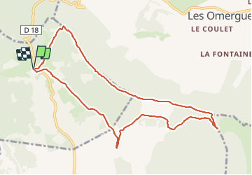
Trail Walking Barret-de-Lioure - du col du negron à la pyramide du moine  - Photo

du col du negron à la pyramide du moine

 Jemasa9
Jemasa9

User

© OpenStreetMap contributors
Length
Length
10.6 km
Max alt
Max alt
1404 m
Uphill gradient
Uphill gradient
341 m
Km-Effort
Km-Effort  
15.1 km
Min alt
Min alt
1196 m
Downhill gradient
Downhill gradient
343 m
Boucle
Boucle
Yes
Creation date :
2021-10-19 07:55:47.772
Updated on :
2021-10-19 18:28:27.431

(0 Reviews)

Walking
Walking
4h03
Difficulty : Easy

Scan this QR Code to open this trail in the SityTrail application

FREE GPS app for hiking

Logo SityTrail SityTrail

IGN / Geographical institutes

Download SityTrail from the App Store Download SityTrail from Google Play

Logo SityTrail SityTrail World

The world is yours!

Download SityTrail from the App Store Download SityTrail from Google Play Download SityTrail on Huawei AppGallery

About

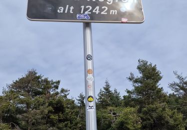
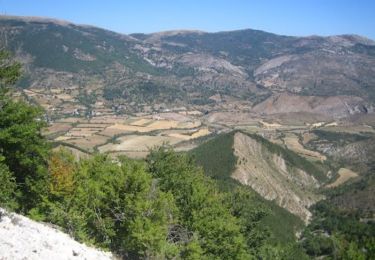
Trail Walking of 10.6 km to be discovered at Auvergne-Rhône-Alpes, Drôme, Barret-de-Lioure. This trail is proposed by Jemasa9.

Description

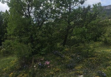
j ai flâne.  4h suffisent.  au bout   de la forêt de chamouse les sentiers sont pas très visibles

Elevation profile

Photos

Positioning

Country:
France
Region :
Auvergne-Rhône-Alpes
Department/Province :
Drôme
Municipality :
Barret-de-Lioure
Location:
Unknown
Start:(UTM)
704668 ; 4893099 (31T) N.

Trails nearby

Trail Walking Séderon - Du Sommet du Négron au Sommet de Larran - Photo
Walking
Marco05

Walking

Medium
Séderon, Auvergne-Rhône-Alpes, Drôme, France
15.6 km | 22 km-effort
5h 4min
No
Trail Walking Les Omergues - Saint André de villeseche. la pyramide du moine  - Photo
Walking
Roger

Walking

Medium
Les Omergues, Provence-Alpes-Côte d'Azur, Alpes-de-Haute-Provence, France
10 km | 13.6 km-effort
4h 0min
Yes
Trail Walking Séderon - SEDERON Cretes de Serrieres o n - Photo
Walking
RobinMicheline

Walking

Difficult
Séderon, Auvergne-Rhône-Alpes, Drôme, France
14.6 km | 22 km-effort
5h 31min
Yes
Trail Walking Séderon - Les Bergiès via Séderon - Photo
Walking
PapouBertrand

Walking

Very difficult
Séderon, Auvergne-Rhône-Alpes, Drôme, France
16.7 km | 25 km-effort
5h 45min
Yes
Trail Walking Séderon - Autour du col du Negron - Photo
Walking
PITOUSSAINT

Walking

Easy
Séderon, Auvergne-Rhône-Alpes, Drôme, France
6.6 km | 10 km-effort
3h 27min
Yes
Trail Walking Séderon - Sederon - col du Negron - Photo
Walking
lviallet

Walking

Very difficult
Séderon, Auvergne-Rhône-Alpes, Drôme, France
14.9 km | 23 km-effort
4h 20min
Yes
Trail Trail Les Omergues - t16315-MNT - Photo
Trail
phd04

Trail

Very difficult
Les Omergues, Provence-Alpes-Côte d'Azur, Alpes-de-Haute-Provence, France
16.8 km | 27 km-effort
2h 30min
Yes
Trail Walking Les Omergues - les Omergues à Montfroc - Photo
Walking
PITOUSSAINT

Walking

Easy
Les Omergues, Provence-Alpes-Côte d'Azur, Alpes-de-Haute-Provence, France
84 km | 105 km-effort
6h 38min
No
Trail Walking Ferrassières - du col de l'homme mort à la cabane de Cyprien - Photo
Walking
PITOUSSAINT

Walking

Easy
Ferrassières, Auvergne-Rhône-Alpes, Drôme, France
8.2 km | 13.1 km-effort
3h 52min
Yes


Close
My subscriptions