![](/images/other/stat-length.png)
![Trail On foot Saint-Setiers - GR440 jour 7 leie de bivouac à Meymac - Photo](https://media.geolcdn.com/t/1900/400/ext.pjpeg?maxdim=2&url=https%3A%2F%2Fstatic1.geolcdn.com%2Fsiteimages%2Fupload%2Ffiles%2F1545311037marcheuse_200dpi.jpg)
GR440 jour 7 leie de bivouac à Meymac
MathieuBourgois
User
![Length](/images/other/stat-length.png)
Length
13.6 km
![Max alt](https://static1.geolcdn.com/siteimages/upload/files/1508320355ic_sort_altitude_max_24dp.png)
Max alt
955 m
![Uphill gradient](https://static1.geolcdn.com/siteimages/upload/files/1508320355ic_sort_den_pos_24dp.png)
Uphill gradient
411 m
![Km-Effort](/images/other/stat-length.png)
Km-Effort
18.9 km
![Min alt](https://static1.geolcdn.com/siteimages/upload/files/1508320355ic_sort_altitude_min_24dp.png)
Min alt
723 m
![Downhill gradient](https://static1.geolcdn.com/siteimages/upload/files/1508320355ic_sort_den_neg_24dp.png)
Downhill gradient
364 m
![Boucle](https://static1.geolcdn.com/siteimages/upload/files/16400158638029165_repeat_loop_refresh_sync_direction_icon.png)
Boucle
No
Creation date :
2021-10-14 09:50:55.131
Updated on :
2021-10-14 10:31:38.385
![On foot](https://static1.geolcdn.com/sitytour/trail-icons/100.png)
35m
Difficulty : Easy
![Scan this QR Code to open this trail in the SityTrail application](https://capi.geolives.com/qq0zvz2zws4bq2lad0pu/sitytour/trails/2969591/qr.png?size=200)
FREE GPS app for hiking
About
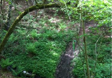
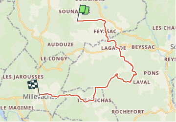
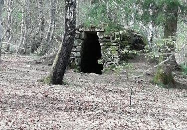
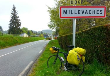
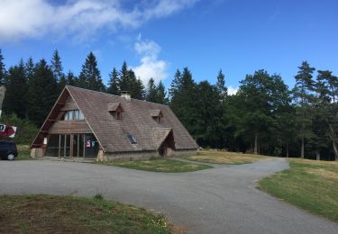
Trail On foot of 13.6 km to be discovered at New Aquitaine, Corrèze, Saint-Setiers. This trail is proposed by MathieuBourgois.
Description
-Altitude max 955m
-Feyssac 2km et 10D
-Tafalechas 10km et 260D
-Millevaches 14km et 410D
-Taxi jusqu'à Meymac (13km)
-Nuit à Meymac
Positioning
Country:
France
Region :
New Aquitaine
Department/Province :
Corrèze
Municipality :
Saint-Setiers
Location:
Unknown
Start:(Dec)
Start:(UTM)
431576 ; 5058821 (31T) N.
Comments
Trails nearby
![Trail Walking Peyrelevade - Fred puy d auroc - Photo](https://media.geolcdn.com/t/375/260/a72adf5e-96ec-42bf-8879-b2bb5d44a472.jpg&format=jpg&maxdim=2)
![Walking Walking](https://static1.geolcdn.com/sitytour/trail-icons/101.png)
Fred puy d auroc
Walking
Difficult
Peyrelevade,
New Aquitaine,
Corrèze,
France
![](/images/other/stat-length.png)
9.9 km | 13.1 km-effort
2h 46min
![](https://static1.geolcdn.com/siteimages/upload/files/16400158638029165_repeat_loop_refresh_sync_direction_icon.png)
Yes
![Trail Walking Saint-Setiers - Fred BC st setiers - Photo](https://media.geolcdn.com/t/375/260/8735683e-9462-4489-9aac-063e200fc93a.jpg&format=jpg&maxdim=2)
![Walking Walking](https://static1.geolcdn.com/sitytour/trail-icons/101.png)
Fred BC st setiers
Walking
Medium
Saint-Setiers,
New Aquitaine,
Corrèze,
France
![](/images/other/stat-length.png)
7.8 km | 10.7 km-effort
2h 39min
![](https://static1.geolcdn.com/siteimages/upload/files/16400158638029165_repeat_loop_refresh_sync_direction_icon.png)
Yes
![Trail On foot Millevaches - Sentier du puy des Pouges - Photo](https://media.geolcdn.com/t/375/260/6fd9e205-7ee1-47c1-890a-3e120b798d14.jpeg&format=jpg&maxdim=2)
![On foot On foot](https://static1.geolcdn.com/sitytour/trail-icons/100.png)
Sentier du puy des Pouges
On foot
Easy
Millevaches,
New Aquitaine,
Corrèze,
France
![](/images/other/stat-length.png)
5 km | 6.1 km-effort
1h 23min
![](https://static1.geolcdn.com/siteimages/upload/files/16400158638029165_repeat_loop_refresh_sync_direction_icon.png)
No
![On foot On foot](https://static1.geolcdn.com/sitytour/trail-icons/100.png)
Rando 8km autour de Vieillemaison
On foot
Easy
Saint-Setiers,
New Aquitaine,
Corrèze,
France
![](/images/other/stat-length.png)
10.9 km | 13.8 km-effort
2h 30min
![](https://static1.geolcdn.com/siteimages/upload/files/16400158638029165_repeat_loop_refresh_sync_direction_icon.png)
Yes
![Trail Walking Millevaches - mille ache - Photo](https://media.geolcdn.com/t/375/260/ext.jpg?maxdim=2&url=https%3A%2F%2Fstatic1.geolcdn.com%2Fsiteimages%2Fupload%2Ffiles%2F1553511878bg_sport_marche.png)
![Walking Walking](https://static1.geolcdn.com/sitytour/trail-icons/101.png)
mille ache
Walking
Very easy
Millevaches,
New Aquitaine,
Corrèze,
France
![](/images/other/stat-length.png)
5.9 km | 7.2 km-effort
2h 15min
![](https://static1.geolcdn.com/siteimages/upload/files/16400158638029165_repeat_loop_refresh_sync_direction_icon.png)
Yes
![Trail Walking Millevaches - Millevaches tourbières - Photo](https://media.geolcdn.com/t/375/260/ext.jpg?maxdim=2&url=https%3A%2F%2Fstatic1.geolcdn.com%2Fsiteimages%2Fupload%2Ffiles%2F1553511878bg_sport_marche.png)
![Walking Walking](https://static1.geolcdn.com/sitytour/trail-icons/101.png)
Millevaches tourbières
Walking
Medium
(1)
Millevaches,
New Aquitaine,
Corrèze,
France
![](/images/other/stat-length.png)
19.8 km | 25 km-effort
5h 2min
![](https://static1.geolcdn.com/siteimages/upload/files/16400158638029165_repeat_loop_refresh_sync_direction_icon.png)
Yes
![Trail Walking Saint-Setiers - Etape 5 Bis / Saint-Setiers à Milevaches - Photo](https://media.geolcdn.com/t/375/260/ext.jpg?maxdim=2&url=https%3A%2F%2Fstatic1.geolcdn.com%2Fsiteimages%2Fupload%2Ffiles%2F1553511878bg_sport_marche.png)
![Walking Walking](https://static1.geolcdn.com/sitytour/trail-icons/101.png)
Etape 5 Bis / Saint-Setiers à Milevaches
Walking
Very difficult
Saint-Setiers,
New Aquitaine,
Corrèze,
France
![](/images/other/stat-length.png)
21 km | 28 km-effort
6h 18min
![](https://static1.geolcdn.com/siteimages/upload/files/16400158638029165_repeat_loop_refresh_sync_direction_icon.png)
No
![Trail Walking Saint-Setiers - Saint-Sétiers à Sornac / Etape 5 bis - Photo](https://media.geolcdn.com/t/375/260/ext.jpg?maxdim=2&url=https%3A%2F%2Fstatic1.geolcdn.com%2Fsiteimages%2Fupload%2Ffiles%2F1553511878bg_sport_marche.png)
![Walking Walking](https://static1.geolcdn.com/sitytour/trail-icons/101.png)
Saint-Sétiers à Sornac / Etape 5 bis
Walking
Very difficult
Saint-Setiers,
New Aquitaine,
Corrèze,
France
![](/images/other/stat-length.png)
28 km | 36 km-effort
8h 5min
![](https://static1.geolcdn.com/siteimages/upload/files/16400158638029165_repeat_loop_refresh_sync_direction_icon.png)
No