![](/images/other/stat-length.png)
![Trail On foot Nedde - GR440, jour 5 : Lieu de bivouac à lieu de bivouac - Photo](https://media.geolcdn.com/t/1900/400/ext.pjpeg?maxdim=2&url=https%3A%2F%2Fstatic1.geolcdn.com%2Fsiteimages%2Fupload%2Ffiles%2F1545311037marcheuse_200dpi.jpg)
GR440, jour 5 : Lieu de bivouac à lieu de bivouac
MathieuBourgois
User
![Length](/images/other/stat-length.png)
Length
26 km
![Max alt](https://static1.geolcdn.com/siteimages/upload/files/1508320355ic_sort_altitude_max_24dp.png)
Max alt
783 m
![Uphill gradient](https://static1.geolcdn.com/siteimages/upload/files/1508320355ic_sort_den_pos_24dp.png)
Uphill gradient
601 m
![Km-Effort](/images/other/stat-length.png)
Km-Effort
33 km
![Min alt](https://static1.geolcdn.com/siteimages/upload/files/1508320355ic_sort_altitude_min_24dp.png)
Min alt
522 m
![Downhill gradient](https://static1.geolcdn.com/siteimages/upload/files/1508320355ic_sort_den_neg_24dp.png)
Downhill gradient
370 m
![Boucle](https://static1.geolcdn.com/siteimages/upload/files/16400158638029165_repeat_loop_refresh_sync_direction_icon.png)
Boucle
No
Creation date :
2021-10-14 09:32:21.146
Updated on :
2021-10-14 09:37:45.836
![On foot](https://static1.geolcdn.com/sitytour/trail-icons/100.png)
15m
Difficulty : Easy
![Scan this QR Code to open this trail in the SityTrail application](https://capi.geolives.com/qq0zvz2zws4bq2lad0pu/sitytour/trails/2969552/qr.png?size=200)
FREE GPS app for hiking
About
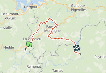
Trail On foot of 26 km to be discovered at New Aquitaine, Haute-Vienne, Nedde. This trail is proposed by MathieuBourgois.
Description
Altitude max 783m
-Les Farguettes 1km 30D
-La Villedieu 3.7km et 88D
-Plazanet 10km et 290D
-Faux-la-Montagne 14km et 365D
-Le Chammet 22km et 525D
-Lieu de bivouac sommet herbeux 26km et 600D
Positioning
Country:
France
Region :
New Aquitaine
Department/Province :
Haute-Vienne
Municipality :
Nedde
Location:
Unknown
Start:(Dec)
Start:(UTM)
412117 ; 5062782 (31T) N.
Comments
Trails nearby
![Trail Walking Nedde - La forêt de Chaux - Photo](https://media.geolcdn.com/t/375/260/7315d454-b9d9-4103-9fbb-6bac6a87eaaf.jpg&format=jpg&maxdim=2)
![Walking Walking](https://static1.geolcdn.com/sitytour/trail-icons/101.png)
La forêt de Chaux
Walking
Easy
Nedde,
New Aquitaine,
Haute-Vienne,
France
![](/images/other/stat-length.png)
12.8 km | 17.2 km-effort
5h 8min
![](https://static1.geolcdn.com/siteimages/upload/files/16400158638029165_repeat_loop_refresh_sync_direction_icon.png)
Yes
![Trail Walking Faux-la-Montagne - Etape 4 Bis / Faux-la-Montagne à Saint-Setiers - Photo](https://media.geolcdn.com/t/375/260/ext.jpg?maxdim=2&url=https%3A%2F%2Fstatic1.geolcdn.com%2Fsiteimages%2Fupload%2Ffiles%2F1553511878bg_sport_marche.png)
![Walking Walking](https://static1.geolcdn.com/sitytour/trail-icons/101.png)
Etape 4 Bis / Faux-la-Montagne à Saint-Setiers
Walking
Very difficult
Faux-la-Montagne,
New Aquitaine,
Creuse,
France
![](/images/other/stat-length.png)
23 km | 30 km-effort
6h 43min
![](https://static1.geolcdn.com/siteimages/upload/files/16400158638029165_repeat_loop_refresh_sync_direction_icon.png)
No
![Trail Walking Nedde - Étape 5 juin 2024 - Photo](https://media.geolcdn.com/t/375/260/ext.jpg?maxdim=2&url=https%3A%2F%2Fstatic1.geolcdn.com%2Fsiteimages%2Fupload%2Ffiles%2F1553511878bg_sport_marche.png)
![Walking Walking](https://static1.geolcdn.com/sitytour/trail-icons/101.png)
Étape 5 juin 2024
Walking
Very difficult
Nedde,
New Aquitaine,
Haute-Vienne,
France
![](/images/other/stat-length.png)
24 km | 32 km-effort
8h 7min
![](https://static1.geolcdn.com/siteimages/upload/files/16400158638029165_repeat_loop_refresh_sync_direction_icon.png)
No
![Trail Walking Faux-la-Montagne - Faux-la-Montagne à Saint-Sètiers / Etape 4 - Photo](https://media.geolcdn.com/t/375/260/ext.jpg?maxdim=2&url=https%3A%2F%2Fstatic1.geolcdn.com%2Fsiteimages%2Fupload%2Ffiles%2F1553511878bg_sport_marche.png)
![Walking Walking](https://static1.geolcdn.com/sitytour/trail-icons/101.png)
Faux-la-Montagne à Saint-Sètiers / Etape 4
Walking
Very difficult
Faux-la-Montagne,
New Aquitaine,
Creuse,
France
![](/images/other/stat-length.png)
29 km | 37 km-effort
8h 24min
![](https://static1.geolcdn.com/siteimages/upload/files/16400158638029165_repeat_loop_refresh_sync_direction_icon.png)
No
![Trail Horseback riding Nedde - Vassiviere 2 - Photo](https://media.geolcdn.com/t/375/260/ext.jpg?maxdim=2&url=https%3A%2F%2Fstatic1.geolcdn.com%2Fsiteimages%2Fupload%2Ffiles%2F1524743154cheval.jpg)
![Horseback riding Horseback riding](https://static1.geolcdn.com/sitytour/trail-icons/301.png)
Vassiviere 2
Horseback riding
Difficult
Nedde,
New Aquitaine,
Haute-Vienne,
France
![](/images/other/stat-length.png)
30 km | 41 km-effort
5h 8min
![](https://static1.geolcdn.com/siteimages/upload/files/16400158638029165_repeat_loop_refresh_sync_direction_icon.png)
No
![Trail Walking Faux-la-Montagne - Faux-la-Montagne / Saint-Setiers (Millevaches) étape 6 - Photo](https://media.geolcdn.com/t/375/260/ext.jpg?maxdim=2&url=https%3A%2F%2Fstatic1.geolcdn.com%2Fsiteimages%2Fupload%2Ffiles%2F1553511878bg_sport_marche.png)
![Walking Walking](https://static1.geolcdn.com/sitytour/trail-icons/101.png)
Faux-la-Montagne / Saint-Setiers (Millevaches) étape 6
Walking
Very difficult
Faux-la-Montagne,
New Aquitaine,
Creuse,
France
![](/images/other/stat-length.png)
31 km | 40 km-effort
9h 8min
![](https://static1.geolcdn.com/siteimages/upload/files/16400158638029165_repeat_loop_refresh_sync_direction_icon.png)
No
![Trail Walking Faux-la-Montagne - 2022-07-10_22h17m25_lKBJs9kHGuk - Photo](https://media.geolcdn.com/t/375/260/ext.jpg?maxdim=2&url=https%3A%2F%2Fstatic1.geolcdn.com%2Fsiteimages%2Fupload%2Ffiles%2F1553511878bg_sport_marche.png)
![Walking Walking](https://static1.geolcdn.com/sitytour/trail-icons/101.png)
2022-07-10_22h17m25_lKBJs9kHGuk
Walking
Medium
Faux-la-Montagne,
New Aquitaine,
Creuse,
France
![](/images/other/stat-length.png)
6.4 km | 7.8 km-effort
1h 46min
![](https://static1.geolcdn.com/siteimages/upload/files/16400158638029165_repeat_loop_refresh_sync_direction_icon.png)
Yes
![Trail Bicycle tourism Nedde - Nedde / Saint Léonard de Noblat - Photo](https://media.geolcdn.com/t/375/260/ext.jpg?maxdim=2&url=https%3A%2F%2Fstatic1.geolcdn.com%2Fsiteimages%2Fupload%2Ffiles%2F1524743154velo.jpg)
![Bicycle tourism Bicycle tourism](https://static1.geolcdn.com/sitytour/trail-icons/204.png)
Nedde / Saint Léonard de Noblat
Bicycle tourism
Medium
Nedde,
New Aquitaine,
Haute-Vienne,
France
![](/images/other/stat-length.png)
44 km | 53 km-effort
Unknown
![](https://static1.geolcdn.com/siteimages/upload/files/16400158638029165_repeat_loop_refresh_sync_direction_icon.png)
No
![Trail Motorbike Faux-la-Montagne - trace vassiviere samedi 16 oct 2020 - Photo](https://media.geolcdn.com/t/375/260/ext.jpg?maxdim=2&url=https%3A%2F%2Fstatic1.geolcdn.com%2Fsiteimages%2Fupload%2Ffiles%2F1524743155moto.jpg)
![Motorbike Motorbike](https://static1.geolcdn.com/sitytour/trail-icons/402.png)
trace vassiviere samedi 16 oct 2020
Motorbike
Very easy
Faux-la-Montagne,
New Aquitaine,
Creuse,
France
![](/images/other/stat-length.png)
16.4 km | 20 km-effort
41min
![](https://static1.geolcdn.com/siteimages/upload/files/16400158638029165_repeat_loop_refresh_sync_direction_icon.png)
No