Trail Walking Mornans - Les trois tours - Photo
 genepy01
genepy01

User

© OpenStreetMap contributors
Length
Length
16.3 km
Max alt
Max alt
867 m
Uphill gradient
Uphill gradient
665 m
Km-Effort
Km-Effort  
25 km
Min alt
Min alt
436 m
Downhill gradient
Downhill gradient
664 m
Boucle
Boucle
Yes
Creation date :
2021-10-11 07:27:51.542
Updated on :
2021-10-11 12:59:42.159

(0 Reviews)

Walking
Walking
5h30
Difficulty : Easy

Scan this QR Code to open this trail in the SityTrail application

FREE GPS app for hiking

Logo SityTrail SityTrail

IGN / Geographical institutes

Download SityTrail from the App Store Download SityTrail from Google Play

Logo SityTrail SityTrail World

The world is yours!

Download SityTrail from the App Store Download SityTrail from Google Play Download SityTrail on Huawei AppGallery

About

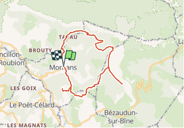
Trail Walking of 16.3 km to be discovered at Auvergne-Rhône-Alpes, Drôme, Mornans. This trail is proposed by genepy01.

Description

départ  parking avant la mairie de mornans

Elevation profile

Positioning

Country:
France
Region :
Auvergne-Rhône-Alpes
Department/Province :
Drôme
Municipality :
Mornans
Location:
Unknown
Start:(UTM)
668619 ; 4942894 (31T) N.

Trails nearby

Trail Walking Bourdeaux - Chemin des protestants- Bourdaux - Photo
Walking
crocau

Walking

Medium
(1)
Bourdeaux, Auvergne-Rhône-Alpes, Drôme, France
7.9 km | 11.2 km-effort
2h 48min
Yes
Trail Walking Francillon-sur-Roubion - Balade à francillon sur roubion - description et photos - Photo
Walking
bob2023

Walking

Easy
(1)
Francillon-sur-Roubion, Auvergne-Rhône-Alpes, Drôme, France
5 km | 6.7 km-effort
1h 36min
Yes
Trail Walking Saou - roche Colombe - Photo
Walking
bob2023

Walking

Medium
(1)
Saou, Auvergne-Rhône-Alpes, Drôme, France
10.9 km | 16.8 km-effort
3h 58min
Yes
Trail Walking Saou - saou.les 3 becs - Photo
Walking
Lemichmich

Walking

Difficult
(3)
Saou, Auvergne-Rhône-Alpes, Drôme, France
22 km | 40 km-effort
6h 46min
Yes
Trail Walking Saou - Les 3 Becs, le Veyou, le Signal et Rochecourbe - Photo
Walking
tracegps

Walking

Difficult
(3)
Saou, Auvergne-Rhône-Alpes, Drôme, France
18.5 km | 36 km-effort
8h 0min
Yes
Trail Walking Saou - Entre Roc et Estang - Photo
Walking
tracegps

Walking

Medium
(1)
Saou, Auvergne-Rhône-Alpes, Drôme, France
5.2 km | 7.5 km-effort
1h 15min
Yes
Trail Road bike Mornans - Col de Chaudiere, Saillans, Col de muse, Crupies - Photo
Road bike
GUIDE
nadd73

Road bike

Difficult
Mornans, Auvergne-Rhône-Alpes, Drôme, France
80 km | 105 km-effort
4h 27min
Yes
Trail Walking Saou - Saou : petite balade en forêt  - Photo
Walking
Jgar

Walking

Medium
Saou, Auvergne-Rhône-Alpes, Drôme, France
7.4 km | 10.9 km-effort
2h 28min
Yes
Trail Walking Bézaudun-sur-Bîne - Fonderesse - Photo
Walking
AIGUIER

Walking

Difficult
Bézaudun-sur-Bîne, Auvergne-Rhône-Alpes, Drôme, France
13.8 km | 22 km-effort
27h 34min
Yes


Close
My subscriptions