![](/images/other/stat-length.png)
![Trail Walking Omblèze - Le tour du Roc de Toulau - Photo](https://media.geolcdn.com/t/1900/400/7dec5712-619b-4e8e-b425-28d704421370.jpg&format=pjpeg&maxdim=2)
Le tour du Roc de Toulau
Philindy26
User
![Length](/images/other/stat-length.png)
![Max alt](https://static1.geolcdn.com/siteimages/upload/files/1508320355ic_sort_altitude_max_24dp.png)
![Uphill gradient](https://static1.geolcdn.com/siteimages/upload/files/1508320355ic_sort_den_pos_24dp.png)
![Km-Effort](/images/other/stat-length.png)
![Min alt](https://static1.geolcdn.com/siteimages/upload/files/1508320355ic_sort_altitude_min_24dp.png)
![Downhill gradient](https://static1.geolcdn.com/siteimages/upload/files/1508320355ic_sort_den_neg_24dp.png)
![Boucle](https://static1.geolcdn.com/siteimages/upload/files/16400158638029165_repeat_loop_refresh_sync_direction_icon.png)
![Walking](https://static1.geolcdn.com/sitytour/trail-icons/101.png)
3h20
Difficulty : Medium
![Scan this QR Code to open this trail in the SityTrail application](https://capi.geolives.com/qq0zvz2zws4bq2lad0pu/sitytour/trails/2963555/qr.png?size=200)
FREE GPS app for hiking
About
Trail Walking of 9.1 km to be discovered at Auvergne-Rhône-Alpes, Drôme, Omblèze. This trail is proposed by Philindy26.
Description
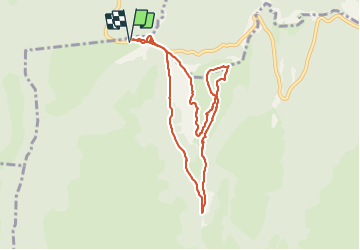
Départ du Col de la Bataille, parking en bordure de route avant le tunnel côté Léoncel...
Géolocalisation (Google Maps) : https://goo.gl/maps/i3CNFkUbuV1uNkep7
Rejoindre le Col en traversant le tunnel par le GR 93...
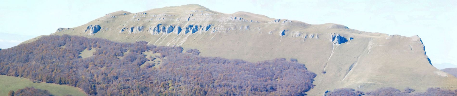
Au col de la Bataille (1313 m), prendre le sentier à droite du panneau du col et qui monte directement tout schuss sur le Roc de Toulau...
Ce sentier est très aérien et demande d'avoir un pied sûr. Cette montée a un dénivelé d'environ 200 mètres.
Arrivé sur la plateau, prendre à droite pour suivre le bord des falaises Ouest et rejoindre le point culminant du Roc de Toulau à 1581 m.
Continuer jusqu'à la pointe Sud (1547 m) et revenir par les falaises Est afin d'arriver jusqu'à la pointe Nord (1516 m).
Là, suivre les falaises Nord sur environ 250 mètres, puis traverser le plateau en direction du Sud-Est afin de retrouver le sentier en balcon qui vous emmènera au col de Toulau.
Continuer pour arriver au Pas du Gouillat (1328 m) et là prendre la piste au Nord (GR 93) pour revenir au Col de la Bataille.
Positioning
Comments
Trails nearby
![Trail Walking Omblèze - 2021-07-26_17h20m33_1627312809705_Plateau d_Ambel 15km.gpx.xml - Photo](https://media.geolcdn.com/t/375/260/07e91571-7633-48aa-a91e-19fa46a2d0cc.jpg&format=jpg&maxdim=2)
![Walking Walking](https://static1.geolcdn.com/sitytour/trail-icons/101.png)
Walking
![](/images/other/stat-length.png)
![](https://static1.geolcdn.com/siteimages/upload/files/16400158638029165_repeat_loop_refresh_sync_direction_icon.png)
![Trail Walking Le Chaffal - 26 vacherie arches comberoufle - Photo](https://media.geolcdn.com/t/375/260/27ca79a9-2463-4a38-9d47-59fa4758352c.jpg&format=jpg&maxdim=2)
![Walking Walking](https://static1.geolcdn.com/sitytour/trail-icons/101.png)
Walking
![](/images/other/stat-length.png)
![](https://static1.geolcdn.com/siteimages/upload/files/16400158638029165_repeat_loop_refresh_sync_direction_icon.png)
![Trail Walking Bouvante - 26 bouvante pas ligue st truite - Photo](https://media.geolcdn.com/t/375/260/9494233e-7248-475d-add1-20018e6bbb97.jpg&format=jpg&maxdim=2)
![Walking Walking](https://static1.geolcdn.com/sitytour/trail-icons/101.png)
Walking
![](/images/other/stat-length.png)
![](https://static1.geolcdn.com/siteimages/upload/files/16400158638029165_repeat_loop_refresh_sync_direction_icon.png)
![Trail Walking Omblèze - 26 pas de la sausse - Photo](https://media.geolcdn.com/t/375/260/ext.jpg?maxdim=2&url=https%3A%2F%2Fservices.sitytrail.com%2FGeolivesWS%2FDownloadMedia.ashx%3FTrailID%3D472646%26Media%3Dfix__20140403141012.jpg)
![Walking Walking](https://static1.geolcdn.com/sitytour/trail-icons/101.png)
Walking
![](/images/other/stat-length.png)
![](https://static1.geolcdn.com/siteimages/upload/files/16400158638029165_repeat_loop_refresh_sync_direction_icon.png)
![Trail Walking Léoncel - Pierre Chauve depuis le Col de Tourniol - Photo](https://media.geolcdn.com/t/375/260/ext.jpg?maxdim=2&url=https%3A%2F%2Fstatic1.geolcdn.com%2Fsiteimages%2Fupload%2Ffiles%2F1553511878bg_sport_marche.png)
![Walking Walking](https://static1.geolcdn.com/sitytour/trail-icons/101.png)
Walking
![](/images/other/stat-length.png)
![](https://static1.geolcdn.com/siteimages/upload/files/16400158638029165_repeat_loop_refresh_sync_direction_icon.png)
![Trail Mountain bike Léoncel - Tête de la Dame - Photo](https://media.geolcdn.com/t/375/260/ext.jpg?maxdim=2&url=https%3A%2F%2Fstatic1.geolcdn.com%2Fsiteimages%2Fupload%2Ffiles%2F1524743154velo.jpg)
![Mountain bike Mountain bike](https://static1.geolcdn.com/sitytour/trail-icons/202.png)
Mountain bike
![](/images/other/stat-length.png)
![](https://static1.geolcdn.com/siteimages/upload/files/16400158638029165_repeat_loop_refresh_sync_direction_icon.png)
![Trail Walking Le Chaffal - Col de la Bataille, Omblèze - Photo](https://media.geolcdn.com/t/375/260/23572a18-c053-46ab-b650-7388c57687af.jpg&format=jpg&maxdim=2)
![Walking Walking](https://static1.geolcdn.com/sitytour/trail-icons/101.png)
Walking
![](/images/other/stat-length.png)
![](https://static1.geolcdn.com/siteimages/upload/files/16400158638029165_repeat_loop_refresh_sync_direction_icon.png)
![Trail Walking Le Chaffal - les arches de Combleroufle - Photo](https://media.geolcdn.com/t/375/260/d3d11a7f-607e-4366-bcda-e95ee5b96279.jpg&format=jpg&maxdim=2)
![Walking Walking](https://static1.geolcdn.com/sitytour/trail-icons/101.png)
Walking
![](/images/other/stat-length.png)
![](https://static1.geolcdn.com/siteimages/upload/files/16400158638029165_repeat_loop_refresh_sync_direction_icon.png)
![Trail Walking Bouvante - Tour du Plateau d’Ambel - Photo](https://media.geolcdn.com/t/375/260/e9263bec-855c-46bf-86cc-d41c26b67066.jpg&format=jpg&maxdim=2)
![Walking Walking](https://static1.geolcdn.com/sitytour/trail-icons/101.png)
Walking
![](/images/other/stat-length.png)
![](https://static1.geolcdn.com/siteimages/upload/files/16400158638029165_repeat_loop_refresh_sync_direction_icon.png)