![](/images/other/stat-length.png)
![Trail Walking Cavalaire-sur-Mer - Fenouillet Les Pradels - Photo](https://media.geolcdn.com/t/1900/400/ext.pjpeg?maxdim=2&url=https%3A%2F%2Fstatic1.geolcdn.com%2Fsiteimages%2Fupload%2Ffiles%2F1553511878bg_sport_marche.png)
Fenouillet Les Pradels
PhL83
User
![Length](/images/other/stat-length.png)
Length
13.1 km
![Max alt](https://static1.geolcdn.com/siteimages/upload/files/1508320355ic_sort_altitude_max_24dp.png)
Max alt
350 m
![Uphill gradient](https://static1.geolcdn.com/siteimages/upload/files/1508320355ic_sort_den_pos_24dp.png)
Uphill gradient
496 m
![Km-Effort](/images/other/stat-length.png)
Km-Effort
19.7 km
![Min alt](https://static1.geolcdn.com/siteimages/upload/files/1508320355ic_sort_altitude_min_24dp.png)
Min alt
13 m
![Downhill gradient](https://static1.geolcdn.com/siteimages/upload/files/1508320355ic_sort_den_neg_24dp.png)
Downhill gradient
480 m
![Boucle](https://static1.geolcdn.com/siteimages/upload/files/16400158638029165_repeat_loop_refresh_sync_direction_icon.png)
Boucle
No
Creation date :
2021-10-07 07:23:52.0
Updated on :
2021-10-08 15:46:30.721
![Walking](https://static1.geolcdn.com/sitytour/trail-icons/101.png)
5h38
Difficulty : Very difficult
![Scan this QR Code to open this trail in the SityTrail application](https://capi.geolives.com/qq0zvz2zws4bq2lad0pu/sitytour/trails/2961329/qr.png?size=200)
FREE GPS app for hiking
About
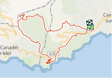
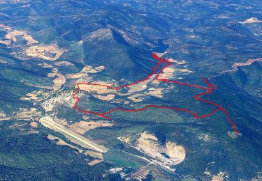
Trail Walking of 13.1 km to be discovered at Provence-Alpes-Côte d'Azur, Var, Cavalaire-sur-Mer. This trail is proposed by PhL83.
Description
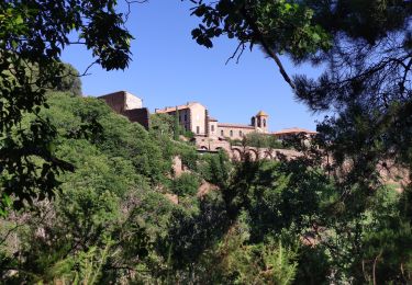
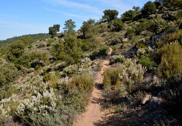
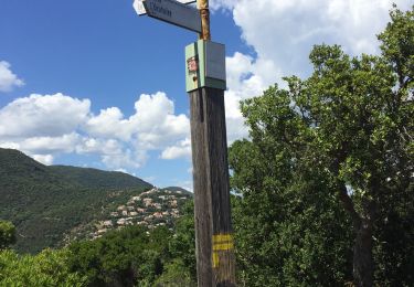
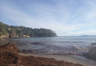
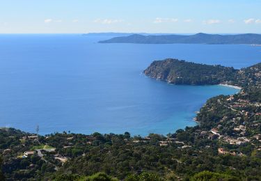
Belle randonnée en partant de Cavalaire près de la plage de Bonporteau. Elle permet ensuite de gagner les crêtes du Rayol Canadel et d'offrir de superbes panoramas sur la mer tant vers l'Est que l'Ouest et les Iles d'Or.
Positioning
Country:
France
Region :
Provence-Alpes-Côte d'Azur
Department/Province :
Var
Municipality :
Cavalaire-sur-Mer
Location:
Unknown
Start:(Dec)
Start:(UTM)
298121 ; 4782233 (32T) N.
Comments
Trails nearby
![Trail Walking La Môle - SityTrail - SityTrail - la mole - Photo](https://media.geolcdn.com/t/375/260/0ba0349d-6bb2-4249-b45a-746244491cb5.jpg&format=jpg&maxdim=2)
![Walking Walking](https://static1.geolcdn.com/sitytour/trail-icons/101.png)
SityTrail - SityTrail - la mole
Walking
Medium
(2)
La Môle,
Provence-Alpes-Côte d'Azur,
Var,
France
![](/images/other/stat-length.png)
15.3 km | 21 km-effort
6h 0min
![](https://static1.geolcdn.com/siteimages/upload/files/16400158638029165_repeat_loop_refresh_sync_direction_icon.png)
Yes
![Trail Mountain bike La Môle - VTT - La Mole - Barrage de La Verne - Chartreuse de La Verne - Capelude - Retour La Mole par les crêtes - Photo](https://media.geolcdn.com/t/375/260/977ec82e-6359-4a66-ab94-b782942b304d.jpg&format=jpg&maxdim=2)
![Mountain bike Mountain bike](https://static1.geolcdn.com/sitytour/trail-icons/202.png)
VTT - La Mole - Barrage de La Verne - Chartreuse de La Verne - Capelude - Ret...
Mountain bike
Difficult
La Môle,
Provence-Alpes-Côte d'Azur,
Var,
France
![](/images/other/stat-length.png)
34 km | 45 km-effort
4h 41min
![](https://static1.geolcdn.com/siteimages/upload/files/16400158638029165_repeat_loop_refresh_sync_direction_icon.png)
Yes
![Trail Walking Rayol-Canadel-sur-Mer - Wikiloc - Le rayon canadel - Opidum de monjean - Photo](https://media.geolcdn.com/t/375/260/4e43ac4c-7667-474b-8d0a-9263d51cfdde.jpg&format=jpg&maxdim=2)
![Walking Walking](https://static1.geolcdn.com/sitytour/trail-icons/101.png)
Wikiloc - Le rayon canadel - Opidum de monjean
Walking
Difficult
Rayol-Canadel-sur-Mer,
Provence-Alpes-Côte d'Azur,
Var,
France
![](/images/other/stat-length.png)
14.8 km | 24 km-effort
6h 0min
![](https://static1.geolcdn.com/siteimages/upload/files/16400158638029165_repeat_loop_refresh_sync_direction_icon.png)
Yes
![Trail Walking Rayol-Canadel-sur-Mer - 20190222 rayol canadel - Photo](https://media.geolcdn.com/t/375/260/ext.jpg?maxdim=2&url=https%3A%2F%2Fstatic1.geolcdn.com%2Fsiteimages%2Fupload%2Ffiles%2F1553511878bg_sport_marche.png)
![Walking Walking](https://static1.geolcdn.com/sitytour/trail-icons/101.png)
20190222 rayol canadel
Walking
Easy
(1)
Rayol-Canadel-sur-Mer,
Provence-Alpes-Côte d'Azur,
Var,
France
![](/images/other/stat-length.png)
8 km | 11.1 km-effort
2h 38min
![](https://static1.geolcdn.com/siteimages/upload/files/16400158638029165_repeat_loop_refresh_sync_direction_icon.png)
Yes
![Trail Walking Cavalaire-sur-Mer - Cavalaire 2 - Photo](https://media.geolcdn.com/t/375/260/66220656-f369-437d-a3c4-6a7ae56dd908.jpg&format=jpg&maxdim=2)
![Walking Walking](https://static1.geolcdn.com/sitytour/trail-icons/101.png)
Cavalaire 2
Walking
Difficult
Cavalaire-sur-Mer,
Provence-Alpes-Côte d'Azur,
Var,
France
![](/images/other/stat-length.png)
9.3 km | 13.6 km-effort
3h 5min
![](https://static1.geolcdn.com/siteimages/upload/files/16400158638029165_repeat_loop_refresh_sync_direction_icon.png)
Yes
![Trail Walking Cavalaire-sur-Mer - Langaste Peinier le Col des Tuiles et retour - Photo](https://media.geolcdn.com/t/375/260/ext.jpg?maxdim=2&url=https%3A%2F%2Fstatic1.geolcdn.com%2Fsiteimages%2Fupload%2Ffiles%2F1553511878bg_sport_marche.png)
![Walking Walking](https://static1.geolcdn.com/sitytour/trail-icons/101.png)
Langaste Peinier le Col des Tuiles et retour
Walking
Difficult
(1)
Cavalaire-sur-Mer,
Provence-Alpes-Côte d'Azur,
Var,
France
![](/images/other/stat-length.png)
9.7 km | 14 km-effort
3h 10min
![](https://static1.geolcdn.com/siteimages/upload/files/16400158638029165_repeat_loop_refresh_sync_direction_icon.png)
Yes
![Trail Hybrid bike Rayol-Canadel-sur-Mer - Vélo le col du Canadel et Parc de Port Cros - Photo](https://media.geolcdn.com/t/375/260/f6923b94-ab5d-42bf-aac8-dcd63edeb7c2.jpg&format=jpg&maxdim=2)
![Hybrid bike Hybrid bike](https://static1.geolcdn.com/sitytour/trail-icons/203.png)
Vélo le col du Canadel et Parc de Port Cros
Hybrid bike
Medium
Rayol-Canadel-sur-Mer,
Provence-Alpes-Côte d'Azur,
Var,
France
![](/images/other/stat-length.png)
43 km | 53 km-effort
3h 28min
![](https://static1.geolcdn.com/siteimages/upload/files/16400158638029165_repeat_loop_refresh_sync_direction_icon.png)
Yes
![Trail Walking Rayol-Canadel-sur-Mer - Rayol 21.1.23 - Photo](https://media.geolcdn.com/t/375/260/94d35f60-4441-4919-856b-aad9de111be5.jpg&format=jpg&maxdim=2)
![Walking Walking](https://static1.geolcdn.com/sitytour/trail-icons/101.png)
Rayol 21.1.23
Walking
Easy
Rayol-Canadel-sur-Mer,
Provence-Alpes-Côte d'Azur,
Var,
France
![](/images/other/stat-length.png)
8.5 km | 13.1 km-effort
2h 44min
![](https://static1.geolcdn.com/siteimages/upload/files/16400158638029165_repeat_loop_refresh_sync_direction_icon.png)
Yes
![Walking Walking](https://static1.geolcdn.com/sitytour/trail-icons/101.png)
Plage du Bonporteau et du Rayol
Walking
Medium
(1)
Cavalaire-sur-Mer,
Provence-Alpes-Côte d'Azur,
Var,
France
![](/images/other/stat-length.png)
16.6 km | 25 km-effort
4h 32min
![](https://static1.geolcdn.com/siteimages/upload/files/16400158638029165_repeat_loop_refresh_sync_direction_icon.png)
Yes