Trail Walking Le Rove - SityTrail - de l'Establon au port de la Vesse - Photo

SityTrail - de l'Establon au port de la Vesse

© OpenStreetMap contributors
Length
Length
7.6 km
Max alt
Max alt
138 m
Uphill gradient
Uphill gradient
294 m
Km-Effort
Km-Effort  
11.5 km
Min alt
Min alt
18 m
Downhill gradient
Downhill gradient
294 m
Boucle
Boucle
Yes
Creation date :
2021-10-07 08:06:48.146
Updated on :
2021-10-07 08:12:02.796

(0 Reviews)

Walking
Walking
2h36
Difficulty : Medium

Scan this QR Code to open this trail in the SityTrail application

FREE GPS app for hiking

Logo SityTrail SityTrail

IGN / Geographical institutes

Download SityTrail from the App Store Download SityTrail from Google Play

Logo SityTrail SityTrail World

The world is yours!

Download SityTrail from the App Store Download SityTrail from Google Play Download SityTrail on Huawei AppGallery

About

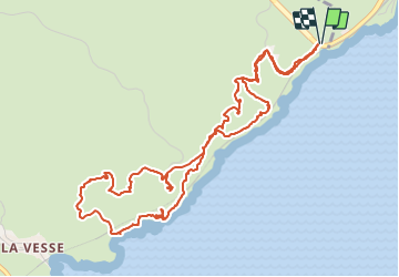
Trail Walking of 7.6 km to be discovered at Provence-Alpes-Côte d'Azur, Bouches-du-Rhône, Le Rove. This trail is proposed by Alain Derrives.

Description

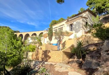
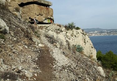
une petite randonnée en bord de mer
suivre le traçé jaune à l'aller et le bleu au retour

Elevation profile

Points of interest

Point of interest Le Rove - Vestiges de la guerre - Photo
Alain Derrives
Point of interest Le Rove - la grotte du Cap Rognon - Photo
Alain Derrives
Point of interest Le Rove - les port de la Vesse et de Niolon - Photo
Alain Derrives
Point of interest Le Rove - Le port de la Vesse - Photo
Alain Derrives
Point of interest Le Rove - vue du fort de Figuerolles - Photo
Alain Derrives

Positioning

Country:
France
Region :
Provence-Alpes-Côte d'Azur
Department/Province :
Bouches-du-Rhône
Municipality :
Le Rove
Location:
Unknown
Start:(UTM)
684920 ; 4802699 (31T) N.

Trails nearby

Trail Walking Le Rove - Calanque de la Vesse - Niolon la Vesse - Photo
Walking
tracegps

Walking

Medium
(1)
Le Rove, Provence-Alpes-Côte d'Azur, Bouches-du-Rhône, France
5.7 km | 8.3 km-effort
2h 15min
Yes
Trail Walking Le Rove - Côté bleue  - Photo
Walking
GUIDE
nadinebondoux

Walking

Difficult
Le Rove, Provence-Alpes-Côte d'Azur, Bouches-du-Rhône, France
13.2 km | 18.7 km-effort
4h 39min
Yes
Trail On foot Le Rove - Le fort de Niolon - Photo
On foot
GUIDE+

On foot

Easy
Le Rove, Provence-Alpes-Côte d'Azur, Bouches-du-Rhône, France
4.2 km | 6.6 km-effort
1h 29min
Yes
Trail Walking Le Rove - de Niolon à l'Erévine - Photo
Walking
GUIDE
amiral13

Walking

Easy
(1)
Le Rove, Provence-Alpes-Côte d'Azur, Bouches-du-Rhône, France
7.3 km | 11.1 km-effort
2h 47min
Yes
Trail Walking Le Rove - Cote bleue - Photo
Walking
GUIDE
nadinebondoux

Walking

Difficult
Le Rove, Provence-Alpes-Côte d'Azur, Bouches-du-Rhône, France
18.7 km | 26 km-effort
6h 48min
Yes
Trail Walking Le Rove - le Rove - Photo
Walking
GARROUSTE

Walking

Easy
(1)
Le Rove, Provence-Alpes-Côte d'Azur, Bouches-du-Rhône, France
8.7 km | 11.5 km-effort
2h 32min
Yes
Trail Walking Marseille - Sausset les Pins - Marseille - Photo
Walking
Baltykatt

Walking

Difficult
(1)
Marseille, Provence-Alpes-Côte d'Azur, Bouches-du-Rhône, France
25 km | 33 km-effort
7h 7min
No
Trail Walking Le Rove - de l'Establon au port de la Vesse - Photo
Walking
GUIDE
amiral13

Walking

Easy
Le Rove, Provence-Alpes-Côte d'Azur, Bouches-du-Rhône, France
9 km | 13.5 km-effort
5h 9min
Yes
Trail Walking Le Rove - N’isolons crêtes  - Photo
Walking
GUIDE
Roger Philippe Wallez

Walking

Difficult
Le Rove, Provence-Alpes-Côte d'Azur, Bouches-du-Rhône, France
13.1 km | 18.3 km-effort
5h 29min
Yes


Close
My subscriptions