![](/images/other/stat-length.png)
![Trail Walking Cassis - Mt Gibaou ,grotte janots Cassis. - Photo](https://media.geolcdn.com/t/1900/400/42166fc5-eaba-4bb6-92fc-82b6511d68cc.jpg&format=pjpeg&maxdim=2)
Mt Gibaou ,grotte janots Cassis.
cousam
User
![Length](/images/other/stat-length.png)
![Max alt](https://static1.geolcdn.com/siteimages/upload/files/1508320355ic_sort_altitude_max_24dp.png)
![Uphill gradient](https://static1.geolcdn.com/siteimages/upload/files/1508320355ic_sort_den_pos_24dp.png)
![Km-Effort](/images/other/stat-length.png)
![Min alt](https://static1.geolcdn.com/siteimages/upload/files/1508320355ic_sort_altitude_min_24dp.png)
![Downhill gradient](https://static1.geolcdn.com/siteimages/upload/files/1508320355ic_sort_den_neg_24dp.png)
![Boucle](https://static1.geolcdn.com/siteimages/upload/files/16400158638029165_repeat_loop_refresh_sync_direction_icon.png)
![Walking](https://static1.geolcdn.com/sitytour/trail-icons/101.png)
5h46
Difficulty : Medium
![Scan this QR Code to open this trail in the SityTrail application](https://capi.geolives.com/qq0zvz2zws4bq2lad0pu/sitytour/trails/2957664/qr.png?size=200)
FREE GPS app for hiking
About
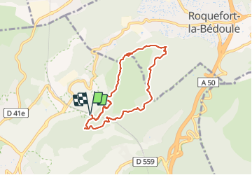
Trail Walking of 9 km to be discovered at Provence-Alpes-Côte d'Azur, Bouches-du-Rhône, Cassis. This trail is proposed by cousam.
Description
Boucle au départ du tunnel de Colongues
par le Mt Gibaou, le Baou de Redon, passer par la "grotte"( AR) ou une plaque en l'honneur de Frédèrique Mistral est fixé ,suivre le sentier sur les lapiaz, descendre un ressaut de 3m raide (prévoir corde) ,continué jusqu'à la grotte des Janots (frontale) et retour parking.
Positioning
Comments
Trails nearby
![Trail Road bike Cassis - 7909608-TRIMRS2017_Parcours Bike L V5 - Photo](https://media.geolcdn.com/t/375/260/3a21b855-f65e-4548-9ca8-5f083c8a8d79.jpg&format=jpg&maxdim=2)
![Road bike Road bike](https://static1.geolcdn.com/sitytour/trail-icons/201.png)
Road bike
![](/images/other/stat-length.png)
![](https://static1.geolcdn.com/siteimages/upload/files/16400158638029165_repeat_loop_refresh_sync_direction_icon.png)
![Walking Walking](https://static1.geolcdn.com/sitytour/trail-icons/101.png)
Walking
![](/images/other/stat-length.png)
![](https://static1.geolcdn.com/siteimages/upload/files/16400158638029165_repeat_loop_refresh_sync_direction_icon.png)
![Trail Walking Cassis - SityTrail - Les 3 Calanques - Cassis - Photo](https://media.geolcdn.com/t/375/260/6c8be29c-e655-4254-9b79-f66629a31e7b.jpg&format=jpg&maxdim=2)
![Walking Walking](https://static1.geolcdn.com/sitytour/trail-icons/101.png)
Walking
![](/images/other/stat-length.png)
![](https://static1.geolcdn.com/siteimages/upload/files/16400158638029165_repeat_loop_refresh_sync_direction_icon.png)
![Trail Walking Cassis - SityTrail - cassis la couronne - Photo](https://media.geolcdn.com/t/375/260/3dbefdc1-c4a5-41cb-82fb-882826196b25.jpg&format=jpg&maxdim=2)
![Walking Walking](https://static1.geolcdn.com/sitytour/trail-icons/101.png)
Walking
![](/images/other/stat-length.png)
![](https://static1.geolcdn.com/siteimages/upload/files/16400158638029165_repeat_loop_refresh_sync_direction_icon.png)
![Trail Walking La Ciotat - la ciotat - Photo](https://media.geolcdn.com/t/375/260/254a0458-8edc-4154-b242-76a735e7c994.jpg&format=jpg&maxdim=2)
![Walking Walking](https://static1.geolcdn.com/sitytour/trail-icons/101.png)
Walking
![](/images/other/stat-length.png)
![](https://static1.geolcdn.com/siteimages/upload/files/16400158638029165_repeat_loop_refresh_sync_direction_icon.png)
![Trail Walking Cassis - les calanques de Cassis - Photo](https://media.geolcdn.com/t/375/260/ext.jpg?maxdim=2&url=https%3A%2F%2Fservices.sitytrail.com%2FGeolivesWS%2FDownloadMedia.ashx%3FTrailID%3D572132%26Media%3Dfix__20160520153044.jpg)
![Walking Walking](https://static1.geolcdn.com/sitytour/trail-icons/101.png)
Walking
![](/images/other/stat-length.png)
![](https://static1.geolcdn.com/siteimages/upload/files/16400158638029165_repeat_loop_refresh_sync_direction_icon.png)
![Trail Walking Cassis - Traversée des Calanques 1/2 - Photo](https://media.geolcdn.com/t/375/260/ext.jpg?maxdim=2&url=https%3A%2F%2Fstatic1.geolcdn.com%2Fsiteimages%2Fupload%2Ffiles%2F1553511878bg_sport_marche.png)
![Walking Walking](https://static1.geolcdn.com/sitytour/trail-icons/101.png)
Walking
![](/images/other/stat-length.png)
![](https://static1.geolcdn.com/siteimages/upload/files/16400158638029165_repeat_loop_refresh_sync_direction_icon.png)
![Trail Walking Marseille - Calanques - Aiguille Eissadon - Col Devenson - En vau - Col l'Oule - Photo](https://media.geolcdn.com/t/375/260/ext.jpg?maxdim=2&url=https%3A%2F%2Fstatic1.geolcdn.com%2Fsiteimages%2Fupload%2Ffiles%2F1553511878bg_sport_marche.png)
![Walking Walking](https://static1.geolcdn.com/sitytour/trail-icons/101.png)
Walking
![](/images/other/stat-length.png)
![](https://static1.geolcdn.com/siteimages/upload/files/16400158638029165_repeat_loop_refresh_sync_direction_icon.png)
![Trail Walking Cassis - La Pointe Sud d'en Vau, depuis Cassis - Photo](https://media.geolcdn.com/t/375/260/ext.jpg?maxdim=2&url=https%3A%2F%2Fservices.sitytrail.com%2FGeolivesWS%2FDownloadMedia.ashx%3FTrailID%3D191386%26Media%3D14955_1.jpg)
![Walking Walking](https://static1.geolcdn.com/sitytour/trail-icons/101.png)
Walking
![](/images/other/stat-length.png)
![](https://static1.geolcdn.com/siteimages/upload/files/16400158638029165_repeat_loop_refresh_sync_direction_icon.png)