


atterrissage mad

jmheydorff
User
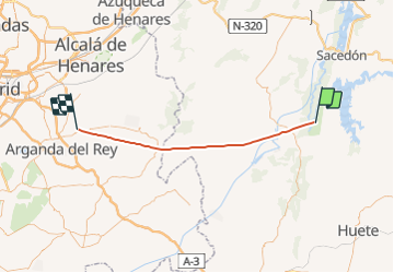

Length
52 km

Max alt
896 m

Uphill gradient
1395 m
Km-Effort
71 km

Min alt
591 m

Downhill gradient
1472 m
Boucle
No
Creation date :
2021-10-01 14:17:04.039
Updated on :
2021-10-01 14:38:00.906
6m
Difficulty : Very easy

FREE GPS app for hiking
 SityTrail
IGN / Geographical institutes
SityTrail World
The world is yours!
About
Trail Plane of 52 km to be discovered at Castile-La Mancha, Cuenca, Buendía. This trail is proposed by jmheydorff.
Positioning
Country:
Spain
Region :
Castile-La Mancha
Department/Province :
Cuenca
Municipality :
Buendía
Location:
Unknown
Start:(Dec)
Start:(UTM)
516919 ; 4466697 (30T) N.
Comments
Trails nearby