![](/images/other/stat-length.png)
combe de Veyranche
ajd26
User
![Length](/images/other/stat-length.png)
Length
21 km
![Max alt](https://static1.geolcdn.com/siteimages/upload/files/1508320355ic_sort_altitude_max_24dp.png)
Max alt
1973 m
![Uphill gradient](https://static1.geolcdn.com/siteimages/upload/files/1508320355ic_sort_den_pos_24dp.png)
Uphill gradient
1628 m
![Km-Effort](/images/other/stat-length.png)
Km-Effort
43 km
![Min alt](https://static1.geolcdn.com/siteimages/upload/files/1508320355ic_sort_altitude_min_24dp.png)
Min alt
755 m
![Downhill gradient](https://static1.geolcdn.com/siteimages/upload/files/1508320355ic_sort_den_neg_24dp.png)
Downhill gradient
1630 m
![Boucle](https://static1.geolcdn.com/siteimages/upload/files/16400158638029165_repeat_loop_refresh_sync_direction_icon.png)
Boucle
Yes
Creation date :
2021-09-30 06:53:26.0
Updated on :
2021-10-02 16:40:08.334
![Walking](https://static1.geolcdn.com/sitytour/trail-icons/101.png)
9h06
Difficulty : Very difficult
![Scan this QR Code to open this trail in the SityTrail application](https://capi.geolives.com/qq0zvz2zws4bq2lad0pu/sitytour/trails/2954981/qr.png?size=200)
FREE GPS app for hiking
About
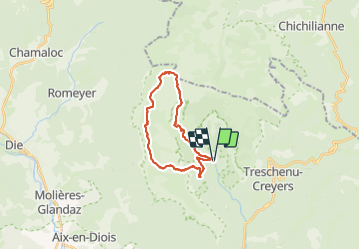
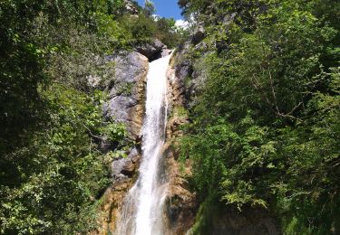
Trail Walking of 21 km to be discovered at Auvergne-Rhône-Alpes, Drôme, Châtillon-en-Diois. This trail is proposed by ajd26.
Description
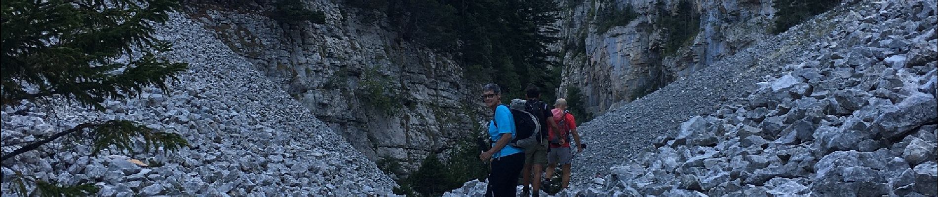
depart d'Archiane, montée très raide par la combe de Veyranche
et retour par la combe de l'Aubaise
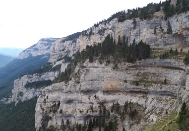
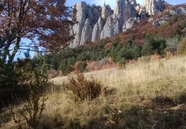
magnifiques panoramas
attention le pierrier de la combe de Veyranche est long et difficile mais pas dangereux
il faut avoir un peu d'entrainement mais c'est superbe
Positioning
Country:
France
Region :
Auvergne-Rhône-Alpes
Department/Province :
Drôme
Municipality :
Châtillon-en-Diois
Location:
Treschenu-Creyers
Start:(Dec)
Start:(UTM)
698456 ; 4957730 (31T) N.
Comments
Trails nearby
![Trail Walking Châtillon-en-Diois - 2015-05-30 11:51 - Photo](https://media.geolcdn.com/t/375/260/ext.jpg?maxdim=2&url=https%3A%2F%2Fmedia.geolcdn.com%2Ff%2Ff6b04bda-399a-4e8f-a718-7c3ac5f32c3c.jpg)
![Walking Walking](https://static1.geolcdn.com/sitytour/trail-icons/101.png)
2015-05-30 11:51
Walking
Very difficult
(1)
Châtillon-en-Diois,
Auvergne-Rhône-Alpes,
Drôme,
France
![](/images/other/stat-length.png)
13 km | 28 km-effort
6h 20min
![](https://static1.geolcdn.com/siteimages/upload/files/16400158638029165_repeat_loop_refresh_sync_direction_icon.png)
Yes
![Trail Walking Châtillon-en-Diois - F26 Combau Fontaine Pourrie - Photo](https://media.geolcdn.com/t/375/260/ext.jpg?maxdim=2&url=https%3A%2F%2Fservices.sitytrail.com%2FGeolivesWS%2FDownloadMedia.ashx%3FTrailID%3D311756%26Media%3Dfix__20140611142210.jpg)
![Walking Walking](https://static1.geolcdn.com/sitytour/trail-icons/101.png)
F26 Combau Fontaine Pourrie
Walking
Medium
(1)
Châtillon-en-Diois,
Auvergne-Rhône-Alpes,
Drôme,
France
![](/images/other/stat-length.png)
17 km | 29 km-effort
6h 9min
![](https://static1.geolcdn.com/siteimages/upload/files/16400158638029165_repeat_loop_refresh_sync_direction_icon.png)
Yes
![Trail Walking Châtillon-en-Diois - 2017-06-04 15:45:22 - Photo](https://media.geolcdn.com/t/375/260/ext.jpg?maxdim=2&url=https%3A%2F%2Fmedia.geolcdn.com%2Ff%2F4049bbeb-10e6-465f-8c97-cefb4daee153.jpg)
![Walking Walking](https://static1.geolcdn.com/sitytour/trail-icons/101.png)
2017-06-04 15:45:22
Walking
Medium
(1)
Châtillon-en-Diois,
Auvergne-Rhône-Alpes,
Drôme,
France
![](/images/other/stat-length.png)
11.4 km | 19.9 km-effort
Unknown
![](https://static1.geolcdn.com/siteimages/upload/files/16400158638029165_repeat_loop_refresh_sync_direction_icon.png)
Yes
![Trail Walking Châtillon-en-Diois - Vercors - Archiane - Cirque par les crêtes 21km D+1260m - Photo](https://media.geolcdn.com/t/375/260/ext.jpg?maxdim=2&url=https%3A%2F%2Fstatic1.geolcdn.com%2Fsiteimages%2Fupload%2Ffiles%2F1553511878bg_sport_marche.png)
![Walking Walking](https://static1.geolcdn.com/sitytour/trail-icons/101.png)
Vercors - Archiane - Cirque par les crêtes 21km D+1260m
Walking
Very difficult
(2)
Châtillon-en-Diois,
Auvergne-Rhône-Alpes,
Drôme,
France
![](/images/other/stat-length.png)
21 km | 38 km-effort
7h 55min
![](https://static1.geolcdn.com/siteimages/upload/files/16400158638029165_repeat_loop_refresh_sync_direction_icon.png)
Yes
![Trail Walking Châtillon-en-Diois - Carnets d'Archiane - Photo](https://media.geolcdn.com/t/375/260/ext.jpg?maxdim=2&url=https%3A%2F%2Fstatic1.geolcdn.com%2Fsiteimages%2Fupload%2Ffiles%2F1553511878bg_sport_marche.png)
![Walking Walking](https://static1.geolcdn.com/sitytour/trail-icons/101.png)
Carnets d'Archiane
Walking
Easy
(1)
Châtillon-en-Diois,
Auvergne-Rhône-Alpes,
Drôme,
France
![](/images/other/stat-length.png)
4.9 km | 9.7 km-effort
2h 1min
![](https://static1.geolcdn.com/siteimages/upload/files/16400158638029165_repeat_loop_refresh_sync_direction_icon.png)
No
![Trail Walking Châtillon-en-Diois - 26 vallon combeau - Photo](https://media.geolcdn.com/t/375/260/ext.jpg?maxdim=2&url=https%3A%2F%2Fmedia.geolcdn.com%2Ff%2F5dff522d-7866-41ae-b85a-1900434d82e5.jpg)
![Walking Walking](https://static1.geolcdn.com/sitytour/trail-icons/101.png)
26 vallon combeau
Walking
Medium
Châtillon-en-Diois,
Auvergne-Rhône-Alpes,
Drôme,
France
![](/images/other/stat-length.png)
13.3 km | 24 km-effort
6h 48min
![](https://static1.geolcdn.com/siteimages/upload/files/16400158638029165_repeat_loop_refresh_sync_direction_icon.png)
Yes
![Trail Walking Châtillon-en-Diois - Cabane de Chatillon - Photo](https://media.geolcdn.com/t/375/260/ext.jpg?maxdim=2&url=https%3A%2F%2Fmedia.geolcdn.com%2Ff%2Fea94f18f-fca1-490f-aab1-2356b5263731.jpg)
![Walking Walking](https://static1.geolcdn.com/sitytour/trail-icons/101.png)
Cabane de Chatillon
Walking
Medium
Châtillon-en-Diois,
Auvergne-Rhône-Alpes,
Drôme,
France
![](/images/other/stat-length.png)
17.6 km | 37 km-effort
6h 4min
![](https://static1.geolcdn.com/siteimages/upload/files/16400158638029165_repeat_loop_refresh_sync_direction_icon.png)
No
![Trail Walking Châtillon-en-Diois - Les crêtes du cirque d'Archiane - Photo](https://media.geolcdn.com/t/375/260/ext.jpg?maxdim=2&url=https%3A%2F%2Fmedia.geolcdn.com%2Ff%2F09133ccd-d124-4373-a8e4-85c1f4032737.jpg)
![Walking Walking](https://static1.geolcdn.com/sitytour/trail-icons/101.png)
Les crêtes du cirque d'Archiane
Walking
Difficult
Châtillon-en-Diois,
Auvergne-Rhône-Alpes,
Drôme,
France
![](/images/other/stat-length.png)
23 km | 41 km-effort
6h 35min
![](https://static1.geolcdn.com/siteimages/upload/files/16400158638029165_repeat_loop_refresh_sync_direction_icon.png)
Yes
![Trail Walking Châtillon-en-Diois - La Montagnette par le Pas de la Plane (Combau) - Photo](https://media.geolcdn.com/t/375/260/ext.jpg?maxdim=2&url=https%3A%2F%2Fmedia.geolcdn.com%2Ff%2F069e8df1-8a39-4ff7-975e-9e721d4c979e.JPG)
![Walking Walking](https://static1.geolcdn.com/sitytour/trail-icons/101.png)
La Montagnette par le Pas de la Plane (Combau)
Walking
Difficult
Châtillon-en-Diois,
Auvergne-Rhône-Alpes,
Drôme,
France
![](/images/other/stat-length.png)
11.4 km | 20 km-effort
4h 30min
![](https://static1.geolcdn.com/siteimages/upload/files/16400158638029165_repeat_loop_refresh_sync_direction_icon.png)
Yes