![](/images/other/stat-length.png)
![Trail Walking Salvizinet - Salvizinet, les ponts - Photo](https://media.geolcdn.com/t/1900/400/c69d1521-2db8-470f-b0c0-5530cf9080dd.jpg&format=pjpeg&maxdim=2)
Salvizinet, les ponts
mimi69670
User
![Length](/images/other/stat-length.png)
![Max alt](https://static1.geolcdn.com/siteimages/upload/files/1508320355ic_sort_altitude_max_24dp.png)
![Uphill gradient](https://static1.geolcdn.com/siteimages/upload/files/1508320355ic_sort_den_pos_24dp.png)
![Km-Effort](/images/other/stat-length.png)
![Min alt](https://static1.geolcdn.com/siteimages/upload/files/1508320355ic_sort_altitude_min_24dp.png)
![Downhill gradient](https://static1.geolcdn.com/siteimages/upload/files/1508320355ic_sort_den_neg_24dp.png)
![Boucle](https://static1.geolcdn.com/siteimages/upload/files/16400158638029165_repeat_loop_refresh_sync_direction_icon.png)
![Walking](https://static1.geolcdn.com/sitytour/trail-icons/101.png)
3h02
Difficulty : Easy
![Scan this QR Code to open this trail in the SityTrail application](https://capi.geolives.com/qq0zvz2zws4bq2lad0pu/sitytour/trails/2948470/qr.png?size=200)
FREE GPS app for hiking
About
Trail Walking of 11.9 km to be discovered at Auvergne-Rhône-Alpes, Loire, Salvizinet. This trail is proposed by mimi69670.
Description
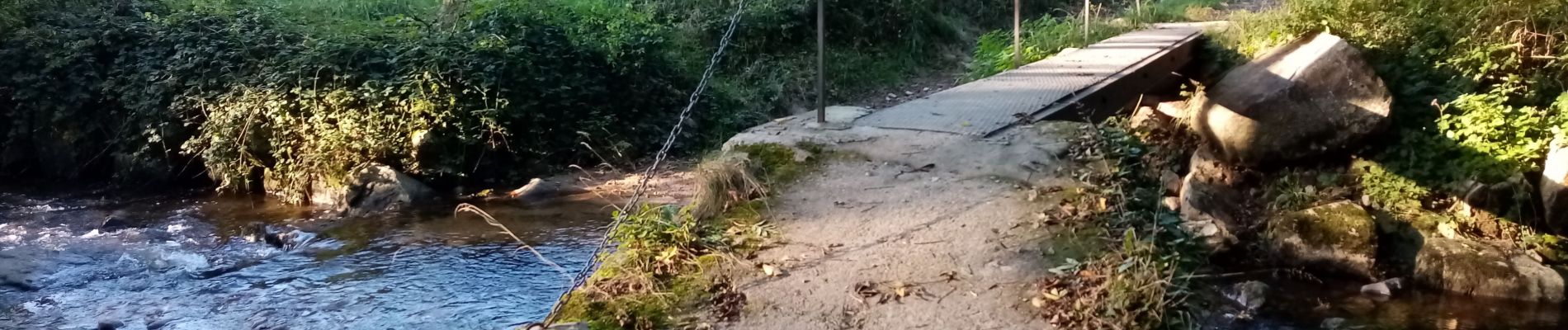
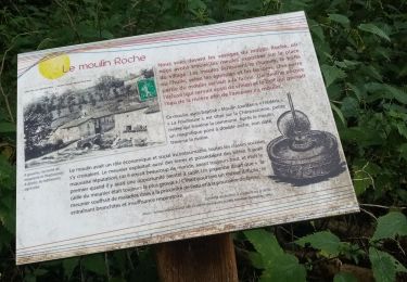
Départ de la mairie de Salvizinet, Rejoindre la rivière La Charpassonne.
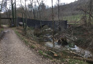
Passer sous l'ancien pont du monorail. Aller jusqu'à la Valette.
Continuer par des sentiers et croiser les ponts. Retour par la D113 jusqu'à Salvizinet.
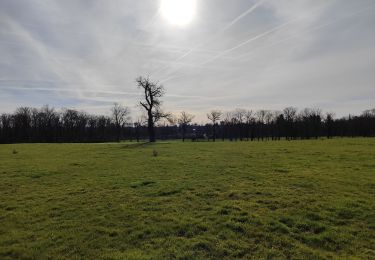
Salvizinet est un village pittoresque parsemé de rochers. Il est sur les hauteurs et offre une vue sur la plaine et les monts du Forez. Village classé 1 fleuri des villages de France.
Positioning
Comments
Trails nearby
![Trail Walking Salt-en-Donzy - Salt en Donzy - Photo](https://media.geolcdn.com/t/375/260/92e0799b-7397-4a83-951d-7d8dab5181d4.jpg&format=jpg&maxdim=2)
![Walking Walking](https://static1.geolcdn.com/sitytour/trail-icons/101.png)
Walking
![](/images/other/stat-length.png)
![](https://static1.geolcdn.com/siteimages/upload/files/16400158638029165_repeat_loop_refresh_sync_direction_icon.png)
![Trail Walking Feurs - Randonnée au dessus de Feurs - Photo](https://media.geolcdn.com/t/375/260/d2c52346-f2e5-4497-8257-48fbc24ee939.jpg&format=jpg&maxdim=2)
![Walking Walking](https://static1.geolcdn.com/sitytour/trail-icons/101.png)
Walking
![](/images/other/stat-length.png)
![](https://static1.geolcdn.com/siteimages/upload/files/16400158638029165_repeat_loop_refresh_sync_direction_icon.png)
![Trail Walking Pouilly-lès-Feurs - Randonnée de Pouilly les Feurs - Photo](https://media.geolcdn.com/t/375/260/0f77cdd6-65d8-41be-b44b-39fa6456f5ec.jpg&format=jpg&maxdim=2)
![Walking Walking](https://static1.geolcdn.com/sitytour/trail-icons/101.png)
Walking
![](/images/other/stat-length.png)
![](https://static1.geolcdn.com/siteimages/upload/files/16400158638029165_repeat_loop_refresh_sync_direction_icon.png)
![Trail Walking Essertines-en-Donzy - rando à partir de l'étang de la tuilerie - Photo](https://media.geolcdn.com/t/375/260/03d3503b-ae63-4901-b6b1-fb14fd833326.jpg&format=jpg&maxdim=2)
![Walking Walking](https://static1.geolcdn.com/sitytour/trail-icons/101.png)
Walking
![](/images/other/stat-length.png)
![](https://static1.geolcdn.com/siteimages/upload/files/16400158638029165_repeat_loop_refresh_sync_direction_icon.png)
![Trail Walking Salt-en-Donzy - rando au départ de Salt en Douzy, les 3 Chapelles - Photo](https://media.geolcdn.com/t/375/260/1d587284-1cc2-4d83-a606-db22cec9330d.jpg&format=jpg&maxdim=2)
![Walking Walking](https://static1.geolcdn.com/sitytour/trail-icons/101.png)
Walking
![](/images/other/stat-length.png)
![](https://static1.geolcdn.com/siteimages/upload/files/16400158638029165_repeat_loop_refresh_sync_direction_icon.png)
![Trail Walking Salt-en-Donzy - Salt-en-Donzy, petite montagne - Photo](https://media.geolcdn.com/t/375/260/252d959a-2962-4e4a-bcee-20640b08fc82.jpg&format=jpg&maxdim=2)
![Walking Walking](https://static1.geolcdn.com/sitytour/trail-icons/101.png)
Walking
![](/images/other/stat-length.png)
![](https://static1.geolcdn.com/siteimages/upload/files/16400158638029165_repeat_loop_refresh_sync_direction_icon.png)
![Trail Walking Salt-en-Donzy - rando à Salt en Douzy, boucle autour du chemin de monorail - Photo](https://media.geolcdn.com/t/375/260/ee316358-f7a5-4d9c-844b-66185530b4f7.jpg&format=jpg&maxdim=2)
![Walking Walking](https://static1.geolcdn.com/sitytour/trail-icons/101.png)
Walking
![](/images/other/stat-length.png)
![](https://static1.geolcdn.com/siteimages/upload/files/16400158638029165_repeat_loop_refresh_sync_direction_icon.png)
![Trail Walking Salvizinet - Salvizinet et vers monorail - Photo](https://media.geolcdn.com/t/375/260/5a0a9506-2bc1-45db-9a49-992d649dcc32.jpg&format=jpg&maxdim=2)
![Walking Walking](https://static1.geolcdn.com/sitytour/trail-icons/101.png)
Walking
![](/images/other/stat-length.png)
![](https://static1.geolcdn.com/siteimages/upload/files/16400158638029165_repeat_loop_refresh_sync_direction_icon.png)
![Trail Walking Salt-en-Donzy - Salt En Donzy - Photo](https://media.geolcdn.com/t/375/260/ext.jpg?maxdim=2&url=https%3A%2F%2Fstatic1.geolcdn.com%2Fsiteimages%2Fupload%2Ffiles%2F1553511878bg_sport_marche.png)
![Walking Walking](https://static1.geolcdn.com/sitytour/trail-icons/101.png)
Walking
![](/images/other/stat-length.png)
![](https://static1.geolcdn.com/siteimages/upload/files/16400158638029165_repeat_loop_refresh_sync_direction_icon.png)