Trail On foot Le Vernet-Sainte-Marguerite - le vernet sainte marguerite  le puy d'Alou 11 km - Photo

le vernet sainte marguerite le puy d'Alou 11 km

 jeanic63
jeanic63

User

© OpenStreetMap contributors
Length
Length
10.7 km
Max alt
Max alt
1089 m
Uphill gradient
Uphill gradient
259 m
Km-Effort
Km-Effort  
14.2 km
Min alt
Min alt
895 m
Downhill gradient
Downhill gradient
258 m
Boucle
Boucle
Yes
Creation date :
2021-09-22 07:25:51.832
Updated on :
2021-09-22 07:32:26.639

(0 Reviews)

On foot
On foot
3h13
Difficulty : Easy

Scan this QR Code to open this trail in the SityTrail application

FREE GPS app for hiking

Logo SityTrail SityTrail

IGN / Geographical institutes

Download SityTrail from the App Store Download SityTrail from Google Play

Logo SityTrail SityTrail World

The world is yours!

Download SityTrail from the App Store Download SityTrail from Google Play Download SityTrail on Huawei AppGallery

About

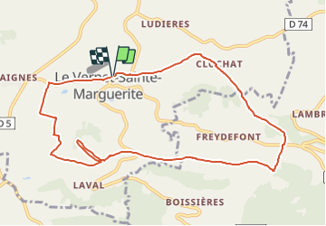
Trail On foot of 10.7 km to be discovered at Auvergne-Rhône-Alpes, Puy-de-Dôme, Le Vernet-Sainte-Marguerite. This trail is proposed by jeanic63.

Description

départ le Vernet sainte Marguerite a la sortie du village sur la d 145 avant le gite  d'étape

Elevation profile

Positioning

Country:
France
Region :
Auvergne-Rhône-Alpes
Department/Province :
Puy-de-Dôme
Municipality :
Le Vernet-Sainte-Marguerite
Location:
Unknown
Start:(UTM)
496048 ; 5050757 (31T) N.

Trails nearby

Trail Walking Chambon-sur-Lac - Chambon_Couze_Surains - Photo
Walking
GUIDE
jagarnier

Walking

Medium
(1)
Chambon-sur-Lac, Auvergne-Rhône-Alpes, Puy-de-Dôme, France
11.4 km | 16.6 km-effort
3h 30min
Yes
Trail Walking Le Vernet-Sainte-Marguerite - Vernet_Puy_Alou - Photo
Walking
GUIDE
jagarnier

Walking

Medium
(1)
Le Vernet-Sainte-Marguerite, Auvergne-Rhône-Alpes, Puy-de-Dôme, France
9.9 km | 13.1 km-effort
2h 50min
Yes
Trail Walking Saulzet-le-Froid - Le Puy Baladou - Photo
Walking
Gegetop

Walking

Easy
(4)
Saulzet-le-Froid, Auvergne-Rhône-Alpes, Puy-de-Dôme, France
12.5 km | 17.3 km-effort
2h 54min
Yes
Trail Walking Murol - Lac Chambon et château médiéval de Murol - Photo
Walking
tracegps

Walking

Medium
(4)
Murol, Auvergne-Rhône-Alpes, Puy-de-Dôme, France
8.9 km | 13.4 km-effort
2h 15min
Yes
Trail Walking Murol - Murol_Marais_Chambon - Photo
Walking
GUIDE
jagarnier

Walking

Medium
(1)
Murol, Auvergne-Rhône-Alpes, Puy-de-Dôme, France
7 km | 10.9 km-effort
2h 0min
Yes
Trail Walking Chambon-sur-Lac - Chambon_Moneaux - Photo
Walking
GUIDE
jagarnier

Walking

Medium
(1)
Chambon-sur-Lac, Auvergne-Rhône-Alpes, Puy-de-Dôme, France
15.5 km | 22 km-effort
4h 45min
Yes
Trail Walking Saint-Nectaire - Puy de Mazeires - Photo
Walking
tracegps

Walking

Medium
(2)
Saint-Nectaire, Auvergne-Rhône-Alpes, Puy-de-Dôme, France
8.2 km | 12 km-effort
3h 30min
Yes
Trail Equestrian Murol - 2022-08-07_19h25m34_J7 Murol - Montlosier 27km - Photo
Equestrian
jacky jouve

Equestrian

Medium
(1)
Murol, Auvergne-Rhône-Alpes, Puy-de-Dôme, France
27 km | 35 km-effort
Unknown
No
Trail On foot Chambon-sur-Lac - Voissière - Photo
On foot
GUIDE+

On foot

Easy
Chambon-sur-Lac, Auvergne-Rhône-Alpes, Puy-de-Dôme, France
9.4 km | 15 km-effort
3h 24min
Yes


Close
My subscriptions